During the morning hours of Tuesday, July 20th, a supercell thunderstorm tracked from the Brainerd area southeastward through the Twin Cities.
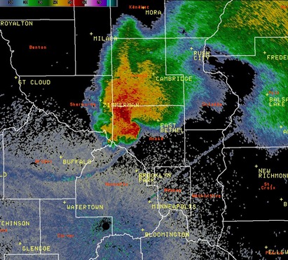
As the storm ascended on the Twin Cities metro, it began to show instances of hook echoes on radar. A hook echo is an indicator of tornado development. Here is a radar image that the National Weather Service in Chanhassen put together of a hook appendage in northwestern Anoka County at 10:45 AM. No tornado reports with this, but there was a public report of a funnel cloud about 15 minutes later at 11:02 AM in Maple Grove near the Interstate 494 and 694 junction.
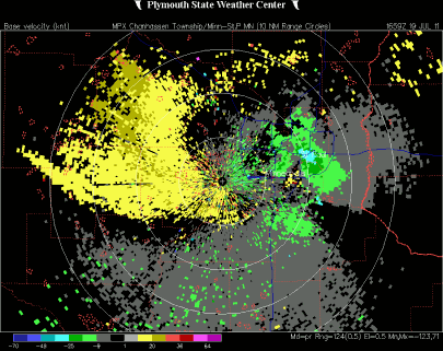
Radar was not picking up real strong rotation with this storm on the velocity scans that detect wind from different directions. This may have been one of the reasons why a tornado warning was not issued:
At first, I believed the funnel report was legitimate based on what I was seeing on radar at the time. However, as I was able to analyze the storm dynamics later, and seeing the storm first hand over my lunch break at work, I began to discredit the report. It appears the funnel was mistaken for the low, ragged clouds present with this storm. These are called scud clouds, which are nothing more than scary looking “junk” clouds that pose no immediate threat. This can often fool an untrained eye.
The sky also grew massively dark as the large cell completely covered the sunlight from the east, and it made people aware there was something brewing off in the distance. Here is video I found on YouTube of the storm as it rolled through:
The supercell with another apparent hook, as it appeared on radar, tracking through the Minneapolis and St. Paul downtowns and southward towards the Minneapolis-St. Paul International Airport at 11:59 AM:
Again, radar was not showing any areas of tight rotation with this storm on the velocity image that detects wind from different directions. The storm was a little better organized than earlier, but still no indicators of danger. It’s difficult for National Weather Service personnel to issue a tornado warning when there is no real evidence of a developing tornado. Although it’s best to err on the side of caution, you don’t want a “cry wolf” scenario to develop, and no one ends up heeding the warning. When NEXRAD was installed in the mid-90s to replace archaic World War II basic radar technology, velocity scans were one of the radar products introduced that provided clues to meteorologists as to the areas of greatest rotation that could eventually lead to tornado development.
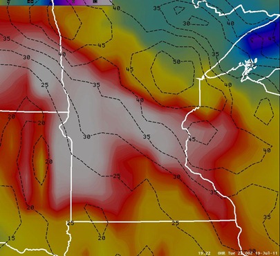
So we had the classic “hook” show up on radar, but why wasn’t there any rotation? Wind shear was not particularly strong this day as values were 40 knots across the thunderstorm area. For tornadoes to form, strong sheer must be present. In terms of speed, typically wind shear in excess of 40 knots is a good starting point. Although the image below is from later in the day at 5 PM, it is fairly representative of the wind shear present (noted in black) throughout the day on Tuesday. Shear was between 30 and 40 knots during the day across most of Minnesota.
The Storm Prediction Center noted in it’s 7:30 AM outlook the primary threats as large hail and damaging winds across Minnesota, but veering winds brought an isolated tornado threat to the area.
DEEP-LAYER VERTICAL SHEAR WILL NOT BE PARTICULARLY STRONG /I.E. LESS THAN 35 KT/...HOWEVER VERTICALLY VEERING WINDS INVOF SURFACE BOUNDARY WILL SUPPORT ORGANIZED STORM STRUCTURES CAPABLE OF LARGE HAIL...DAMAGING WINDS AND PERHAPS A TORNADO.
Due to the weaker wind shear, the storm reports received throughout the day where primarily from damaging winds across central Minnesota and western Wisconsin, but some hail reports were mixed in as well:
Hopefully this post helps explain why the storm was more impressive on radar, and that it had more “bark than bite”. Had better wind shear been present, a main ingredient for tornadoes, this could have been a very dangerous situation with perhaps a tornado near St. Paul and MSP airport. I don’t believe Minneapolis and St. Paul proper have been hit by different tornadoes in the same year. In my opinion, we dodged another close call for metropolitan storms in what would have been another bullet point in this whacky year of weather extremes that is 2011!
RS


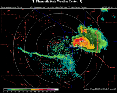


Nice post, Ryan! The deep layer shear was certainly the missing ingredient. There was a very pronounced roll cloud at the leading edge of the storm, which many people thought was tornadic. Just as we have always said in Skywarn training, if it looks like a steamroller (movement around a horizontal axis) - its not a wall cloud. LOTS of outflow. I had a vantage point from the 8th floor of an office building just south of KMSP, basically looking out on the airport, and what I think caused the "hook" echo was the rain and microburst coming down from the storm. The outflow was so strong that, like any microburst, the downdrafts were blown out from the storm and almost perpendicular from the storm motion. The 1659Z MPX base reflectivity screenshot above is great in showing this. The 88D is picking up the outflow/gustfront from Glencoe, bowing down through Carver and Scott Counties, and back up to near KMSP. The "hook" is right over the eastern border of Richfield, and the "notch" is over KMSP itself. I can tell you the rain and wind was definitely in microburst mode - as I witnessed it move across the airport and over us. There was outflow on the front and back sides of the rain shaft.
ReplyDeleteSo, that is my theory of the "hooking" echos we saw on the 88D. Clear in reflectivity at base/low angles of the beam was the effect of the outflow on the precip. Higher up in the storm the "couplet" typically found on base velocity and storm relative velocity views that verify the tornadic signature is non-existant. (I looked at some of the archive data on the Plymouth State site, but will spare the links here.) Proof that the hooking was sustained by surface based winds and NOT deep layer shear.
Pretty dramatic stuff, tho. Tops were over 50K on this baby, and the single cell storms earlier in the week were over 65K. That's TX-sized stuff! Rare for MN.
PS... SCUD = Scattered Cumulus Under Deck.
Cheers!
Thanks Kris for the very thorough reply, and filling in some of the holes!
ReplyDelete