Wednesday, October 24, 2012

Finally, some decent rains!

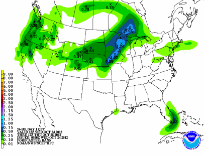
A sharp cold front will move across Minnesota tonight into Thursday morning, which should trigger some good rains across the eastern half of Minnesota.  As much of a half inch of rain is possible for the Twin Cities with up to an inch around Rochester from heavier storms.

fill_94qwbg

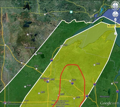
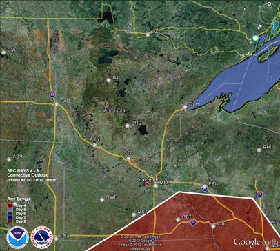
There is a slight risk of severe thunderstorms today along the cold front, but the concern is for far southeast Minnesota into west central Minnesota, noted in red below.  Twin Cities should remain severe-free.

svrthreat_102412

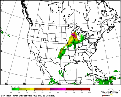
Tornadoes are possible this late in the year for Wisconsin, but an isolated risk for twisters exists from Rochester, and areas southeast.

CONUS_ETA212_ATMOS_STP-NEW_24HR

RS

Warmth streak is on the line

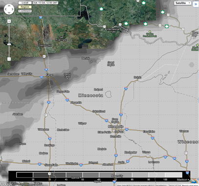
For the previous 16 months, the Twin Cities has experienced above normal temperatures.  The stretch of warm weather could come to an end in October as temperatures have remained below normal for a good portion of the month, but have climbed closer to normal over the last few days.  As of October 22nd, we are one degree below normal.  The forecast calls for a mild Wednesday before temperatures plummet and stay quite cool for the remainder of the week, with a chance of snow for far western Minnesota.

Month

Departure Above Normal (@MSP)

June 2011

1.1°

July 2011

5.6°

August 2011

2.4°

September 2011

0.9°

October 2011

6.4°

November 2011

5.5°

December 2011

8.1°

January 2012

7.7°

February 2012

6.9°

March 2012

15.5°

April 2012

2.5°

May 2012

4.6°

June 2012

3.5°

July 2012

6.4°

August 2012

0.8°

September 2012

1.9°

October 2012

???

Source: Minnesota Climatology Working Group

It’s going to be a close call!

RS

Tuesday, October 16, 2012

How much value does Winter forecasting provide?

During the 2011-12 snow season, the Twin Cities picked up 22.3 inches of snow, which was the ninth least snowiest season ever.

2011-12snowMSP

Many prognosticators were expecting much more snow during this La Niña period.  AccuWeather, a national private weather service, made perhaps the boldest and strongest statement when it issued it’s 2011-12 winter forecast in October 2011.

590x393_10041805_2011-12%20winter%20highlights%20us

The Midwest was expected to be hit hard by Old Man Winter that season, according to this weather service.  AccuWeather’s long-range meteorologist, Josh Nagelberg, declared, "People in Chicago are going to want to move after this winter."

590x393_10051514_wintercitiessnow

When it was all said and done, AccuWeather missed the forecast by nearly three feet of snow, and not too many Midwesterners were overly anxious to leave town.

AccuWeather Forecast Actual Error
MSP 56” 22.3” 33.7”

The long-time trusted publication since 1818, Farmers’ Almanac, released it’s seasonal winter forecast, indicating a very cold, but average snowfall.

2012-US-Farmers-Almanac-Winter-Map-Large-e1314389863213

It was anything but cold for the Twin Cities. We experienced the fourth warmest winter on record. The 30-year average (or normal) for snowfall in the Twin Cities is 54 inches.

msp_seasonal_snowfall

Farmers’ Almanac did not fare much better when it came to last season’s snowfall prediction with a similar forecast as AccuWeather.

Farmers’ Almanac Forecast Actual Error
MSP 54” 22.3” 31.7”

Locally, KSTP-TV meteorologist, Dave Dahl, proclaimed the Twin Cities would see a whopping 75 inches of snow for the season!

Screen shot 2011-10-28 at 9_31_51 PM

Unfortunately, Dahl was off by more than four feet of snow.

KSTP-TV Forecast Actual Error
MSP 75” 22.3” 52.7”

Local weather bloggers Paul Douglas and Paul Huttner had very similar predictions with near average snows. Douglas called for 50 to 55 inches of snow, while Huttner guessed 55.

Paul Douglas Forecast Actual Error
MSP 50-55” 22.3” 27.7-32.7”
Paul Huttner Forecast Actual Error
MSP 55” 22.3” 32.7”

A local statistician, Rigil Kent, for the The Minnesota Forecaster attempted a more data-driven, historical approach to snow forecasting.  He determined that 62.1 inches of snow would fall.  The winter didn’t play by the rule of probabilities.

Rigil Kent Forecast Actual Error
MSP 62.1” 22.3” 39.8”

The most accurate snow prediction I could find last season is attributed to the owner, and weather enthusiast of The Minnesota Forecaster, Bill Stein.  His prediction involved the amount of shedding by his dog, of all things.  His 43.1 inches call was closest to 22.3 inches of actual snow, but more than 20 inches off the mark.

Bill Stein Forecast Actual Error
MSP 43.1” 22.3” 20.8”

The private sector did not fare all that well with winter outlooks, so how did NOAA do?  Not much better.  Their revised 2011-12 forecast issued in December 2011 called for above normal precipitation for much of the northern tier of the continuous United States.
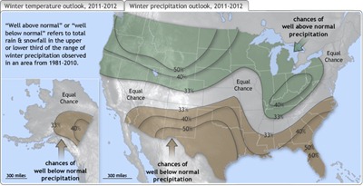
WinterPrecipOutlook2011_720

What does this all mean?  Winter forecasting should be taken with a grain of salt.  It is nothing more than just a guess.  Weather often doesn’t play by a regular set of rules, whether it’s an El Niño, La Niña, or neutral year.  Weather patterns can disrupt these seasonal influences.  In addition, predictions from local members of the media are not any better than national ones.

Willing to take a shot on how much snow will the Twin Cities see in 2012-13?  Post your guess below!

RS
Wednesday, October 10, 2012

Healthy dose of rain this weekend?

A strong low pressure area is forecast to track across Minnesota this weekend, bringing with it a very good chance of any decent precipitation in almost two months.

GFS_3_2012101000_F90_WSPD_10_M_ABOVE_GROUND

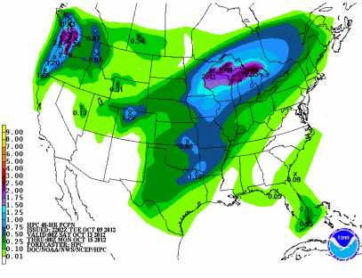
Many parts of the state could see upwards of an inch of much-needed rain or more from this powerful storm system.  This will no doubt decrease the degree of drought that plagues much of the state.

95e00p48iwbg_fill

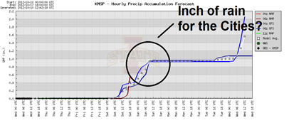
Taking a closer look at the Twin Cities, some of the models are spitting out about an inch of rain.

precip_10132012

Severe threat?

Over the last couple days, the Storm Prediction Center has highlighted southeastern Minnesota in their daily outlooks for the possibility of severe weather on Saturday.

svrthreatDay4_10132012

I’m not quite buying into this scenario, at least for Minnesota.  By Saturday morning, it appears we will dealing with cloud cover which will inhibit convective activity later in the day.  Both the European and American GFS model illustrate this.

Euro:

AMclouds_10102012

GFS:

bufkitoverview

Temperatures are going to struggle to get into the 60s I believe, which will diminish any substantial severe weather threat.  Dew points may get into the 60s, but the lack of any daytime heating will make moisture content irrelevant.  Instead, much of state will be dealing with quality, soaking rains.

RS

Wednesday, October 3, 2012

First seasonal snowfall across the state possible later this week

Our warm, and dry weather conditions with not much happening that has dominated the region over the last several months will come to an end soon as Thursday into Friday could bring the first snowfall of the 2012-13 season to Minnesota, specifically, the northwest portion of the state.  The models seem to be hinting at least at a few inches of the white stuff.

USA_ASNOWI1_sfc

snowNWMN

A powerful low pressure system, injected with Arctic air, sweeping across the international border is responsible for this early season snow.

A4P0wAaCUAEhony

While some may dread the thought of snow in early October, the area of the state being affected by this storm system is in great need of moisture.  Much of northwestern Minnesota is in “extreme” drought stage.

mn_dm_09252012

RS