Sunday, January 30, 2011

January going out like a lion

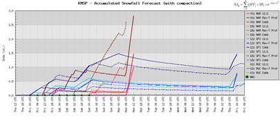
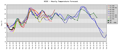
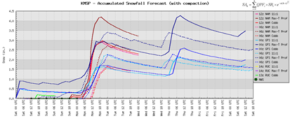
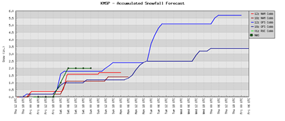
Snow will begin the work week with significant snow possible over southwest Minnesota, where locations there may pick up close to 10 inches of snow by Tuesday morning. Here in the Twin Cities metro, I believe 4 to 6 inches of snow is a real possibility over the same time period. Most definitely plowable. A light, continuous snow will begin late Sunday night around 10 PM and last until Tuesday morning, around 9 AM or so.

image

This storm crept up fast. Last Thursday, it wasn’t looking like much of anything, but by Friday night, all indications were higher snow totals were expected. At the time on Thursday, the forecast models were beginning to shift to higher amounts, but I wasn’t sure if it was an anomaly at the time since there was no trend to look at. This was a difficult storm to forecast. This will surely push out seasonal snowfall to about 60 inches in what is turning into quite a memorable winter.

Current warnings and advisories:

Winter Storm Warning valid at Jan 30, 6:00 PM CST for Blue Earth, Brown, Chippewa, Faribault, Freeborn, Kandiyohi, Lac qui Parle, Le Sueur, Martin, Nicollet, Redwood, Renville, Sibley, Steele, Swift, Waseca, Watonwan, Yellow Medicine [MN] till Feb 01, 6:00 AM CST.

Winter Weather Advisory valid at Jan 30, 6:00 PM CST for Anoka, Benton, Carver, Dakota, Douglas, Goodhue, Hennepin, Pope, Ramsey, Rice, Scott, Sherburne, Stearns, Stevens, Washington, Wright [MN] till Feb 01, 6:00 AM CST.

RS

Thursday, January 27, 2011

Shakopee spring flooding potential

Shakopee Valley Newspaper blog originally posted 1/27/11

The National Weather Service recently released it's outlook on the potential for spring flooding across the Upper Midwest.  As expected with the snow pack, flooding will be a concern.  For the Minnesota River at Shakopee, the numbers look like this:

There is a greater than 98 percent chance, an almost certainty, of waters reaching 711.4 feet, which would result in water reaching the lowest part of Highway 101.

An 89 percent chance exists for water to reach a flood stage of 714 feet, which would put such a crest in the top ten all-time.

Coming in next is an 81 percent chance of a crest reaching an additional foot at 715 feet. This would put it close to the 715.1 crest from March 2010.

Lastly, there is a 78 percent chance of waters reaching a stage of 716 feet, which would put it at number eight all-time.

To put in perspective, flood stage is 708 feet, moderate flooding is 713 feet, and major flood stage is 720 feet. As you can see, there is a strong chance Shakopee will see moderate flooding conditions, which will impact commuters using the 101 crossing, as it will likely be closed if the forecast holds true.  Stay tuned!

RS

Snow potential for the end of January

As we head towards the end of January, the weather pattern is geared towards a more quiet one and temperatures in the 30s come in for the weekend.

snow

Snow:  Through Monday, it appears that 1 to 1.5 inches of snow will fall by midnight Monday. Going out 7 days, we are looking at anywhere from 1 to 3 inches total across the metro – heavier amounts as you go northeast to southwest.

snow012711

EndJan11snow

Next week, we are looking at a big dip in the temperature, so get outside while you can this weekend, because it’s not going to last.  The heavy snow is taking a break and gives us all a chance to breathe.  I think it’s fair to say we all could use the break! Have a great weekend!

RS

Wednesday, January 26, 2011

Heat wave!

The bitter cold stretch that has plagued most of Minnesota for the last couple months is about to come to a brief end as warmer air is being driven up from the south.

The forecast map below, courtesy of Twister Data, shows temperatures approaching the freezing point Saturday around the noon hour.

heatwave

This is a welcome relief for many people that have felt down about this winter.  Personally, this has to be the worst winter in terms of brutality to the human spirit since the 1995-96 winter season, where we had a stretch of six consecutive nights of -20°F or colder.  As for myself, I’m going through a pretty bad case of seasonal affective disorder.  It’s been difficult to find the energy and motivation to live a normal lifestyle.  Winter activities just haven’t been real pleasant to participate in this year without feeling like you’re being pushed indoors.  This winter just sucks, I don’t know what else I can say about it.  Fortunately it appears the worst of the winter is over with and it’s just a matter of getting through March, the snowiest month of them all.  Usually, I can make it to March before I’m ready for spring, but this year my tolerance level has been cut much shorter.  When spring rolls around, I will not be taking it for granted!

RS

Sunday, January 23, 2011

NFC Championship Game weather conditions for Green Bay Packers at Chicago Bears

For the second time in post-season history, the Chicago Bears and Green Bay Packers will be matching up.  The Bears won the first meeting on December 14, 1941 in a divisional playoff.  This time, it’s the NFC Championship Game, and it will be to determine who goes on to Super Bowl XLV to take on the winner of the Pittsburgh Steelers and New York Jets in the AFC Championship Game.

Here are the weather conditions for the game that kicks off at 3:00 PM ET from Soldier Field in Chicago, IL:

chicagosnow

Precip:  Flurries are possible during the course of the game, which may leave a dusting on the field.

chicagotemp

Temperature:  Air temperature will range from 16 to 18 degrees during the game.  Winds will be from 5 to 10 miles per hour, creating a wind chill of around 5 degrees.

Enjoy the games today!

RS

Tuesday, January 18, 2011

Could it be...a February warmup?

Original blog entry from 1/18/2011 on the Shakopee News website:

I'm going to try to focus on something more positive with this blog entry. Since I started sharing weather wisdom here at the start of the year as a way to give back to the community, it's been all about snow and cold. This winter has been depressing, and talking with friends and reading some of the comments here, we share a similar feeling. When it gets so cold that it makes it difficult to enjoy winter hobbies, it wears on you. Combined with lack of sunlight, it's hard to maintain a regular energy level and keep up with life's demands.

Onto the good news - there are hints of a warmup on the horizon around the beginning of Febraury. We may even see a few days of temperatures above 20 degrees! A forecast this far out is always susceptible to change and will likely fluctuate a bit, but it's a trend most of us will appreciate as we head towards spring!

RS

Saturday, January 15, 2011

Looking ahead to Monday’s system

Friday’s snow brought 2 to 2.5 inches of snow across the Twin Cities metro area, with some reports of three inches or greater in west central Wisconsin.

More snow is on the way for Monday.  Early snow estimates from this storm indicate an average in the 1-3 inch range.  This appears to be a storm that will have a bit of variation in the totals, depending on where you live. The NAM is printing out heavier snow across the eastern metro and across the St. Croix into west central Wisconsin.

snow011711

image

Timing: The snow will start around midnight and will be coming down for the morning commute, so expect to be arriving to your destination a little bit later than normal. It will end late Monday night and I don’t expect the evening commute to be much better unfortunately.

Snow lovers have nothing to complain about this winter.  With March generally being the snowiest month, there’s a good chance we could be flirting with seasonal snow record.  With all the record-breaking events of 2010, nothing would surprise me anymore.

RS

Thursday, January 13, 2011

Same old, same old

Not much change to the weather story over the next week. More of the white powder and cold air moving into the area. Thursday’s snow amounts generally ranged between one and two inches.

The forecast into the weekend: Snow will be off and on Friday into the day on Saturday where the metro could pick up an additional two inches of snow. By Sunday, I’m expecting that we will have 50 inches of snow on the ground since October. That is more than halfway towards the record of 98.6 inches of snow that feel in 1983-84. The models are a little overdone for Monday, and I’m not expecting a significant storm early next week.

snow011311

The big chill is still expected to occur that I mentioned previously. However, the forecast models have pushed the extreme cold to Wednesday of next week. Lows as cold as –25 to -30°F are being advertised.

wedchill

For those of you fatigued by our winter, which I am certainly becoming, I will leave you this image. Enjoy!

green-grass-blue-sky

RS

Tuesday, January 11, 2011

Snow and more snow

Here are snow totals from across Minnesota from our latest storm system. This was more of a “nuisance” snow that lasted over two days and caused work commute headaches through Tuesday afternoon. The snow tapered off before the dinner hour. The west metro saw three to four inches of snow, while the east side had one to three. Nearly ten inches of snow fell in Southern Minnesota. The snowfall “winner” goes to Fairmont, with nine inches of snow at last report over the noon hour Tuesday.

snow011011_011101

INCHES LOCATION             ST  COUNTY      TIME
------ ------------------- -- --------- -------
9.00 FAIRMONT MN MARTIN 1200 PM
8.00 COMFREY MN BROWN 1200 PM
8.00 WELCOME MN MARTIN 1200 PM
8.00 AMBOY MN BLUE EARTH 1200 PM
8.00 MADELIA MN WATONWAN 0751 PM
7.00 NORTH MANKATO MN NICOLLET 1200 PM
KEYC TELEVISION STATION
7.00 BLUE EARTH MN FARIBAULT 1200 PM
7.00 MORGAN MN REDWOOD 1200 PM
6.70 NORTH MANKATO MN NICOLLET 1200 PM
COOPERATIVE OBSERVER
6.50 WINNEBAGO MN FARIBAULT 0656 AM
6.10 1 ENE MINNESOTA LAKE MN FARIBAULT 0805 AM
6.00 REDWOOD FALLS MN REDWOOD 1200 PM
6.00 SPRINGFIELD MN BROWN 1200 PM
6.00 1 NNW SPRINGFIELD MN BROWN 1200 PM
5.90 SSW MONTEVIDEO MN CHIPPEWA 1200 PM
5.50 SACRED HEART MN RENVILLE 0449 PM
5.50 ELLENDALE MN STEELE 0605 AM
5.50 BENSON MN SWIFT 0118 PM
5.50 ALBERT LEA MN FREEBORN 1200 PM
5.30 WINTHROP MN SIBLEY 0529 AM
5.10 3 SE NEW ULM MN BROWN 1200 PM
4.80 DONNELLY MN STEVENS 0915 AM
4.80 1 ESE MILROY MN REDWOOD 1200 PM
4.50 WASECA MN WASECA 1200 PM
4.50 1 SSW LONSDALE MN RICE 1200 PM
4.40 WILLMAR MN KANDIYOHI 1200 PM
4.40 HUTCHINSON MN MCLEOD 1200 PM
4.20 HAMBURG MN CARVER 1200 PM
4.20 SW ELLENDALE MN STEELE 1200 PM
4.00 MONTEVIDEO MN CHIPPEWA 1200 PM
4.00 BIRD ISLAND MN RENVILLE 1200 PM
4.00 1 SE HENDERSON MN LE SUEUR 1200 PM
3.50 MORRIS MN STEVENS 1200 PM
3.50 COLOGNE MN CARVER 449 PM
3.50 4 W OWATONNA MN STEELE 1200 PM
3.40 CHANHASSEN MN CARVER 1200 PM
3.30 W CARVER MN CARVER 1200 PM
3.20 WACONIA MN CARVER 1200 PM
3.20 GAYLORD MN SIBLEY 1200 PM
3.10 CHASKA MN CARVER 1200 PM
3.10 E OWATONNA MN STEELE 1200 PM
3.00 OWATONNA MN STEELE 1200 PM
2.90 WSW LONG LAKE MN HENNEPIN 1200 PM
2.90 3 ENE MONTGOMERY MN RICE 1200 PM
2.80 ST CLOUD MN STEARNS 1200 PM
CORRECTIONAL FACILITY
2.70 LAKEVILLE MN DAKOTA 1015 PM
2.60 MINNEAPOLIS MN HENNEPIN 1200 PM
MSP INTL AIRPORT
2.50 ST CLOUD MN STEARNS 1200 PM
SAINT CLOUD STATE UNIVERSITY
2.50 JORDAN MN SCOTT 1200 PM
2.50 LITTLE FALLS MN MORRISON 1200 PM
2.40 ROCKFORD MN HENNEPIN 1200 PM
2.40 INVER GROVE HEIGHTS MN DAKOTA 1200 PM
2.20 KIMBALL MN STEARNS 1200 PM
2.20 ARDEN HILLS MN RAMSEY 1200 PM
2.20 1 NNW COLD SPRING MN STEARNS 1200 PM
2.10 2 W PRIOR LAKE MN SCOTT 1200 PM
2.10 1 SW EDINA MN HENNEPIN 1200 PM
2.10 CHAMPLIN MN HENNEPIN 0434 PM
2.00 RED WING MN GOODHUE 0115 PM
2.00 RICE MN BENTON 1200 PM
2.00 WELLS MN FARIBAULT 1200 PM
2.00 BALDWIN WI ST. CROIX 1200 PM
2.00 3 SSW MINNEAPOLIS MN HENNEPIN 1200 PM
2.00 3 WSW PRINCETON MN SHERBURNE 1200 PM
2.00 DURAND WI PEPIN 1200 PM
2.00 3 NE BURNSVILLE MN DAKOTA 1200 PM
2.00 3 SE LAKE ELMO MN WASHINGTON 1200 PM
1.90 3 N ALEXANDRIA MN DOUGLAS 1200 PM
1.80 3 WNW ROSEMOUNT MN DAKOTA 1200 PM
1.70 ST PAUL MN RAMSEY 1200 PM
UNIVERSITY OF MINNESOTA
1.60 LONG PRAIRIE MN TODD 1200 PM
1.50 DASSEL MN MEEKER 1200 PM
1.50 ELK RIVER MN SHERBURNE 1200 PM
1.50 1 SW ROSEVILLE MN RAMSEY 1200 PM
1.50 2 SE CHETEK WI BARRON 1200 PM
1.50 1 SSW RIVER FALLS WI PIERCE 1200 PM
1.50 ELK MOUND WI DUNN 1200 PM
1.50 WSW LITTLE CANADA MN RAMSEY 1200 PM
1.40 AUGUSTA WI EAU CLAIRE 1200 PM
1.40 CHIPPEWA FALLS WI CHIPPEWA 1200 PM
1.40 SPRING VALLEY WI PIERCE 1200 PM
1.30 CANNON FALLS MN GOODHUE 1200 PM
1.30 FOREST LAKE MN WASHINGTON 1200 PM
1.20 2 NE RUSH CITY MN CHISAGO 1200 PM
1.10 ROBERTS WI ST. CROIX 1200 PM
1.00 ZUMBROTA MN GOODHUE 1200 PM
1.00 BLOOMER WI CHIPPEWA 1200 PM
1.00 MILACA MN MILLE LACS 1200 PM
1.00 MORA MN KANABEC 1200 PM
1.00 HOLCOMBE WI CHIPPEWA 1200 PM
1.00 CLEAR LAKE WI POLK 0417 PM
1.00 LADYSMITH WI RUSK 1200 PM
0.90 1 W WOODLAND MN HENNEPIN 1200 PM
0.80 2 WNW LADYSMITH WI RUSK 1200 PM
0.70 CUMBERLAND WI BARRON 1200 PM
0.60 ONAMIA MN MILLE LACS 1200 PM

More snow is on the way Friday, and it’s still too early to give a snow range as the models continue to fluctuate, but indications are that it will dump at least three inches over the metro - enough to shovel and plow.

RS

Sunday, January 9, 2011

Early week snow

A storm system moving in from the Rockies will drop some snow over Minnesota on Monday into Wednesday.  The snow amounts will be greater than any of the snow we have seen over the last week or so.  By Wednesday morning, we could be looking at 3 to 4 inches of snow.

snow011011

Heavier amounts of snow will be over the southwestern part of the state, 6 to 10 inches of snow possible, while east central and northern Minnesota will see lesser amounts (1-3 inches).

image

RS

Wednesday, January 5, 2011

Mid-January arctic chill

Long term forecasts are indicating a deep freezing over the northern tier of states starting around the 14th of the month and lasting to about the 19th.  This will be the coldest air we’ve had to deal with all winter season.  High temperatures will be well below zero with overnight temperatures near -20°F.  That’s not even factoring the wind, which is projected to be around 10 miles per hour for a dangerous wind chill near -40°F.

2011010518_CON_GFS_SFC_TEMP_IMAGE_264

If you haven’t already put the extra blankets on the bed from the closet, you may be digging them out fairly soon.  Brrrrr!

RS

Sunday, January 2, 2011

Top 5 Minnesota weather events of 2010

Welcome to 2011. 2010 is now in the books and was a crazy year for weather that Minnesotans experienced. From the snowless March, spring and fall flooding, record number of tornadoes, biggest outbreak of tornadoes in one day, record low pressure readings that brought destructive winds, the greatest winter storm to hit the Twin Cities and surrounding areas since the Halloween Blizzard of 1991, to the snowiest December on record. In reflection on 2010, here are my top 5 weather events for 2010. The top events as voted on by weather enthusiasts are here.

#5 Heavy rainfall on September 22-23, 2010

Waves of heavy rain moved across the southern portion of Minnesota over a two day period on September 22 and 23, triggering instant flash flooding. The highest total rainfall total received in the area was 11.06 inches from an observer in Faribault County, with many areas picking up 8+ inches. Paul Huttner said, “Some central Minnesota [towns] got a summer’s worth of rainfall in one day.” This rain ran off into the Minnesota River, which then flowed upstream into the Mississippi River. Many areas experienced near or record high water levels with this unusually fall flooding event.

ff100922-23

Here is video I captured of the Minnesota River flooding as it happened in Shakopee on October 2, 2010.

Locally, this was the seventh highest river crest in Shakopee, reaching 716.5 feet, causing the highway 101 river crossing in Shakopee and highway 41 in Chaska to be closed for a couple weeks until the river receded back into it’s banks.

#4 Record Low Pressure on October 26-27, 2010

On Monday, October 26th, an intense area of low pressure moved from the plains through Minnesota. The low developed in response to powerful jet stream winds from the west, and a major contrast in temperatures – warm, moist air to the south and cold air to the south . At 5:13 pm on Tuesday, October 27, 955.2 millibars (28.21 inches of mercury) was observed at Bigfork, Minnesota, located in the north central part of the state. Powerful winds occurred Tuesday as the low tracked in a south to north direction. Sustained winds of 30 to 45 mph with gusts of 50 to 65 mph were common. Tree branches were knocked down resulting in sporadic power outages. This put those without power in a dangerous situation as artic air moved in with no heat available. Fortunately, utility crews were able to restore power within a day.

sfclowanimation_gif
Graphic courtesy National Weather Service - Chanhassen

#3 The Great Blizzard of 2010 on December 10-11, 2010
10Dec11_18Zsfcmap

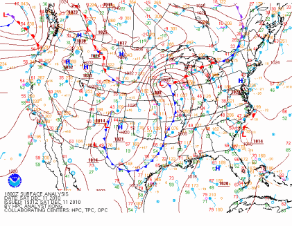
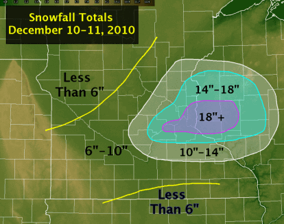
The largest snowfall in almost 20 years for the Twin Cities fell over the days of December 10 and 11. When the snow ended, it would be the largest snowstorm to affect the Twin Cities in December, and the fifth largest snowfall from any one storm on record. Strong winds associated with this storm created blizzard-like conditions across southern Minnesota and the southern parts of the Twin Cities metro, which reduced visibilities to one-quarter mile or less. This resulted in MSP airport being shut down for four hours. 17.1 inches of snow fell at the airport over the two days, and locally, I measured 21.5 inches of snow on the front sidewalk. To the east in Eau Claire, Wisconsin, the city picked up 22 inches of snow in one day, setting a new record.
Dec11_SnowMap4

The weight of all the snow collapsed the roof of the Metrodome in Minneapolis, MN. This was the fifth time the roof has been deflated since it was built in 1981, and fourth time due to heavy snow. Significant damage was done to the roof panels, and it is reported it will take until at least March to make the stadium operable again. Fox Network had cameras in place inside of the Dome and captured the remarkable roof collapse shown below.

#2 104 Tornadoes for 2010

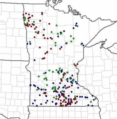
Minnesota saw the greatest number of tornadoes in one year during 2010 with 104 counted by the weather service offices - 71 of these occurring in the month of June. The red dots in the map below are locations where initial tornado reports were made during June. There are two distinct “tornado alleys”, the first over southern third of Minnesota and a second area over northwest Minnesota, north of the the Fargo, ND/Moorhead, MN area.
MN_statemapjune

The state shattered the previous annual record of 74, set in 2001. From 1950 to 2010, Minnesota averages 27 tornadoes a year, so the state saw 4 times as many tornadoes in a typical year.

#1 48 Tornadoes on June 17, 2010

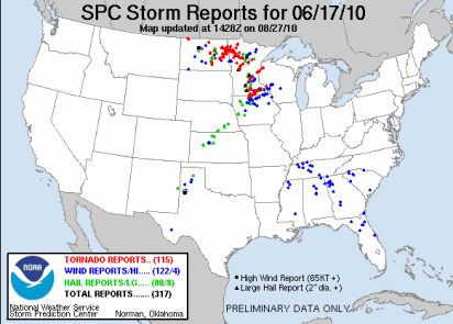
The top event on my list is the 48 tornadoes that touched down in Minnesota on June 17, 2010.
100617_rpts

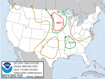
This would go down as the largest single day tornado outbreak in Minnesota history. Previously, 27 tornadoes occurred in the state on June 16, 1992. Most people many know that day for the F-5 tornado that struck Chandler, MN. The Storm Prediction Center noted that it could be a potentially dangerous day by highlighting most of Minnesota for a moderate risk of severe weather.
day1otlk_20100617_1200_prt

Forecasters warned that there could be significant tornadoes and that people stay tuned for the latest information.

PUBLIC SEVERE WEATHER OUTLOOK
NWS STORM PREDICTION CENTER NORMAN OK
1131 AM CDT THU JUN 17 2010

...SIGNIFICANT SEVERE THUNDERSTORMS EXPECTED OVER THE UPPER MISSISSIPPI VALLEY INTO PARTS OF THE MID MISSOURI VALLEY TODAY AND TONIGHT...

THE NWS STORM PREDICTION CENTER IN NORMAN OK IS FORECASTING THE DEVELOPMENT OF LARGE HAIL...DAMAGING WINDS AND A FEW TORNADOES OVER THE UPPER MISSISSIPPI VALLEY INTO PARTS OF THE MID MISSOURI VALLEY TODAY AND TONIGHT.

THE AREAS MOST LIKELY TO EXPERIENCE THIS ACTIVITY INCLUDE

MUCH OF IOWA
MUCH OF CENTRAL AND SOUTHERN MINNESOTA
FAR EASTERN NEBRASKA
FAR EASTERN SOUTH DAKOTA
FAR WEST-CENTRAL WISCONSIN

ELSEWHERE...SEVERE STORMS ARE ALSO POSSIBLE ACROSS THE NORTHERN PLAINS AND UPPER GREAT LAKES.

A POWERFUL UPPER-LEVEL STORM SYSTEM WILL MOVE EASTWARD TODAY ACROSS THE NORTHERN PLAINS...WHILE AN ASSOCIATED SURFACE LOW PRESSURE CENTER AND TRAILING COLD FRONT SHIFT EWD ACROSS THE DAKOTAS AND NEBRASKA INTO MINNESOTA AND IOWA. A WARM AND HUMID AIR MASS PRESENT AHEAD OF THIS STORM SYSTEM WILL FUEL SEVERE THUNDERSTORM DEVELOPMENT THIS AFTERNOON ALONG THE COLD FRONT INITIALLY OVER THE EASTERN DAKOTAS AND EASTERN NEBRASKA...WITH STORMS SUBSEQUENTLY DEVELOPING EAST INTO MINNESOTA...IOWA AND WISCONSIN THROUGH TONIGHT.

THE WARM/HUMID CONDITIONS IN CONJUNCTION WITH STRONG JET STREAM WINDS WILL FAVOR THE DEVELOPMENT OF INTENSE...SEVERE STORMS INCLUDING SUPERCELLS WITH THE THREAT FOR LARGE HAIL...A FEW TORNADOES --POSSIBLY STRONG-- AND DAMAGING WINDS. WITH TIME...STORMS MAY ORGANIZE INTO A LARGE COMPLEX WITH THE POTENTIAL FOR MORE WIDESPREAD DAMAGING WINDS SPREADING EAST ACROSS PARTS OF MINNESOTA AND IOWA INTO WESTERN WISCONSIN TONIGHT.

STATE AND LOCAL EMERGENCY MANAGERS ARE MONITORING THIS DEVELOPING SITUATION. THOSE IN THE THREATENED AREA ARE URGED TO REVIEW SEVERE WEATHER SAFETY RULES AND TO LISTEN TO RADIO...TELEVISION...AND NOAA WEATHER RADIO FOR POSSIBLE WATCHES...WARNINGS...AND STATEMENTS LATER TODAY.

Three EF-4 tornadoes touched down that day. Two in Otter Tail County, and one on Freeborn County. Three persons died, and there were 45 injuries reported.

image

One of the most devastated areas from these strong tornadoes was the town of Wadena, MN. Many homes were destroyed as well as the high school and stadium. Storm chaser video by Reed Timmer of the Wadena tornado, shot below.

2010 was a very active and memorable year as far as weather goes in Minnesota. How will 2011 turn out? We will eventually find out, but the record amounts of snow in December has me concerned about major spring time flooding. Forecasters are already concerned along the Red River for the potential of significant spring flooding. This blog will have you covered in 2011 for all things weather! I would also like to take this time to thank all my loyal readers who stopped by in 2010. It’s nice to know there is an audience for this kind of information and that it serves a helpful, useful purpose. If you know someone who might be interested in reading what I have to say, please pass on this blog’s link to them. All are welcome! Here’s to 2011. Cheers!

RS

Saturday, January 1, 2011

2010 Year in review from the National Weather Service in Chanhassen

WITH BLIZZARD CONDITIONS IN THE DAKOTAS AND NEARING WESTERN MN...TO TORNADO WARNINGS IN AL AND MS...AND A HARD FREEZE IN THE SOUTHERN AZ DESERT...IT WOULD SEEM 2011 IS IN LIKE A LION. AND 2010 WAS CERTAINLY A LION IN WEATHER ACROSS THE UPPER MIDWEST...BEING A STATISTICALLY IMPRESSIVE AND MAJOR IMPACTING YEAR. ANY METEOROLOGIST OR WEATHER ENTHUSIAST SHOULD TAKE JUST A MINUTE THIS NEW YEARS TO REFLECT ON THE NUMBERS AND MAGNITUDES OF THE EVENTS...THE ANOMALOUS NATURE OF PARAMETERS...AND THE RECORDS THAT WERE SHATTERED. FROM A SNOWLESS MARCH AND APRIL IN THE WARMEST SPRING ON RECORD...TO A RECORD SEVERE WEATHER SEASON THAT WAS DECEIVINGLY SLOW TO START BUT WOULD HOLD THE LARGEST TORNADO OUTBREAK IN MN RECORDED HISTORY...TO A SUMMER THAT WAS WARMER AND MOIST THAN MOST PROVIDING TWO INCH PWATS NINE TIMES AT MPX...TO A SEPTEMBER DELUGE AND SUBSEQUENT RIVER FLOOD...FOLLOWED BY A LOW PRESSURE BOMB BREAKING MN PRESSURE RECORDS...TO THE INCREDIBLE START OF THIS WINTER SEASON WHERE WINTER STORMS HAVE BEEN ON A CONVEYOR BELT INTO THE AREA...TO HALF TO THREE QUARTERS OF AN INCH OF RAIN ON DEC 30TH AND SLEET/HAIL/GRAUPEL AND THUNDER ON NEW YEARS EVE...2010 GAVE US EVENTS THAT WERE SOME OF THE MOST INTRIGUING AND IMPACTING IN THE NATION. ON MULTIPLE OCCASIONS THIS MADE MANY OF THE LONG TIME FORECASTING VETERANS HERE AT WFO MPX COMMENT THEY HAD NEVER SEEN THAT BEFORE...AND WE MAY NOT AGAIN. SO WHAT A WEATHER YEAR 2010 WAS.