Saturday, November 26, 2011

Warm Thanksgiving across Minnesota

It was an unusually warm Thanksgiving across much of Minnesota as many locations saw record high temperatures for the day.  Redwood Falls reached 66 degrees, just two degrees shy of the state record for the date of 68 degrees set at Wheaton in 1984.  It was also the fourth warmest Thanksgiving in Twin Cities history.

According to the MPR WeatherTalk blog, these locations across the state tied or broke records for November 24th:

  • 65 degrees, Canby
  • 64 degrees, Tracy
  • 61 degrees, Austin
  • 60 degrees, Rochester
  • 59 degrees (tied), Minneapolis-St. Paul
  • 57 degrees, Fargo-Moorhead
  • 55 degrees (tied), Detroit Lakes

Our Thanksgiving weather goes along with the theme this week of warm weather.  The week started off cool, but between November 23rd and November 25th (last three days), the Twin Cities is running almost 20 degrees above normal for high temperatures.  The trend is the same for much of southern Minnesota.  What season is it again?

MSPtemps7days

RS

Thursday, November 24, 2011

Happy Thanksgiving! Will it be a record setting one?

Happy Thanksgiving to everyone out there!  This post will look at the climatology on the day that we give thanks.

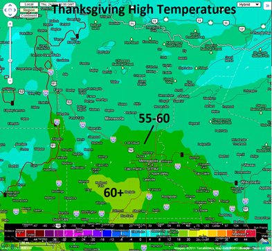
According to the Minnesota State Climatology Group, a typical Thanksgiving Day in the Twin Cities has high temperatures in the 30s, and at least a bit of filtered sunshine.  This year will atypical as high temperatures will be approaching 60 degrees in the Twin Cities!  I have little doubt that we will see temperatures in the 55 to 60 degree range with just a few high clouds in the area.  With last weekend’s snow pack pretty much gone, the sun’s energy will be used to warm the surface.  For now, I am going with a forecast of 59 degrees in the metro.  If this was to happen, it would tie the record for November 24th set in 1990.  The most recent mildest Thanksgiving happened in 1998 when the mercury hit 58 degrees in the Twin Cities.  As for the warmest Thanksgiving, it is 62 degrees, set in 1914, and later tied in 1922.

bufkitoverview

A Thanksgiving with temperatures above 50 degrees is a rare event in the Twin Cities as it has occurred just eight times since 1891.  Thursday’s setup will feature southerly winds pulling warm air into the Upper Midwest as the upper-level jet stream lifts into southern Ontario, Canada.  Some locations across far southern Minnesota will likely see 60 degree readings during the afternoon.

Eurotemps

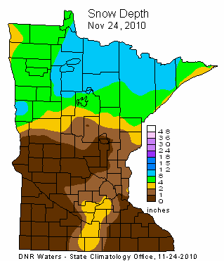
This time last year, there was little snow on the ground across the Twin Cities with the most in Scott County.  Across northern Minnesota, it was a different story as there was significant snow on the ground north of a Brainerd line.

Snow is commonplace across the state on Thanksgiving.  Historically, one in three Thanksgivings have at least one inch of snow on the ground.  In 1993, a Thanksgiving Day Blizzard affected central, western, and south central Minnesota, with heavy snow across most of Minnesota.  Over a foot of snow accumulated over west central Minnesota, and snowfall in excess of six inches or greater occurred north of a line from Bricelyn, in Faribault County, to the Twin Cities.  MSP picked up 4.3 inches of snow this day.

This could be one for the record books!  Enjoy your Thanksgiving with family and friends.

RS

Monday, November 21, 2011

Summary of November 19 snow

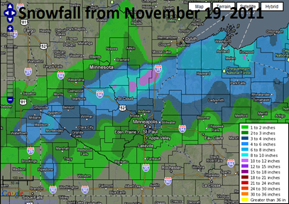
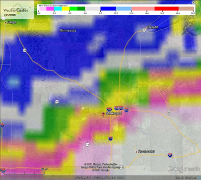
Here is a map and summary from the National Weather Service in Chanhassen of the snow that fell across southern Minnesota on November 19th.

snowfall11192011

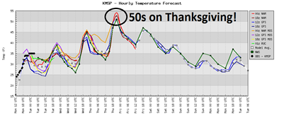
This snow will work against temperatures from increasing too much over the couple days, but by Thanksgiving we could be looking at 50 degree weather around the Twin Cities.

Thanksgivingforecast

RS

Saturday, November 19, 2011

Snow ending and totals from Saturday

The heaviest of the snow has ended across the state and some totals are starting to come in from the first measurable snow for much of Minnesota.  Locally, I received 2.3 inches of snow in Shakopee, which was not yet reflected on this report at the time it was created.

Here are the reports:

snowfall11192011

INCHES  LOCATION         ST  COUNTY         TIME
------ --------------- -- ------------- -------
11.00 ST STEPHEN MN STEARNS 0413 PM
11.00 2 N SARTELL MN STEARNS 0407 PM
7.00 SAUK RAPIDS MN BENTON 0343 PM
7.00 BELGRADE MN STEARNS 0157 PM
6.60 7 S HILLMAN MN MORRISON 0248 PM
6.50 MILACA MN MILLE LACS 0517 PM
6.30 2 W FOLEY MN BENTON 0537 PM
6.00 SAUK RAPIDS MN BENTON 0430 PM
6.00 STARBUCK MN POPE 0207 PM
5.80 ST CLOUD MN STEARNS 0500 PM
5.60 MURDOCK MN SWIFT 0332 PM
5.50 11 NE WARMAN MN KANABEC 0630 PM
5.50 2 W FOLEY MN BENTON 0359 PM
5.50 SARTELL MN STEARNS 0257 PM
5.00 RICE MN BENTON 1226 PM
4.00 NORTH BRANCH MN CHISAGO 0623 PM
4.00 STARBUCK MN POPE 0129 PM
3.50 ST CLOUD MN STEARNS 0600 PM
3.50 KIMBALL MN STEARNS 0417 PM
3.20 WOODBURY MN WASHINGTON 0500 PM
3.00 ISANTI MN ISANTI 0635 PM
3.00 MINNEAPOLIS MN HENNEPIN 0553 PM
3.00 ST AUGUSTA MN STEARNS 0321 PM
3.00 6 W BELLINGHAM MN LAC QUI PARLE 1215 PM
3.00 SAUK CENTRE MN STEARNS 1030 AM
2.80 PRINSBURG MN KANDIYOHI 0358 PM
2.50 INVER GROVE HEI MN DAKOTA 0537 PM
2.50 MILACA MN MILLE LACS 0139 PM
2.50 LOUISBURG MN LAC QUI PARLE 0936 AM
2.20 LONG PRAIRIE MN TODD 0612 PM
2.20 5 SW ST PAUL MN RAMSEY 0600 PM
2.10 NORTH ST PAUL MN RAMSEY 0542 PM
2.00 ISANTI MN ISANTI 0413 PM
1.80 2 W PRIOR LAKE MN SCOTT 0545 PM
1.80 SARTELL MN STEARNS 1212 PM
1.70 CHANHASSEN MN CARVER 0542 PM
1.50 2 S RICE LAKE WI BARRON 0259 PM
1.50 BURNSVILLE MN DAKOTA 0257 PM
1.30 COMFREY MN BROWN 0445 PM
1.00 FARMINGTON MN DAKOTA 0543 PM
1.00 FARMINGTON MN DAKOTA 0537 PM
1.00 LITTLE CANADA MN RAMSEY 0255 PM
0.50 WINTHROP MN SIBLEY 0607 PM
0.50 MADELIA MN WATONWAN 0554 PM
0.50 MANKATO MN BLUE EARTH 0407 PM
0.50 BENSON MN SWIFT 0936 AM


RS

The snow has arrived

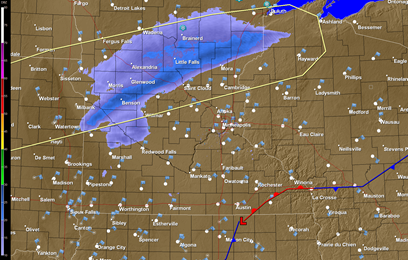
Snow had begun falling across the western and north central parts of Minnesota during the morning hours.  Louisburg, near the Minnesota and South Dakota border, has received two and a half inches of snow as of 9:35 AM.  The area highlighted in yellow below is where the heaviest snow band will set up today.  Snowfall rates may reach one inch per hour at times as the low pressure area tracks through the southeast corner of Minnesota.

AMradar11192011

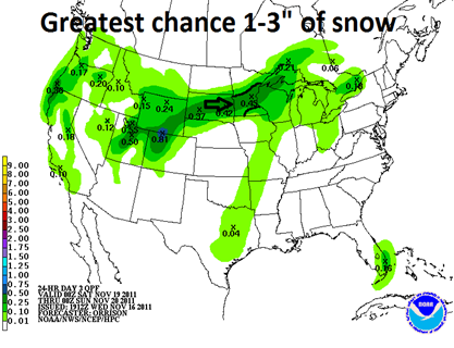
Here are my projections for snow totals from this storm across the state.  I’m favoring the GFS for location and amounts with this snow.  One to two inches across the Twin Cities, two to three across central Minnesota and northeastward into Duluth, and the heavy snow occurring across far western Minnesota where as much as four inches may fall.

GFS1119201100z

RS

Wednesday, November 16, 2011

Weekend snow update

An update to the first measureable snow of the season that will impact areas of central and south central Minnesota during the weekend…

Over the last couple days, the forecast models have been shifting in different directions with the approaching low pressure area.  The consistent trend that I have seen is that snow will fall across the central part of the state from St. Cloud to Brainerd to Duluth.  The big question has been the impacts of the storm across the Twin Cities.  The rain/snow dividing line is setting up to be very close to the metro.  My current thinking is that the Twin Cities will see rain to start the day on Saturday, before changing over to snow Saturday night, based on the NAM temperature profiles.  Areas to the north will see snow the majority of the day. 

Based on my calculations, I’m expecting about a slushy inch of snow across the metro, and south to Mankato and Owatonna, while areas that see most of the snow could pick up as much as three inches.  This will be a wet and heavy snow with snow ratios in the 5:1-8:1 range.

QPF11202011

RS

Tuesday, November 15, 2011

Snow this weekend? A close call for the Twin Cities metro

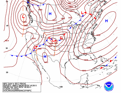
A low pressure area is expected to track northeastward that will bring a chance of snow across central Minnesota this weekend.  The timing right now appears to be late Saturday into Sunday.

9lhwbgfnl_conus

The cutoff for accumulating snow is setting up to be be right over the Twin Cities metro according to the GFS and European forecast models.  It possible that some places across central Minnesota could pick up a half of foot of snow or more.  It still a bit early to give exact snowfall estimates as the projected storm track may still shift between now and the weekend.  Wouldn’t be surprised to see a dusting of snow across the Twin Cities, especially the northern suburbs.

GFS:

snow11202011GFS

European:

snow11202011euro

Something to watch that may have an impact on weekend travel.  Stay tuned!

RS

Look back at the November 13, 2010 snow storm

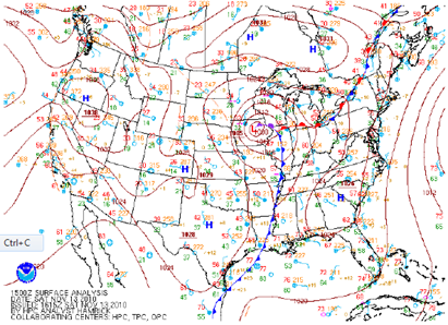
A little over a year ago today, the Twin Cities saw it’s first significant snowfall of the 2010-11 season from a low pressure system that developed across the southern United States, and moved from a northern Missouri to western Wisconsin position between the 12th and 14th of November.  The track was one of a “Panhandle Hooker”.  No, it’s not a dirty term - rather it’s a system that develops over the panhandle of Texas and Oklahoma.  This was the largest pre-Thanksgiving snowfall for the Twin Cities since the Halloween Blizzard of 1991.

image

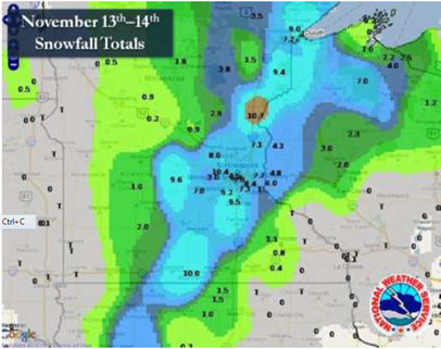
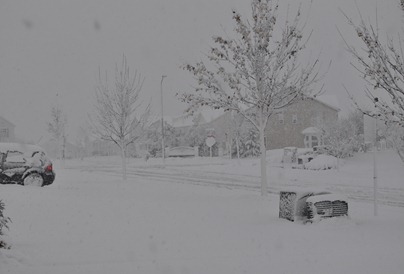
As I recall from a blog entry at the time, there was roughly a 48-hour advanced warning with this system as winter storm watches were issued on the 11th.  The snow would begin late on the night of the 12th, and persist through the day on the 13th for much of central and southern Minnesota into northwestern Wisconsin.  The snow ended in northeast Minnesota on the 14th.  This storm left a blanket of snow about 100 miles wide from western Iowa, though south central Minnesota, and into the Arrowhead of Minnesota.  The snow was wet and heavy from having a high moisture content level.  It caused tree branches to snap, and resulted in power outages.  Thunder and lightning accompanied the storm, and was observed across southern and eastern Minnesota during morning hours of the 13th.

image

The highest snow total reported in Minnesota was 12 inches near Maple Grove in Hennepin County. The National Weather Service Office in Duluth saw 10.6 inches.  At Twin Cities International Airport, as well as my location in Shakopee, 8 inches of snow fell.  Of the 8 inches at the airport, 7.7 inches was recorded on the 13th.

446652237

Additional reading:

RS

Thursday, November 10, 2011

First snow recorded of the season in the Twin Cities

MSP finally recorded it’s first snow of the season Wednesday night as a trace of snow fell.  It was repeated with another trace of snow Thursday morning.  No measureable snow has fallen so far this season.

The next chance of any flurries is Sunday morning.  Looking ahead, there are no major storms in sight through Thanksgiving for now.

snowflake_clipart

RS

Tuesday, November 8, 2011

Tuesday snow storm update

A Winter Storm Watch has been issued from 6:00 PM CST Tuesday until 12:00 PM CST Wednesday for the following counties across Minnesota: Dodge, Fillmore, Houston, Mower, Olmsted, Wabasha, and Winona.  The National Weather Service says six or more inches is possible in the watch area.

winterwatch

The storm system will move into southern Wisconsin by Wednesday with cold air, near freezing, wrapping into the moisture transport from the Gulf of Mexico.  This will set the stage for snow behind the system across southeast Minnesota, and a good portion of Wisconsin.

surface low

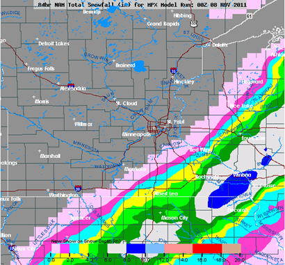
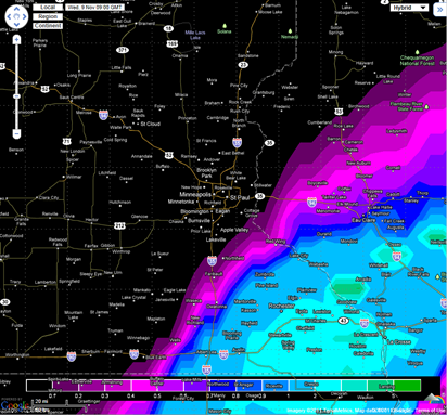
For forecasted snowfall totals, I am going on a blend of the NAM and European models.

NAM snowfall output:

NAMsnow

European snowfall output:

Euro0800z

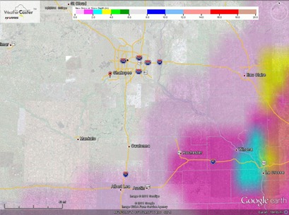
Snow flurries may be mixed in with rain showers across the far southeastern corner of the Twin Cities metro, Dakota County in particular, by the morning on Wednesday, but the heaviest snow will be located across southeast Minnesota into Wisconsin. It appears areas from Red Wing to Rochester will see one to three inches of snow, while Rochester to La Crosse, Wisconsin will see larger amounts in the three to six inch range.  Enough to shovel, and perhaps some early season work for the snow blowers!

RS

Monday, November 7, 2011

Monday morning update on midweek storm

With the latest forecast model runs, we are starting to see more agreement for the projected track of the storm system that is expected to arrive late Tuesday into the first half of the day Wednesday.

Both the GFS and European models put the snow line starting roughly at Red Wing, Minnesota.  Rochester could see a couple inches of snow, while places such as Winona and La Crosse, Wisconsin could pick up close to five inches of snow.  Enough to shovel.  The Twin Cities could see some flurries mixed with rain showers, but nothing significant.

The GFS model storm track:

GFS0700z

The Euro model storm track:

Euro0700z

Across southeast Minnesota, the available moisture that the storm will have to work with will be good for producing snow.  No dry layers of air are shown towards the surface.

bufkitoverview

RS

Sunday, November 6, 2011

Sunday update on midweek storm

Just a quick update on the midweek storm system that may bring snow and rain to the area…

Part of the challenge is that there is no agreement between the forecast models.  The American models (GFS and NAM) want to steer the storm track east over the Great Lakes region.  The European and Canadian models want to take the track over southeast Minnesota.  Another factor is the rain/snow line, and how close will it setup to the Twin Cities metro area.

My current thinking is to keep the snow southeast of the Twin Cities into southeast Minnesota.  Analyzing the dynamics, I’m not real impressed with the snow making ability of this system.  Rochester is in line to pick up a coating to two inches of snow on the backside of the low pressure system.  This accumulated snowfall image through Wednesday night summarizes how I see the event unfolding.

accumsnow

RS

Saturday, November 5, 2011

Thoughts on next week’s storm system

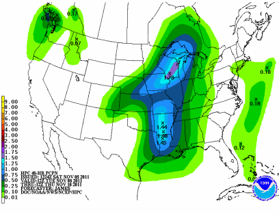
As early as Thursday morning, forecast models began to pick up on a low pressure system tracking across across the Upper Midwest from the southwest on Tuesday and Wednesday.  Watching the various model runs over the last couple days, it’s appearing more likely that the low track will be to our east, across Wisconsin.

9lhwbgfnl_conus

As it tracks across the region, it is expected to tap into Gulf of Mexico moisture to bring some respectable precipitation.  At this time, it looks like Wisconsin will see the brunt of the storm.

95e12p48iwbg_fill

The rain/snow line may just cut through the southeastern Twin Cities metro.  Right now, it appears that most of the precipitation will fall as rain from Rochester, MN to southern Wisconsin, but north central Wisconsin could see some snow out of this system.  If the low tracks to the slightest bit to the west from an east coast ridge block, then I do think the Twin Cities could see a snow/rain mixture or snow out of this system. If it is all snow, then we could end up with one to two inches.

CONUS_GFS_1000-500_SLPPRPTHK_90HR

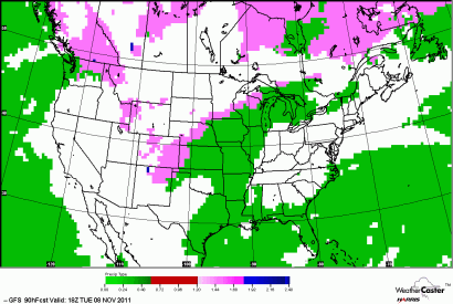
The snow (magenta)/rain (green) “battle field” sets up across Minnesota:

CONUS_GFS0P5_SFC_PTYPE_90HR

For now, you’ll probably be keeping the snowblowers in the garage, but stay tuned for updates on this system!

RS

Wednesday, November 2, 2011

October weather summary and November outlook

October continued the warm and dry trend that has been ongoing since August.  The average temperature in the Twin Cities during the month was 55.4 degrees, and was 6.5 degrees above normal.  It tied for the seventh warmest October on record.  While the month finished with near normal temperatures, the first half of the month was well above normal.

Other locations in Minnesota, such as St. Cloud, was 5.3 degrees above normal for the month with an average temperature of 51 degrees.  At Rochester, the average was 53 degrees, and 4.6 degrees above normal.  Duluth saw 48.5 degrees for an average temperature, and 5.3 degrees above normal.  Here is a look at temperature trends compared to average from around the state:

As far as precipitation, the Twin Cities saw just seven tenths of an inch of rain, which is 1.73 inches below normal.  On an annual basis, total precipitation is at 25.62 inches, and 2.12 inches below normal.

St. Cloud saw a bit more rain during the month with 1.42 inches of rain, which is 1.07 inches below normal.  Rochester received .29 inches of precipitation, which was 1.95 inches below normal.  It was the 5th driest October on record there.  In Duluth, the city picked up 1.13 inches of precipitation, and was 1.72 inches below normal.  Here is a look across Minnesota showing the percentage of normal amount of precipitation picked up.  One would have to travel towards the international border just to find near normal monthly rainfall.

This lack of moisture has contributed to the drought that began towards the end of August.  Since July 26th, most of the state has seen a deficit in liquid.

Southern Minnesota and areas across the Arrowhead of Minnesota are now classified as in a “severe” drought.

mn_dm

The outlook for November appears to be a broken record.  The Climate Prediction Center is indicating chances of above normal temperatures during the month through much of the middle section of the country.

off15_temp

Precipitation chances are bit more uncertain as there is equal probabilities of average, above, or below normal situations.

off15_prcp

It will be interesting to see how the month plays out, but early indications are it will be quite dry through at least the middle of the month. The long range models are not printing out any big storms for the Twin Cities, and temperatures do look to be mild during this time.  The average temperature for November is 42 degrees and average precipitation is six hundredths of an inch.

RS