Wednesday, May 30, 2012

Why the outdoor siren policy needs to change

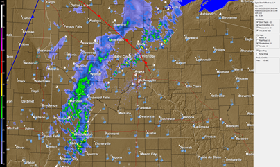
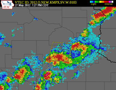
Sunday night, a severe thunderstorm moved through the southwest metro, triggering the outdoor sirens to sound in communities from Shakopee to Minneapolis.

radmap_1927_05272012

Because it was a severe thunderstorm warning, there was confusion as to why the sirens were going off.  I had wrapped up storm chasing for the day, and was on the road heading out of town to visit my girlfriend for the remainder of the Memorial Day weekend.  Therefore, I could not do a lot of digging into “sirengate” at the time.

tweetsirens_1

Shakopee mayor, Brad Tabke, asked the Scott County Sheriff’s Office about the policy for the sirens, and was told it was because of the National Weather Service warning of 70 mph winds.  The issue is that this policy is not clearly stated anywhere.  My search of the Scott County website turned up nothing.  All I could find was vague criteria of “high winds” found elsewhere on the web.

tweetsirens_3

The Scott County Sheriff’s Office was correct with their information as the initial warning from the National Weather Service did include text of destructive winds in excess of 70 mph.

BULLETIN - IMMEDIATE BROADCAST REQUESTED
SEVERE THUNDERSTORM WARNING
NATIONAL WEATHER SERVICE TWIN CITIES/CHANHASSEN MN 727 PM CDT SUN MAY 27 2012

THE NATIONAL WEATHER SERVICE IN THE TWIN CITIES HAS ISSUED A

* SEVERE THUNDERSTORM WARNING FOR...
SOUTHEASTERN CARVER COUNTY IN EAST CENTRAL MINNESOTA...
SOUTHERN HENNEPIN COUNTY IN EAST CENTRAL MINNESOTA...
CENTRAL SCOTT COUNTY IN EAST CENTRAL MINNESOTA...

* UNTIL 815 PM CDT

* AT 721 PM CDT...TRAINED SPOTTERS REPORTED A SEVERE THUNDERSTORM WITH QUARTER SIZE HAIL AND DESTRUCTIVE WINDS IN EXCESS OF 70 MPH. THIS STORM WAS LOCATED NEAR JORDAN...OR ABOUT 20 MILES NORTHEAST OF LE SUEUR...AND MOVING NORTH AT 25 MPH.

While I do agree Scott County acted properly with the sirens in this situation as winds with this event were near or at hurricane force, this event really got me thinking that it is time to reform the outdoor siren system in state.  It varies from county to county.  Rusty Dawkins, chief met at KAAL-TV in Austin, MN was kind enough to share when sirens sound in southern Minnesota.  I believe it is time to adopt a uniform policy for the sirens during severe weather.  Dakota County uses them for any severe thunderstorm warning.  Having never lived in Dakota County, I asked if the sirens are effective when activated during every severe thunderstorm in the county.  Here some of the responses received.  Many current and former residents expressed their disapproval.

ralphtweet1ralphtweet2

christweet1

neiltweet1

toddtweet1

robtweet1

A uniform policy should be one that simple and concise for the public to remember.  The information should be right at your fingertips - it should not have to take a tweet during severe weather to get an explanation for the siren activation.  Here is what I propose for consistency across the state:

  • Severe thunderstorms with winds 70 mph or greater
  • Tornado warnings

That’s it.  Simple, easy to remember.  The sirens would sound for only the most severe of storms, avoiding the “cry wolf” mentality.  This information should also be shared during severe weather awareness week each year as a reminder.  I’m a firm believer in the KISS principle and common sense, and I think it’s time for the state to take a long and serious look at reforming the outdoor sirens during severe thunderstorms.

RS
Sunday, May 27, 2012

Timing of the severe weather threat

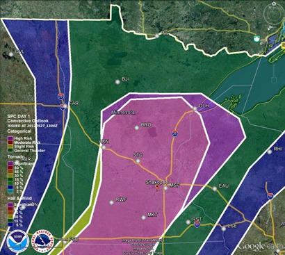
A lifting warm front and an advancing cold front will set the stage today for severe thunderstorms as temperatures reach the 90s across the southern two-thirds of Minnesota and tropical dew points near 70.

analysis_05272012

Large hail and damaging winds will be the greatest threats from any storm.  The tornado risk is low due to unidirectional wind from the surface to upper-levels of the atmosphere.

Significant hail threat today:

hailoutlook_052712

Wind threat:

windoutlook_052712

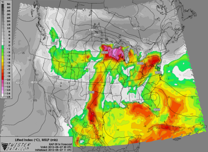
The hot temperatures along with the moisture in the area will be create a strongly unstable environment by the evening hours after peak daytime heating.  CAPE values near 3,000 J/kg and a lifted index around –10 will provide more than enough “juice” and lift to produce isolated to widely scattered severe thunderstorms during the latter part of the day.

CAPE:

RAP_255_2012052711_F09_CAPE_SURFACE

Lifted Index:

RAP_255_2012052711_F09_LFTX_500_1000_MB

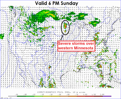
As far as timing of the storms today, the forecast models seems to be all over the place, but I am favoring the thunderstorm activity to move through the Twin Cities late tonight into the early overnight hours.  Right now it appears storms will fire after 6 p.m. across western Minnesota, then slowly progress eastward towards the Twin Cities after nightfall.  The Twin Cities will be impacted sometime between 11 p.m. and 1 a.m.

today_1h_f23_052712

1ref_t2sfc_f13_052712

rad22_052712

Euro_052712_06z

Stay safe today if you have any outdoor plans, especially late in the day, then keep it tuned to Stormchaserschwartz.com and StormChaser Schwartz social media outlets for additional information today!

RS

Friday, May 25, 2012

Rainfall totals over the last two days

Wednesday and Thursday brought heavy rainfalls across a good portion of central and eastern Minnesota.  When the rain finally ended, it felt as if it had rained for 24 hours straight!

A swath of three to five inches of rain fell across western sections of the Twin Cities metro and areas to the southwest and northeast.  Officially, MSP Airport picked up 3.39 inches over the two days.  The 2.58 inches the airport received on Thursday set a new daily record for May 24.  The old record was 1.27 inches set May 24, 1937.

rainfall_05252012

Here are some reports of rainfall in excess of three inches from the National Weather Service in Chanhassen:

Wright County:

  • POWER PLANT (Monticello) 515 PM MAY 24 - 4.03 IN
  • 1 W HOWARD LAKE 444 PM MAY 24 - 3.19 IN

Sherburne County:

  • 1 N ZIMMERMAN 403 PM MAY 24 - 5.50 IN

Scott County:

  • 1 NW SHAKOPEE 351 PM MAY 24 - 3.22 IN

Ramsey County:

  • 1 S NORTH SAINT PAUL 541 PM MAY 24 - 4.05 IN
  • ROSEVILLE 600 PM MAY 24 - 3.30 IN

Hennepin County:

  • 2 NW LORETTO 523 PM MAY 24 - 3.94 IN
  • 1 W BROOKLYN PARK 604 PM MAY 24 - 3.88 IN
  • 3 NNE RICHFIELD 619 PM MAY 24 - 3.17 IN
  • 1 WSW THE LAKE MINNETONK 430 PM MAY 24 - 3.02 IN

Chisago County:

  • 2 N NORTH BRANCH 550 PM MAY 24 - 4.00 IN
  • 8 ENE BRANCH 600 PM MAY 24 - 3.42 IN
  • 3 NNE SCANDIA 604 PM MAY 24 - 3.15 IN

Carver County:

  • 1 ESE WATERTOWN 424 PM MAY 24 - 4.28 IN
  • 3 S CARVER 549 PM MAY 24 - 3.08 IN

Anoka County:

  • 1 S SAINT FRANCIS 433 PM MAY 24 - 4.68 IN
  • 2 SE ANOKA 458 PM MAY 24 - 3.58 IN
  • 6 WSW WYOMING 606 PM MAY 24 - 3.53 IN

RS

Wednesday, May 23, 2012

Active pattern ahead for Memorial Day weekend

A cold front will move through the state today that will dump heavy rains across Minnesota.

94fwbgus

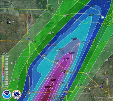
The front is expected to stall near the Twin Cities during the overnight which will be the focal point for all the rainfall.  Some places near the Twin Cities and southwest could see upwards of two inches of rain today.

rainfall_05232012

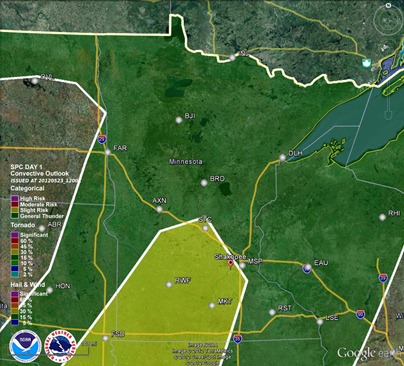
The Storm Prediction Center has issued a slight risk of severe thunderstorms from the Twin Cities to southwest Minnesota, however I think the rains will be the bigger story.  There might be a few stronger storms, but the overall severe weather threat is pretty marginal today.  The lack of rich Gulf moisture and the upper-level wind setup is not favorable for severe storms.

svroutlook_05232012

Cloud cover and morning rain is ongoing across the state.  This will be the theme throughout the day.

g13_2012144_1232_smDLH_vis

radar_05232012_730

The heavy rain is expected to push make it’s way into the Twin Cities after 8 p.m. tonight, according to a couple of the high resolution forecast models.  Some of the storms across southwest Minnesota may be strong.

today_1h_f26

RPM_05232012

Thursday, Saturday, and Sunday is looking like much of the same.  There will also be the possibility of severe thunderstorms on Sunday.  Stay tuned for further developments on this weekend’s weather!

RS

Tuesday, May 22, 2012

Minneapolis tornado: One year later

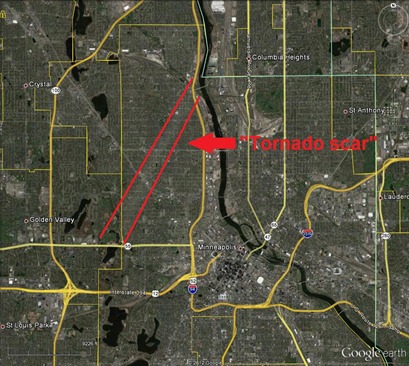
On Sunday, May 22, 2011, an EF-1 tornado tore through western and northern sections of Minneapolis.  There was one fatality in north Minneapolis.  The majority of the damage came from fallen trees on top of vehicles and roofs, but in some cases the wind was strong enough to lift entire roofs off of structures.  On the same day, an EF-5 tornado leveled Joplin, Missouri, resulting in 158 deaths and over 1,000 injured.  In retrospect, Minneapolis got off easy this day.  While the Minneapolis twister traveled 6.25 miles mainly over residential areas causing structural damage to homes, the Joplin tornado wiped the surface clean of any structures.

Recent Google satellite imagery shows the scar left behind from the Minneapolis tornado.  It began near the Theo Wirth Park area, where I surveyed the aftermath on this Sunday afternoon.

MplsTornadoGoogleMap

A closer look at the damage path reveals residences with blue tarp, indicating rooftops in disrepair.

roofdamage

Now take a look at the Joplin damage.  Entire subdivisions of the city gone!  Everything is unrecognizable.

joplindamage

With all the attention the anniversary of the Minneapolis tornado will receive from media outlets, I feel it is important to put the impacts of the tornado in perspective.  We were lucky compared to other areas of the United States on May 22, 2011, and during that year in general - Alabama was hit very hard by a tornado outbreak in April 2011.  The damage in those locations was catastrophic, and it will take many years for them to rebuild from scratch.

RS

Monday, May 21, 2012

05.01.12 Carver/McLeod County, MN

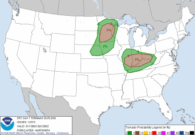
A severe weather setup was unfolding for May Day.  Leading up to this day, I had discussed the dynamics in play that would aid in thunderstorm development.  The Storm Prediction Center morning outlook indicated the possibility for tornadoes across a wide area of central Minnesota.

day1otlk_20120501_1300_prt

day1probotlk_20120501_1300_torn_prt

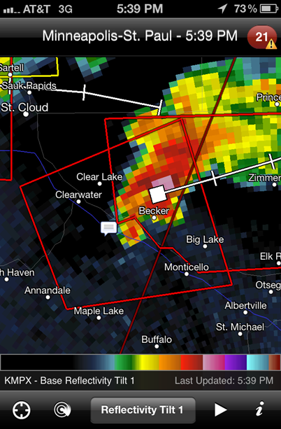
Thunderstorms began to blossom just northeast of the metro before 5 PM:

038

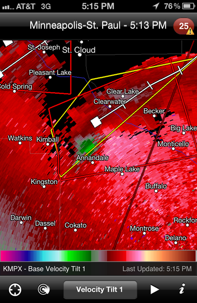
The storms would go tornado warned towards 5 PM with strong rotation picked up by radar near the Annandale and Becker areas.  However, no tornadoes were reported with this cell.

040

041

A line of storms was moving in from the west.  I decided to chase these storms heading into McLeod County around 7 PM.

radar_050112_zoom

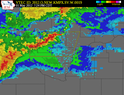
The cell in McLeod County went severe thunderstorm warned at 7:24 PM:

radmap_0724_05012012

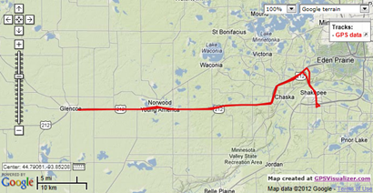
I made it into Glencoe around 7:45 PM.  Did not witness any severe weather here.  Just some heavy rains and vivid lightning.

001003005

After spending time in Glencoe, I drifted east to Norwood-Young America to catch the storms if they happened to strengthen.  It was quite the opposite.  The system weakened as it moved closer to the Twin Cities metro.

MPX_N0R_1205020158_1280x960_none__173_an

Here is a chase summary video of this chase.  I pieced together time lapses of the captured footage.

Severe weather was confined to central and southwestern Minnesota this day.  Hail was the greatest threat, but three tornadoes were reported across the west central part of the state.

lsr_05012012

Chase log from this day:

gpslog_050112

RS
Friday, May 11, 2012

Drought be gone

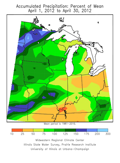
Since the middle of April, we have seen our fair share of rain across the Twin Cities and much of Minnesota.  Lately, Saturday seems to be the popular day for resorting to indoor plans.  Just over three inches of rain fell in April in the Twin Cities, which was .38 inch above normal.

Aprilraintotal

The southeastern two-thirds of Minnesota saw precipitation close to normal, while northwestern parts of the state received one and a half to two times as much water for a typical April.

m04_12_pperc

We have seen more rain in May already than all of April.  So far, the Twin Cities has picked up 4.29 inches of rain, pushing monthly totals well above normal by 3.3 inches

Mayraintotals

The southern half of the Twin Cities has really seen the precipitation since April 1.  Some locales in Scott and Dakota Counties have seen over four inches of rain this month.  Southeastern Scott County near Elko, and the Pipestone area in southwest Minnesota have seen over five inches of rain.

p20120401-20120507d_bigger

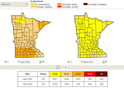
Mother Nature always has a tendency to balance things out over time.  It is this equilibrium that allows for human life on this planet.  At the start of April, much of southern Minnesota was in a severe drought.  With the recent rains, the severe drought conditions have been virtually eliminated.

droughtcompare

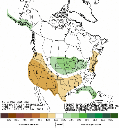
The short-range outlook from the Climate Prediction Center indicates more wet weather across the Upper Midwest to about Memorial Day.

814prcp_new

How long will the rainy pattern last?  Right now it’s hard to say.  Perhaps we will dry out sometime this summer.  As I mentioned earlier, it is all a balancing act when it comes to the weather!

RS

Monday, May 7, 2012

05.02.12 Medford, Minnesota

Another active thunderstorm day was upon us as a frontal boundary positioned itself across the central part of Minnesota on Wednesday, May 2nd.  This would be the focal point for severe thunderstorms.

usfntsfc2012050221

The Storm Prediction Center outlined southern Minnesota in an area of a slight risk for severe thunderstorms in their 7:35 AM (all times are CDT) outlook:

day1otlk_20120502_1300_prt

From the SPC forecast discussion:

SUFFICIENT WESTERLY FLOW ALOFT WILL PROMOTE SUPERCELL STORM STRUCTURES CAPABLE OF VERY LARGE HAIL...DAMAGING WINDS...AND A ISOLATED TORNADOES.

By the late afternoon, storms began to fire south of the Twin Cities area, affecting Mankato, and tracked eastward towards Interstate 35 around Faribault and Owatonna.  This radar image below is from 6:42 PM CDT, which depicts a merger of two cells in the Mankato area.  This was about the same time I made the decision to attempt and intercept of this cell near the interstate at Faribault.

MPX_N0R_1205022342_800x600_KFBL__0865

As I got to Faribault, I decided to head a bit further south towards the town of Medford to get into better position for seeing something interesting out of this cell.  I traveled west of Medford on Steele County Road 12 and then north on Steele County Road 11/72, stopping to take some photos at 7:25 PM.  I found myself on the outflow side of the storm as strong winds were rushing against the side of the car.  I did not have my anemometer set up on the car rooftop, but I estimated the winds to be around 30 to 40 miles per hour at that time.

001

002

The cell appeared to begin to show a hook echo at 7:28 PM when this radar image was taken with my location noted.  I found myself to be right in the belly of the beast.  Normally, I like to be at least a mile out from the storm for safety reasons and to get a wider perspective of the storm structure, and usually I am pretty good about watching myself.  Perhaps I was a bit gung-ho on my hopes of finally seeing a tornado.  It was a little too close for my comfort level.  Something that I will take from this chase was a learning experience on positioning.  The center of circulation was also passing a couple hundred yards north of County Road 12, so I could have been driving right into a potential tornado had I not turned onto a side road before the circulation and I crossed paths.  It was like some force was telling me to get out of the way of this monster.

MPXbaseradar_050312_002834

At 7:28 PM, the greatest area of rotation was closer to Interstate 35.  However, it was too close to Medford for my liking.  NEVER do I want to see a populated area directly in the path of a potentially tornadic system.  Being a storm chaser is a double-edged sword.  Every chaser wants to see good storms, but a the same time, hoping they do not affect where people live.

MPXvelocityradar_050312_002834

The cell went tornado warned at 7:32 PM.  I found myself on the southern extent of the warning polygon heading back towards the freeway.  No tornado was ever spotted in the warning area, which was a good thing considering the towns and cities that dot the interstate, as well as travelers on the freeway.

tornado_warning_050312

Here is a radar loop of the cell as it crossed Interstate 35 and headed towards southeastern Minnesota.  Once the storm crossed the interstate to the east around 7:40 PM, I decided to call it a day. The supercell characteristics were quickly diminishing and it transformed into a heavy rain and large hail producer.  I also had some items at home to take care of before the day was over, so I could not stay all night.

MPX_N0R_1205030128_800x600_KFBL__0865_an

Here a chase summary of the mesocyclone near Medford:

No tornadoes were reported this day, but it dropped quite a bit of large hail along a 135 mile path across southern Minnesota:

lsr_05022012

This was a nice chase being able to cruise down I-35 to catch up with the storms pretty quickly without dealing with a lot of traffic or figuring out back roads to get to the storm.

gpslog_050312

Total reports: None

RS