Saturday, March 30, 2013

Play Ball!

The Minnesota Twins take the field to open the 2013 MLB season on Monday, April 1st, against reigning American League Champion Detroit Tigers.  This season will mark the earliest outdoor home opener for the team since their arrival to Minnesota in 1961.

After this season, Major League Baseball may have to reconsider scheduling teams in the northern states to open the season at home.  It is going to be downright chilly!  No other way to put it.   While the game is scheduled for April Fool’s, this is no joke.  I consulted with the trusted European model from the overnight run, and it keep temperatures in the 30s around 4 PM Monday.

Euro_TwinsOpener

Some of the mid-morning North American model runs are suggesting that temps will not even make it into the 30s.  However, the models have a tendency to not perform well during seasonal transition periods, so it is possible this data is inaccurate (garbage in = garbage out).  I think low 30s for highs seems likely at this point, about 32 degrees.  Since the Twins have been playing outdoors, the coldest high temperature for opening day was 34 degrees on April 14, 1962.  In fact, that is the only other time the temperature was in the 30s for an outdoor home opener.  If you are attending the game Monday, the moral of the story is keep your winter attire out for at least one more day.  One of these days, you will be able to store it in the closet until next winter.

RS

Wednesday, March 20, 2013

Welcome to Spring…kinda

March Madness

Believe it or not, spring begins at 6:02 AM Central Standard Time!  It certainly will not feel like it, as temperatures start off in the single digits in the morning with wind chill a factor.  Spring has not started this cold since 1965, when the temperature reached a high of 15 degrees in the Twin Cities on March 20 of that year.  Contrast this to the very mild March we had in 2012, where it felt like summer at times with temperatures into the 80s.  With the warm air mass last year came severe weather, as an early tornado occurred on March 19, south of the Twin Cities metro.  Nonetheless, the drastic swing between the two years has made the natives restless, and a particular weather-predicting rodent very unpopular.

45176_10151478860023286_1991886633_n

881962_526067740765603_110529875_o

March started unseasonably chilly as high temperatures are running 20 degrees below normal. Yes, 20, that is not a typo!  We have only reached at or above average for a maximum daily temperature four times this month.

MarTemps_MSP_03202013

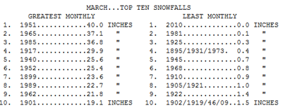
In addition to the cold, it has also been a snowy month as we have reached 13.8 inches of snow for the month – a March surplus of 6.4 inches.  The previous weather system dropped 3.1 inches of snow officially at Minneapolis/St. Paul International Airport.

MarSnows

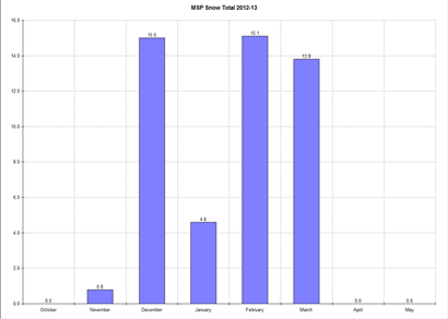
For the season, we have received 49.3 inches of snow. That is around normal for the season - just two tenths above.  Between December, February, and March it has been a pretty even distribution of snow.  February reigns supreme when it comes to most snow with 15.1 inches, but December was right behind, checking in at 15.0 inches.

MSP snow total

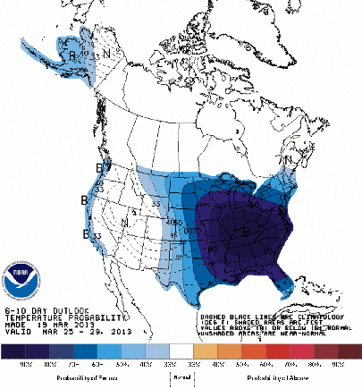
Unfortunately, the rest of March is looking ugly as I alluded to in my video blog.  Below normal temperatures will continue right through the end of the month.  Snow chances return to Minnesota early next week, and the potential is there for at least another couple inches.  I don’t think we will have to worry about any early severe thunderstorm outbreaks this year.

610temp_new

The extended cold snap will also make it difficult to melt away at the snow pack.  North and west of the Twin Cities lies well over a foot of snow.  Roughly two-thirds of the state has this much on the ground right now.  I am concerned about rapid snow melt and the potential for flooding affecting some parts of the state this spring.

snoedepth_032013

When will spring finally arrive?  Only time will tell, but my hunch is that it will be sometime in April.  We can not stay in this pattern forever.

RS

Sunday, March 17, 2013

Weather briefing of upcoming Winter storm

Here is a video blog I created discussing the upcoming winter storm to impact the state.  More of a practice run to get a feel for video blogging.  Let me know if this is medium for presenting information.

RS

Tuesday, March 12, 2013

Where is Spring?

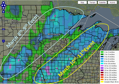
A lot of Minnesotans are wondering where spring-like weather is now that we are into the month of March.  So far this month, we have seen a few snow events across the state, dumping a half-foot or more at one time to some parts.  The Twin Cities saw heavy snow on March 4th and 5th, and northern and southeastern Minnesota were on the receiving end March 8th and 9th, and 10th and 11th, respectively.
Regional72HourMap

As for temperatures, high temperatures in the Twin Cities are generally below average.  We have yet to see 40 degrees for the month.  Contrast this to this time last year, where the mercury was in the 50s once, and three days saw temperatures in excess of 60 degrees.

Mar2013temps_03112013

Mar2012temps_MSP

2011-12 was also a very abnormal year when it came to winter.  We were spoiled, and that is part of the reason we are clamoring for spring to arrive.  Only 22.3 inches of snow fell the entire season.  Area lakes were already ice-free by the end of February as average high temperatures were well above normal for the month.  As a result, our perception of “normal” changed.

Feb2012temps_MSP

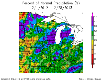
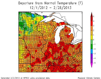
As of March 11, 2013, we have seen twice as much snow with 44.8 inches in the Twin Cities. This is 1.4 inches below normal, so this is pretty close to a typical winter for the metro.  The 2012-2013 meteorological winter (December 1, 2012 to March 1, 2013) for St. Cloud and Twin Cities saw near normal temperatures and precipitation.  It was a different story for the western central and far northern Minnesota as average temperatures were slightly below normal, and precipitation was well above normal.  Some locations saw double the amount of water in a typical meteorological winter.
DepartureFromNormalTemp

PercentOfNormalPrecip

So how do we really feel about winter?  The Minnesota State Climatology Office attempted to quantify the severity of winter by creating an index, known as the Winter Misery Index.

Here is a little information on how it works:

The Winter Misery Index (WMI) is an attempt to weigh the relative severity of winters. The index assigns points for daily counts of maximum temperatures 10 degrees or colder and daily minimums of 0 or colder. If the minimum temperature is -20 or colder greater weight is assigned to the value times 8. For snowfall, one inch is assigned a point per calendar day. A four inch snowfall is times 4, and an 8 inch snowfall is times 8. The duration of a winter is noted by the number of days the snow depth is 12 inches or greater. All current measurements are at the Twin Cities International Airport.

As of March 1, 2013 the WMI in Twin Cities is 53 points, or three points away from the "moderate winter" category.  This roughly parallels snow totals and average temperatures against normal in a given season.  The lowest WMI score was the winter of 2011-2012 with 16 points, a very mild, or comfortable winter. The most severe winter is 1916-1917 with 305 WMI points.

winter_misery_index

The common theme from the information above is that we are going through a normal winter.  We have not one of these in a couple years, so this is more of a reminder of what winter is supposed to be like for the Twin Cities and surrounding area.  With that said, March daytime temperatures are starting off eight degrees below normal.  Temperatures should be running in the upper 30s by now.  Most days in the month so far have been a struggle to hit 30 degrees.  March snowfall averages just over 10 inches, and we are 9.3 inches for the month, so we are near average not even halfway through the month.  It is not so much the winter that people are asking for spring, but rather due to March not starting off the way it should based on averages.  Only time will tell how the rest of the month plays out, and how much of a spring we have this year.

RS

Sunday, March 3, 2013

Late season snows to affect the area beginning tonight

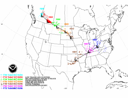
An Alberta clipper system will be the next weather maker across the five-state area heading into tonight, and lasting through Tuesday afternoon.  Two episodes of snow is expected. The first wave will begin tonight lasting through the afternoon hours on Monday. This snow will blanket most of the southern two-thirds of Minnesota. The second wave will primarily effect the Twin Cities area, and locations to the southeast along the Mississippi River on the backside of the low pressure area as it exits the region.

lowtrack_ensembles

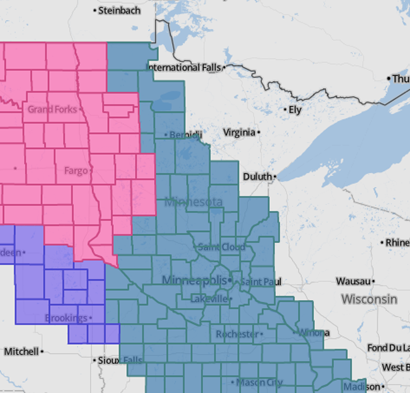
Winter storm watches and winter storm warnings are already in place in anticipation of the snows.  The watch and warnings are in effect through Tuesday.

wwa_03032013

Over the last week, weather forecast models are distinct differences as to the location of the low pressure area, which created uncertain with location and amounts.  The American models painted the bulk of the snow over central and east-central Minnesota, while the non-American models kept the snow to the southwest.  As the snow event approached, the non-American models shifted in agreement with the American models.  Now that we have the general track nailed down, here is a map showing where the heaviest concentration of snows will fall.

snowamts_03032013

March tends to be one of the snowiest months of the year.  Between 1981 and 2010, the Twin Cities averages 10.2 inches of snow for the month.  Here is a look at March snows for locations in southern Minnesota:

Location Avg. monthly snow total (in.)
Minneapolis

10.2

St. Paul

9.9

Rochester

8.7

Redwood Falls 7.9

Mankato

7.8

Faribault

7.3

Worthington

6.7

Albert Lea

6.3

Winona

6.3

Is this the “tournament” snowstorm that is lore in Minnesota weather?

RS