Thursday, January 26, 2012

Winter with a touch of Spring

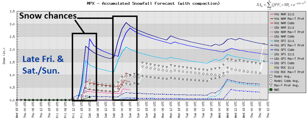
Late Sunday into Monday, we experienced the unfamiliar sight this season of snow. You know, the flakey, white stuff, remember it? While most of the Twin Cities saw one to three inches of snow from this last storm system, it was enough to make for a very slow morning commute on Monday. Freezing mist fell most of Sunday before transitioning to snow late in the day, creating a glazed layer of ice on roadways in addition to snow accumulations to create slippery conditions. At least 100 vehicle spin-outs were reported across the metro. Hopefully you were not one of them! 1.9 inches of snow was recorded officially, bringing our seasonal total up to 14.4 inches. This last snowfall also pushed us beyond the mark for the least amount of seasonal snow of 14.2 inches set in the Dust Bowl era of 1931-32. We should add on to the total as we head into February, and then the second-snowiest month, March. We are not completely out of the clear for January snow. Friday is appearing to be more active, as well as the middle part of the upcoming weekend. It is difficult to pin down exact totals right now, but it does appear to be enough to slow things down a bit for those doing some weekend traveling. Cannot rule out at least an inch or two of snow during each snow episode, but these are not shaping up to be major storms.


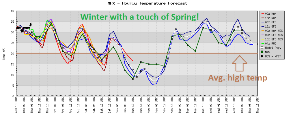
Once we get past the snow, temperatures will noticeably warm up starting Thursday. The first stretch of mild air will last through the weekend. It will be followed by another surge of southerly winds on Tuesday. High temperatures will be running a good 10 to 15 degrees above normal at times during the next seven days. Can someone remind me what season it is again? One thing is for sure, it has made for a very short winter thus far. Hard to believe it's almost February!


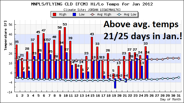
It goes along with the month we are having. Since the beginning of January, we have been above average for high temperatures an incredible 21 out of 25 days! Forget winter, we jumped from fall right into spring! Another sign spring is around the corner? Minnesota Twins pitchers and catchers will be reporting in Fort Myers, Florida for Spring Training on February 18th.

Enjoy "March-uary" or whatever term you would like to call January. Perhaps blogging about the weather has kept the snow away? If that is the case, I could make a lot of good friends that dislike snow very quickly. "Old Man Winter" has certainly been in hibernation this season.

RS

Tuesday, January 24, 2012

Snow totals for January 22 & 23

Here are the snow total reports from the snow late Sunday night into Monday morning.  Generally amounts ranged from one to four inches across the state.  As I highlighted the previous night, I did feel the heaviest snow band would set up along Interstate 35 from the Twin Cities, southward.  Amounts were generally a little higher than I thought they would be.  My thinking was that the severe thunderstorm activity across the mid-south would steal much of the available moisture here for snow.

snow01232012

Snow totals by location (inches of snow, city, county):

Official total highlighted in blue

  • 3.8, MAPLEWOOD, RAMSEY
  • 3.5, OWATONNA, STEELE
  • 3.5, SW ELLENDALE, STEELE
  • 3.5, OAK CENTER, WABASHA
  • 3.4, NORTH ST PAUL, RAMSEY
  • 3.3, ST PAUL, RAMSEY
  • 3.2, ST CLOUD, STEARNS
  • 3.0, ANNANDALE, WRIGHT
  • 3.0, WINTHROP, SIBLEY
  • 3.0, LITCHFIELD, MEEKER
  • 3.0, GLENCOE, MCLEOD
  • 3.0, MANKATO, BLUE EARTH
  • 3.0, 3 SE ALBERT LEA, FREEBORN
  • 3.0, ZUMBROTA, GOODHUE
  • 3.0, MANTORVILLE, DODGE
  • 2.8, HUTCHINSON, MCLEOD
  • 2.8, E OWATONNA, STEELE
  • 2.7, WABASHA 5S, WABASHA
  • 2.6, WINONA , WINONA
  • 2.5, 2 SSW CAMBRIDGE, ISANTI
  • 2.5, MANKATO, BLUE EARTH
  • 2.5, 3 SE NEW ULM, BROWN
  • 2.5, 1 NNW SPRINGFIELD, BROWN
  • 2.4, RICE, BENTON
  • 2.4, NORTHFIELD, RICE
  • 2.3, RUSH CITY, CHISAGO
  • 2.1, MONTICELLO, WRIGHT
  • 2.1, ST CLOUD, STEARNS
  • 2.0, INVER GROVE HEIGHTS, DAKOTA
  • 2.0, 8 NW MORA, KANABEC
  • 2.0, LAKEVILLE, DAKOTA
  • 2.0, HASTINGS, DAKOTA
  • 2.0, 3 SW CARLOS, DOUGLAS
  • 2.0, MADELIA, WATONWAN
  • 2.0, 3 SE LAKE ELMO, WASHINGTON
  • 2.0, ELK RIVER, SHERBURNE
  • 2.0, 3 N KIMBALL, STEARNS
  • 2.0, RED WING, GOODHUE
  • 2.0, 1 NNW COLD SPRING, STEARNS
  • 2.0, PETERSON 1S, FILLMORE
  • 1.9, MINNEAPOLIS, HENNEPIN
  • 1.8, ST PAUL, RAMSEY
  • 1.8, 2 WNW LAKEVILLE, DAKOTA
  • 1.5, LAKEVILLE, DAKOTA
  • 1.5, WINNEBAGO, FARIBAULT
  • 1.5, 1 S BLUE EARTH, FARIBAULT
  • 1.5, 9 NNE BIRD ISLAND, RENVILLE
  • 1.5, FAIRMONT, MARTIN
  • 1.5, 3 SSW MINNEAPOLIS, HENNEPIN
  • 1.3, 1 ENE MINNESOTA LAKE, FARIBAULT
  • 1.3, 1 SW MINNEAPOLIS, HENNEPIN
  • 1.3, MORRIS, STEVENS
  • 1.3, MILACA, MILLE LACS
  • 1.2, WACONIA, CARVER
  • 1.2, NORTH MANKATO, NICOLLET
  • 1.1, ST LOUIS PARK, HENNEPIN
  • 1.1, ONAMIA, MILLE LACS
  • 1.1, RICE, BENTON
  • 1.1, REDWOOD FALLS, REDWOOD
  • 1.0, BROOKLYN CENTER, HENNEPIN
  • 1.0, VESTA MN REDWOOD
  • 1.0, 3 N WATERTOWN, WRIGHT
  • 1.0, 1 ENE ST MICHAEL, WRIGHT
  • 1.0, 3 N CAMBRIDGE, ISANTI
  • 1.0, LITTLE FALLS, MORRISON
  • 0.8, CHANHASSEN, CARVER

The next snow maker is setting up for Monday.  As always, StormChaser Schwartz will be monitoring this develop storm over the upcoming days.

RS

Sunday, January 22, 2012

Transition to snow overnight

Mist and freezing rain has been ongoing throughout the day on Sunday across much of Minnesota.  Across southeastern Minnesota, numerous accidents have been reported as roads are glazed over by a thin layer of ice.  Slowly, this rain is transitioning to snow as we head towards the midnight hour.

radar_01222012_1109pm

Snow bands will rotate around an area of low pressure across southern Minnesota during the morning hours.  While moisture content is meager, it will be enough to support one to two inches of snow across the Interstate 35 corridor from the Twin Cities to the Minnesota/Iowa border.

rucGL_0_qpf_9

The morning commute will be slow with the snow on top of the layer of ice.  Give yourself plenty of time if you have to travel.

RS

Saturday, January 21, 2012

Messy start to Sunday?

Temperatures will trend towards the freezing point by Sunday morning as southerly winds drive warmer air into the area.

closetofreezing

With low pressure systems approaching and temps close to freezing, there is some concern the precipitation to begin the day could be a wintery mix of sleet, or even freezing rain.  A few of the models, such as the SREF, are hinting at sleet, while the GFS and RUC are indicating freezing rain.

SREF:

sleet01212012

RUC:

frzrainSun

The reason for the freezing rain is that we have a warm layer of air in the mid-levels of the atmosphere sandwiched between a cold layer in the upper-levels and at the surface.

skewt012212

For anyone commuting in the morning, you’ll want to use caution. The roads may turn into ice rinks for a brief time during the morning before the change over to all snow in the afternoon.  We’re still looking at about an inch to two inches of snow tomorrow for the Twin Cities with higher amounts across west-central and northwest Minnesota.

RS

Next week storm systems looking quiet for now

Friday’s snow came through during the first half of the day, and dropped generally one to two inches of snow across the Twin Cities. As expected, the heaviest amounts were seen along the Interstate 90 corridor in southern Minnesota, where as much as five inches of snow fell.  The snow ended a bit sooner than I thought, so that kept actuals down from my projections, but were still within the ranges assigned Friday for the most part.  Figuring precise totals will never be an exact science.

snowtotals01202012

Snow totals by location (inches of snow, city, county):

  • 5.0, GRAND MEADOW, MOWER
  • 5.0, JACKSON, JACKSON
  • 5.0, WORTHINGTON, NOBLES
  • 4.6, ALBERT LEA, FREEBORN
  • 4.5, COMFREY, BROWN
  • 4.5, PRESTON, FILLMORE
  • 4.5, LUVERNE, ROCK
  • 4.2, FAIRMONT, MARTIN
  • 4.0, LANESBORO, FILLMORE
  • 4.0, LA CRESCENT DAM, WINONA
  • 4.0, WINDOM, COTTONWOOD
  • 4.0, IVANHOE, LINCOLN
  • 3.8, MADELIA, WATONWAN
  • 3.6, SPRING VALLEY 3E, FILLMORE
  • 3.0, VESTA, REDWOOD
  • 3.0, NEW ULM, BROWN
  • 3.0, MANKATO, BLUE EARTH
  • 3.0, SPRINGFIELD, BROWN
  • 3.0, WINNEBAGO, FARIBAULT
  • 3.0, WSW ST JAMES, WATONWAN
  • 3.0, LAKE CITY, WABASHA
  • 2.9, 1 ENE MINNESOTA LAKE, FARIBAULT
  • 2.8, NE FAIRMONT, MARTIN
  • 2.7, MONTICELLO, WRIGHT
  • 2.0, 1 NNW SPRINGFIELD, BROWN
  • 2.0, MARSHALL, LYON
  • 1.9, 1 ESE MILROY, REDWOOD
  • 1.8, ANDOVER, ANOKA
  • 1.8, THEILMAN, WABASHA
  • 1.7, NORTH MANKATO, NICOLLET
  • 1.7, ELGIN, OLMSTED
  • 1.5, WINTHROP, SIBLEY
  • 1.5, MINNESOTA CITY, WINONA
  • 1.4, ST PAUL, RAMSEY
  • 1.3, PLYMOUTH, HENNEPIN
  • 1.2, MADISON, LAC QUI PARLE
  • 1.1, MINNEAPOLIS, HENNEPIN
  • 1.1, WABASHA, WABASHA
  • 1.0, GLENWOOD, POPE
  • 1.0, ORONO, HENNEPIN
  • 1.0, GOLDEN VALLEY, HENNEPIN
  • 1.0, CHANHASSEN, CARVER
  • 1.0, MENOMONIE, DUNN
  • 1.0, ST LOUIS PARK, HENNEPIN
  • 1.0, NORTH ST PAUL, RAMSEY
  • 1.0, BROOKLYN CENTER, HENNEPIN
  • 1.0, WACONIA, CARVER
  • 1.0, WINONA, WINONA
  • 0.5, ST CLOUD, STEARNS

The forecast models have mellowed out the weather makers for next week in terms of snow, at least for the Twin Cities.  We may see an inch or two on Sunday and then again Wednesday, but no major winter storms are in the foreseeable future before we warm back up to normal towards the end of the month.

Jan2012snowwk4

Sunday’s weather will be impacted by a one, two punch of a couple low pressure areas that will exit the area by Monday.

lowtrack_circlesThe NAM and European models keep the bulk of the snow across west central Minnesota.  Several inches of snow may fall north and west of Alexandria.

wrfGL_0_prec_36

Euro012312

January looks like it will end on a whimper as far as snow goes.  Soon, we will look at the February outlook and see if we end up receiving payback for the quiet winter so far.

RS

Friday, January 20, 2012

Update on Friday snows

We are still on track to see snow, some significant (> 4 inches), across southern sections of Minnesota on Friday as the jet stream overhead ushers in a Pacific system.  This is the same system that brought a snow and ice storm to the Seattle, Washington area on Wednesday and Thursday.  The weather is wrecking havoc on hundreds of thousandths of residents there.  Personally, I’ll take the cold we have here over the mess that has been created in western Washington.

With the cold temperatures, this system will be an efficient snow maker, so just a little bit of perceptible water in the atmosphere will yield higher snow totals.  The Twin Cities will see around two tenths of an inch of perceptible water from this storm.

snowratio

My projections on snow totals changed too much since I last blogged about this storm at the Shakopee Valley News’ (home to perhaps the two hardest working ladies that cover Shakopee like a blanket) The WeatherDesk on Thursday.  We are looking at one to two inches of snow for the northern Twin Cities metro.  South of the Interstate 494/694 loop in the metro, two to three inches of snow is possible.  Outside of the metro, a large area of four to six inches of snow will be possible across south central Minnesota.  The heaviest snow bands will set up along the Interstate 90 corridor, so areas such as Fairmont over to Albert Lea and Austin may see the high end of around six inches.

wrfGL_0_prec_24

Timing wise, we are looking at snow starting before the morning rush on the roadways, so expect slow traffic.  Snow will be ongoing throughout the majority of the day, ending close to midnight.

RUCsnow01202012

Heading into this storm, the Twin Cities has picked up 11.4 inches of snow for the season.  By it’s conclusion, we should have reached a seasonal total of over a foot of snow.  A far cry from the 54.1 inches we had heading into January 20th last year.

RS

Wednesday, January 18, 2012

First subzero temps of the season

The Twin Cities and much of greater Minnesota is in line to experience it’s first subzero temperatures by Thursday morning as Arctic air moves in behind an area of low pressure centered around the Great Lakes.  We normally see the first below zero reading in the Twin Cities on December 9th, so we are running over a month behind on winter.  The latest below zero reading in any given winter season is January 18th.  There has also never been a winter that has not dipped below zero at least twice in the Twin Cities.

My hunch is that we will break this old record Thursday morning (January 19th) as we hover around -5°F for a low in the Twin Cities.  Areas across northwestern Minnesota may see temps drop as low as -25°F, prompting an Extreme Cold Watch for that area.

NAM guidance showing the extend of the polar air across the continental United States mid-day Thursday:

MET_MINF_000

RS

Tuesday, January 17, 2012

First significant snow of the year on Friday?

The first significant snow of the year may arrive on Friday as a Pacific weather system pushes into the area.  The models have fluctuated a bit with intensity and location of this system in the last 24-36 hours, but it will be something to keep a close on.  If this weather maker does come to fruition, then I believe at least four inches of snow will be possible across portions of southern Minnesota.

All models seem to be agreement of a south central location target for snowfall. The GFS favors a broader portion of the target area, while the NAM and Euro models favor the heaviest of the snow across southeastern Minnesota location.  Snow lovers will rejoice in seeing an old friend, Old Man Winter.

GFS:

gfsGL_0_prec_66

NAM:

wrfGL_0_prec_66

Euro:

snow012012

This will be the first of several snow chances looking into next week.  A snow-covered ground looks likely at some point over the next seven days.  Warmer temps are expected through the end of the month, which will work at the snow cover and probably leave us with bare ground by the time February rolls around.

February already?  Time sure flies fast!

RS

Sunday, January 15, 2012

Week in Review: Normal temperatures return

Reality set in last week as high temperatures plummeted from the 30s and 40s to begin the week, to finishing with more seasonal temperatures in the 20s.  The average high this time of the year is 21 degrees.  Welcome to January, this is how it’s supposed to feel!

MSPtempsJan7days

Temperatures will fluctuate quite a bit between now and the end of the month.  Sunday will see highs into the 30s, before trending downward through Wednesday as a cold front moves sweeps across the state early Monday morning.  We may see low temperatures close to zero by the middle of the week.

JanTempsWk3

95fwbgus

A warm-up is on tap to start next week with highs climbing into the 30s by Monday, the 23rd.  January is closing out with above normal temperatures, according to the GFS model, as temperatures hover around the 30 degree mark.

EndJanTemps

While the North Atlantic oscillation (NAO) is forecasted to trend negative during the remainder of January, it will not have a major impact on our weather.  It will force temperatures towards normal in conjunction with La NiƱa. The NAO controls the strength and direction of westerly winds and storm tracks across the North Atlantic and affects weather patterns across the eastern half of the United States. A negative trend means the westerlies are suppressed, and the weather turns colder over the coming weeks.  One of the theories why our winter has been so mild this year is due to the positive NAO from mid-November through January.

While we will see episodes of typical January weather when it comes to temperatures between now and the end of the month, we are not looking at extremes that we saw during the later half of 2010.

RS

Tuesday, January 10, 2012

December weather summary

December continued the ongoing trend of warmer than average temperatures, and lack of winter-like weather conditions. The average temperature in the Twin Cities during the month was 27.8 degrees – finishing 8.1 degrees above normal. According to the National Weather Service in Chanhassen, this was the 13th warmest December in Twin Cities modern history. High temperatures were well above normal during the second half of the month, and saw temperatures soar into the 50s the day after Christmas.  Many lakes are suffering from thin ice, prompting warnings from the Minnesota DNR.

KMSP201112plot-2

Dec2011TempsMSP

Looking at other locations around Minnesota, the St. Cloud temperature pattern was nearly identical to the Twin Cities and finished 9.3 degrees above average for the month at 25.2 degrees.

KSTC201112plot-2

STCDec2011Temps

The trend was much the same across the state with above average everywhere. A good portion of Minnesota was running anywhere from five to ten degrees above normal.

dec11tempdepart

Our mild temperatures brought a couple episodes of rain to the area in December.  Since the ground remained unfrozen, this moisture was able to seep into the moisture-derived soil.  0.99 inch of liquid precipitation fell officially at MSP airport, which was close to normal with a 0.17 inch deficit.  For the year, Minneapolis-St. Paul finished with 26.91 inches of precipitation, which was 3.7 inches below normal.

Dec2011precipMSP

KMSP2011plot

With the late month snowfall and rain across southeastern Minnesota, those areas ended up near normal for December in terms of precipitation.  A large portion of Minnesota saw 25 to 50 percent of normal December precipitation, which did not improve on the drought situation.

dec11precipdep

Stay tuned for more updates on January’s weather!

RS

Saturday, January 7, 2012

Week in review: Record high temperatures on Thursday

A warm front pushed through Minnesota on Thursday, bringing along with it record-breaking temperatures for many locations across the state.

namussfc2012010521

Some parts of southwest Minnesota saw temperature soar into the 60s.  The highest temperature in the state this day was from an automated station near Canby in Yellow Medicine County that recorded 63 degrees.  Around the area, it was 62 degrees at Marshall, and 61 at both Milan and Madison.  According to the Minnesota Climatology Working Group, there has never been a 60 degree temperature recorded during the first week of January in Minnesota's modern climate record.  The warmest it has ever been during this time period in January before Thursday was 59 degrees, occurring on January 7, 2003 in Amboy, MN.  The all-time record high temperature for any day in January is 69 degrees, occurring January 24, 1981 in Montevideo.

The warmth also extended across the Arrowhead of Minnesota.  Duluth, International Falls, and Brainerd all saw record high temperatures.

With a bit of cloud cover, the Twin Cities fell short of breaking the record of 47 degrees set back in 1885, over 125 years ago!  The temperature climbed to 45 degrees.  Since the beginning of January, we have been running well above average for daytime temperatures.  In some cases, over 20 degrees.  We normally should be in the low 20s this time of the year.

MSPJan2012temps

The Twin Cities followed up this historic day for many parts of Minnesota with another day of mild weather.  Just when you thought 45 degrees was warm, the mercury climbed another degree on Friday to 46 degrees.  Bill McAuliffe (@billmcauliffe) of the Star Tribune posted this note on Twitter:

The warmth is not unprecedented.  According to the National Weather Service in Chanhassen on this day (January 7th) in 2003:

Record warmth over Minnesota. Many places reach the 50's including the Twin Cities. St. James hit 59 and the Twin Cities reached 51. Nine golf courses were open in the Twin Cities and 100 golfers were already at the Sundance Golf Course in Maple Grove in the morning.

RS