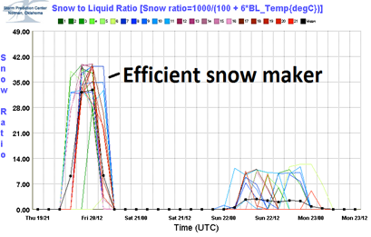
We are still on track to see snow, some significant (> 4 inches), across southern sections of Minnesota on Friday as the jet stream overhead ushers in a Pacific system. This is the same system that brought a snow and ice storm to the Seattle, Washington area on Wednesday and Thursday. The weather is wrecking havoc on hundreds of thousandths of residents there. Personally, I’ll take the cold we have here over the mess that has been created in western Washington.
With the cold temperatures, this system will be an efficient snow maker, so just a little bit of perceptible water in the atmosphere will yield higher snow totals. The Twin Cities will see around two tenths of an inch of perceptible water from this storm.
My projections on snow totals changed too much since I last blogged about this storm at the Shakopee Valley News’ (home to perhaps the two hardest working ladies that cover Shakopee like a blanket) The WeatherDesk on Thursday. We are looking at one to two inches of snow for the northern Twin Cities metro. South of the Interstate 494/694 loop in the metro, two to three inches of snow is possible. Outside of the metro, a large area of four to six inches of snow will be possible across south central Minnesota. The heaviest snow bands will set up along the Interstate 90 corridor, so areas such as Fairmont over to Albert Lea and Austin may see the high end of around six inches.
Timing wise, we are looking at snow starting before the morning rush on the roadways, so expect slow traffic. Snow will be ongoing throughout the majority of the day, ending close to midnight.
Heading into this storm, the Twin Cities has picked up 11.4 inches of snow for the season. By it’s conclusion, we should have reached a seasonal total of over a foot of snow. A far cry from the 54.1 inches we had heading into January 20th last year.
RS


No comments:
Post a Comment