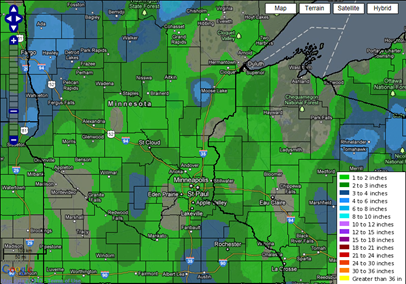
Here are the snow total reports from the snow late Sunday night into Monday morning. Generally amounts ranged from one to four inches across the state. As I highlighted the previous night, I did feel the heaviest snow band would set up along Interstate 35 from the Twin Cities, southward. Amounts were generally a little higher than I thought they would be. My thinking was that the severe thunderstorm activity across the mid-south would steal much of the available moisture here for snow.
Snow totals by location (inches of snow, city, county):
Official total highlighted in blue
- 3.8, MAPLEWOOD, RAMSEY
- 3.5, OWATONNA, STEELE
- 3.5, SW ELLENDALE, STEELE
- 3.5, OAK CENTER, WABASHA
- 3.4, NORTH ST PAUL, RAMSEY
- 3.3, ST PAUL, RAMSEY
- 3.2, ST CLOUD, STEARNS
- 3.0, ANNANDALE, WRIGHT
- 3.0, WINTHROP, SIBLEY
- 3.0, LITCHFIELD, MEEKER
- 3.0, GLENCOE, MCLEOD
- 3.0, MANKATO, BLUE EARTH
- 3.0, 3 SE ALBERT LEA, FREEBORN
- 3.0, ZUMBROTA, GOODHUE
- 3.0, MANTORVILLE, DODGE
- 2.8, HUTCHINSON, MCLEOD
- 2.8, E OWATONNA, STEELE
- 2.7, WABASHA 5S, WABASHA
- 2.6, WINONA , WINONA
- 2.5, 2 SSW CAMBRIDGE, ISANTI
- 2.5, MANKATO, BLUE EARTH
- 2.5, 3 SE NEW ULM, BROWN
- 2.5, 1 NNW SPRINGFIELD, BROWN
- 2.4, RICE, BENTON
- 2.4, NORTHFIELD, RICE
- 2.3, RUSH CITY, CHISAGO
- 2.1, MONTICELLO, WRIGHT
- 2.1, ST CLOUD, STEARNS
- 2.0, INVER GROVE HEIGHTS, DAKOTA
- 2.0, 8 NW MORA, KANABEC
- 2.0, LAKEVILLE, DAKOTA
- 2.0, HASTINGS, DAKOTA
- 2.0, 3 SW CARLOS, DOUGLAS
- 2.0, MADELIA, WATONWAN
- 2.0, 3 SE LAKE ELMO, WASHINGTON
- 2.0, ELK RIVER, SHERBURNE
- 2.0, 3 N KIMBALL, STEARNS
- 2.0, RED WING, GOODHUE
- 2.0, 1 NNW COLD SPRING, STEARNS
- 2.0, PETERSON 1S, FILLMORE
- 1.9, MINNEAPOLIS, HENNEPIN
- 1.8, ST PAUL, RAMSEY
- 1.8, 2 WNW LAKEVILLE, DAKOTA
- 1.5, LAKEVILLE, DAKOTA
- 1.5, WINNEBAGO, FARIBAULT
- 1.5, 1 S BLUE EARTH, FARIBAULT
- 1.5, 9 NNE BIRD ISLAND, RENVILLE
- 1.5, FAIRMONT, MARTIN
- 1.5, 3 SSW MINNEAPOLIS, HENNEPIN
- 1.3, 1 ENE MINNESOTA LAKE, FARIBAULT
- 1.3, 1 SW MINNEAPOLIS, HENNEPIN
- 1.3, MORRIS, STEVENS
- 1.3, MILACA, MILLE LACS
- 1.2, WACONIA, CARVER
- 1.2, NORTH MANKATO, NICOLLET
- 1.1, ST LOUIS PARK, HENNEPIN
- 1.1, ONAMIA, MILLE LACS
- 1.1, RICE, BENTON
- 1.1, REDWOOD FALLS, REDWOOD
- 1.0, BROOKLYN CENTER, HENNEPIN
- 1.0, VESTA MN REDWOOD
- 1.0, 3 N WATERTOWN, WRIGHT
- 1.0, 1 ENE ST MICHAEL, WRIGHT
- 1.0, 3 N CAMBRIDGE, ISANTI
- 1.0, LITTLE FALLS, MORRISON
- 0.8, CHANHASSEN, CARVER
The next snow maker is setting up for Monday. As always, StormChaser Schwartz will be monitoring this develop storm over the upcoming days.
RS


No comments:
Post a Comment