Tuesday, June 28, 2011

Summer is back!

It appears that our 103-degree temperature reading back in early June was not the only glimpse of summer we will see in June.  Temperatures on Thursday should soar into the 90s across Minnesota as the jet lifts into Canada with an upper-level ridge over the Rocky Mountains.  Much of South Dakota will likely hit the century mark for high temperatures, but the question is how far east will the heat spread with the ridge.

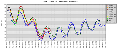
The NAM forecast model is more liberal with the heat and pushes upper 90s into southwest Minnesota:

NAM_221_2011062800_F72_TMPF_2_M_ABOVE_GROUND

The GFS forecast model is a bit more reserved with clouds and precipitation in the area, and keeps the hottest air over South Dakota in the five-state region:

GFS_3_2011062800_F72_TMPF_2_M_ABOVE_GROUND

Based on these two interpretations, I think 100-degree temperatures are out of the question locally.  Most of Minnesota will be in the 90s I believe.  Areas near the Minnesota/South Dakota border will see temperatures in the upper 90s, while from the Twin Cities and points south will be in the low to middle 90s.  In any case, it will feel more like summertime, which has been missing since summer officially began on June 21st.

RS

Saturday, June 25, 2011

Minnesota River levels continue to fall

Over the next week, river levels at locations on the Minnesota River in the Twin Cities metro area are expected to drop as the heaviest of the rains stay south across Iowa through Thursday morning:

p120i12

Along the Minnesota River:

  • Shakopee:  FORECAST...THE RIVER IS FORECAST TO HAVE A MAXIMUM VALUE OF 709.0 FEET THIS AFTERNOON.
  • Savage:  AT 7:00 AM SATURDAY THE STAGE WAS 702.8 FEET.  FORECAST...THE RIVER WILL CONTINUE RISING TO NEAR 703.2 FEET BY MONDAY MORNING THEN BEGIN FALLING.
  • Jordan:  AT 7:15 AM SATURDAY THE STAGE WAS 25.9 FEET.  FORECAST...THE RIVER WILL CONTINUE TO FALL TO BELOW FLOOD STAGE BY THURSDAY EARLY AFTERNOON.
  • Montevideo:  AT 7:00 AM SATURDAY THE STAGE WAS 14.6 FEET. FORECAST...THE RIVER WILL CONTINUE RISING TO NEAR 15.2 FEET BY THIS EVENING THEN BEGIN FALLING.
  • New Ulm:  AT 7:00 AM SATURDAY THE STAGE WAS 797.98 FEET.  FORECAST...THE RIVER IS FORECAST TO HAVE A MAXIMUM VALUE OF 799.1 FEET WEDNESDAY EVENING.

Thankfully, we will not see any road closures out of this.  Between the flooding this spring and last fall, we have seen our fair share of traffic inconveniences due to the flooding!

RS

Wednesday, June 22, 2011

Anoka County tornado summary

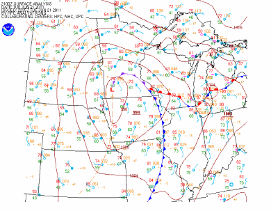
Thunderstorms developed during the afternoon on Tuesday along a low pressure center and associated warm front draped across the area, resulting in storm movement to occur in a counter-clockwise direction from southeast to northwest.  Here is a surface chart as of 4 PM:

11jun21_sfcmap

There was enough shear and vorticity in the atmosphere to make it favorable for low-cloud topped funnel cloud and tornado development.  Around 1:30 PM, the National Weather Service in Chanhassen issued a statement noting the potential for funnel clouds and weak tornadoes during the afternoon hours. By 2:15 PM, the Storm Prediction Center issued a tornado watch for the Twin Cities metro area, southeast Minnesota, and southwest Wisconsin.

261443_221526377869360_194214277267237_810749_6494956_n

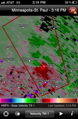
Here is a time lapse of the “action area” that would go on to produce funnel clouds and the eventual tornado in Anoka County.  This velocity radar scan of the red and green areas indicate winds towards and away from the radar, respectively.  Where the green and red areas merge, it forms a tight couplet - indicating rotation within the thunderstorm.

11June21_Zloop

A closer look at the area of interest between Coon Rapids and Blaine from a screen grab I took using the RadarScope app on my iPhone.  Data from 3:16 PM shows the position of the rotating storm that  was verified on the ground by storm spotters as a tornado.  Radar can only detect so much, as it takes a trained eye, such as a SKYWARN spotter, to confirm whether a tornado is actually happening.

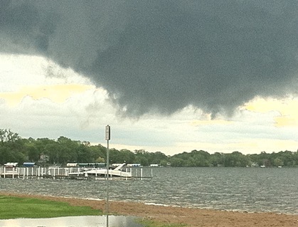
264567_221538914534773_194214277267237_810834_403460_n

The National Weather Service in Chanhassen confirmed on Wednesday that an EF-0 tornado touched down Tuesday in Anoka County, affecting the cities of Blaine and Coon Rapids.

...ANOKA COUNTY TORNADO RATED AN EF-0...

A NATIONAL WEATHER SERVICE STORM DAMAGE SURVEY TEAM ASSESSED THE DAMAGE CAUSED BY THE TUESDAY AFTERNOON THUNDERSTORM THAT TRACKED
NORTHWEST ACROSS SOUTHERN ANOKA COUNTY IN THE TWIN CITIES METRO AREA.

EVENT...EF-0 TORNADO.

LOCATION...FROM NEAR THE INTERSECTION OF U.S. HIGHWAY 10 AND CENTRAL AVENUE IN BLAINE...NORTHWEST TO ABOUT ONE HALF MILE
NORTHWEST OF THE INTERSECTION OF COUNTY HIGHWAY 14 AND HANSON BOULEVARD IN FAR NORTHERN COON RAPIDS.

PATH LENGTH...APPROXIMATELY FIVE AND A HALF MILES.

MAXIMUM WIND SPEED...70 TO 80 MPH.

MAXIMUM WIDTH...75 YARDS.

MOST INTENSE DAMAGE...NEAR A DOZEN LARGE TREES WERE UPROOTED IN AN AREA OF TOWNHOUSES JUST NORTHWEST OF THE U.S. HIGHWAY 10 AND
POLK ST. INTERSECTION IN BLAINE.

TIMING...THIS IS STILL BEING ASSESSED. AT THIS TIME...IT APPEARS THE TORNADO PRIMARILY OCCURRED SOMETIME BETWEEN 310 AND 330 PM.

Weather Service damage path of the tornado using Google mapping:

11June21_TrackMap

Thankfully no injuries or major damage reported with this storm.  Most of the damage seen were trees toppled.  There was one account of a tree that fell on a garage, causing structural damage.

RS

Monday, June 20, 2011

Heavy rain overnight

Heavy rains will come through southern Minnesota and the Twin Cities metro area overnight between 2-4 AM.  The rain may be accompanied by a few rumbles of thunder.

cref_t2sfc_f11

The Twin Cities are looking at anywhere from 1.5 to 2-inches of rain by midday Tuesday with more rain expected into midweek.  The NAM and GFS models seem to indicate around 2.5-inches of rain when it’s all said and done by Thursday.

untitled

Flood watches are warnings are in effect across much of southern Minnesota including the Minnesota River at Jordan and Shakopee in anticipation of the heavy rains expected.

nwswatchwarn

We should get a few peaks of the sun by Friday and dry us out a little bit!

RS

Sunday, June 19, 2011

Early week storms

The big weather newsmaker for early this week will be a storm system slowly tracking from the northeastward from Nebraska. It will be flanked by a warm and cold front as depicted below at 7 PM Monday night.


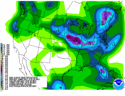
This system will be able to tap into readily available moisture to set the stage for very heavy rainfall rates now through Wednesday night. One of the precipitation forecasts is indicating as much of Minnesota could pick up anywhere from 1.5-inches to over 4-inches of rain during this period. This rain will fall in the Minnesota River and Red River basins, which will increase river levels dramatically over the next week. Minor flooding along area rivers is a possibility should the forecast hold up, which I believe is a strong possibility with a slow moving system. It will take until Thursday until sunshine returns to much of Minnesota.


As far as the severe weather risk goes for Monday, a couple of the models have toned down the parameters for severe weather from Sunday. However, there will still be a risk for strong tornadoes, large hail, and damaging winds across eastern parts of Nebraska into western Iowa. Highlighted below is the area of greatest unstable air mass for thunderstorm development.


As the warm front from Iowa lifts northward, I expect the severe weather threat to decrease, and the existing thunderstorms to become a heavy rain producer into the overnight hours on Tuesday. A threat of severe thunderstorms returns to Minnesota Tuesday afternoon across the southeast part of the state. There will be additional updates as Tuesday’s episode becomes better defined.

RS

Friday, June 17, 2011

Tornado watch for west central Minnesota until 2 AM

New tornado watch just issued by the Storm Prediction Center for most of west central Minnesota until 2 AM Saturday morning.  Watch the skies if you are out this evening!

Included counties:

CHIPPEWA
DOUGLAS
KANDIYOHI
LAC QUI PARLE
MCLEOD
MEEKER
POPE
REDWOOD
RENVILLE
SIBLEY
STEARNS
STEVENS
SWIFT
YELLOW MEDICINE

RS

Strong to severe thunderstorms possible tonight over southern Minnesota

A warm front is expected to begin approaching from the south and with it, will bring a chance of thunderstorms today across the southern half of Minnesota.

2xus_sf

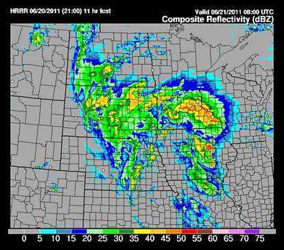
Some of the indications are that these storms could be strong to severe.  Both high resolution models are showing activity developing around Mankato by this evening and move northward ahead of the advancing warm front.  Storm coverage will be isolated and I’m not expecting anything widespread.  Something to keep an eye on if you will be out and about this evening.

today_1h_f24

1ref_sfc_f15

RS

Wednesday, June 8, 2011

More record heat across Minnesota and Wisconsin

This illustration below pretty much sums up the June 7, 2011 heat well!

11June07_highs

Another day of record high temperatures across Minnesota and Wisconsin on Tuesday as the mercury climbed to 100-degrees or greater in many locations, which I thought was a good possibility heading into Tuesday.  According to the National Weather Service in Chanhassen, MSP airport had a high temperature of 103-degrees at 3:26 PM, setting a new record for June 7.  In addition, many other milestones were reached on Tuesday in Minneapolis-St. Paul:

    • Breaks the previous June 7th record of 95° set in 2004.

    • Was the first 100°+ reading since July 31, 2006 (101°).

    • Was the first 103°+ reading in almost 23 years, since July 31, 1988.

    • Was tied for the second warmest temperature in the past 69 years (July 31, 1988 with 105° was the only warmer one)

    • Was the second earliest on record that 103° had occurred, only behind May 31, 1934.

    • Fell 1° short of the all-time June record of 104° set on June 27th, 1934.

According to Dr. Mark Seeley at the Minnesota State Climatology Office, the Minneapolis-St. Paul record temperature was a new all-time statewide record for this date, breaking the previous record of 100-degrees at Madison and Lamberton in 1987.  New high temperature records were also set in St. Cloud, MN at 101-degrees, and Eau Claire, WI at an even 100-degrees.  Locally, close to my home, Flying Cloud Airport in Eden Prairie topped out at 101-degrees.

This is a sharp contrast to the air across northern Minnesota where Duluth only saw a “cool” high of 71-degrees.  Here are some other high temperature readings across northern Minnesota.  if you’re familiar with the geography of northern Minnesota, you can see where the warm front lie during the day.  90-degree temperatures or greater are highlighted in orange, and locations with temperatures lower than 75-degrees are noted in blue.  Pretty sharp contrasts!

DULUTH AIRPORT : 71
INTERNATIONAL FALLS : 69
BRAINERD : 98
GRAND MARAIS MN : 68
HIBBING ARPT : 77
SKY HARBOR : 55
TWO HARBORS : 68
SILVER BAY : 70
GRAND MARAIS : 70
ELY : 79
CRANE LAKE : 72
EVELETH : 79
BIGFORK : 81
GRAND RAPIDS : 81
LONGVILLE : 88
PINE RIVER : 95
AITKIN : 90
MOOSE LAKE : 84
HINCKLEY ARPT : 97
CLOQUET : 70
MCGREGOR : 86

prog00hr

A cold front is forecasted to move through the state into Wisconsin during the overnight hours Wednesday morning, and bring an end to the record heat with it.  Since the atmosphere is capped, we will not see anything in terms of precipitation locally with the heat and cool clash of air masses.  We’ll finish out the week with high temperatures dipping into the mid to upper 60s across a good portion of the state.  A much welcome change for sure.  Comfortable weather for me is 75-degrees and sunny – a sense of balance rather than going from one extreme to the other.  Enjoy a pleasant end to the week!

RS

Tuesday, June 7, 2011

The heat is on!

The big news story lately is the incredible hot air mass over much of the United States as the jet stream has lifted into the southern parts of Canada from the southwest, depicted below.

RUC_255_2011060704_F00_WSPD_250_MB

This allowed the heat “bubble” to travel north and spread through the Midwest, with high temperatures well into the 90s on Monday, and even some sporadic 100-degree temperature readings.

curtemps_600x405

Closer to home, here were some high temperatures from airports across Minnesota and western Wisconsin. MSP airport set a new record for June 6, 2011 with a temperature of 97 degrees. The previous record was 95 degrees set in 1987 and 1979. Areas in southern and southwest Minnesota saw highs climb to 99-degrees! If you wanted to find cooler air around the southern parts of state, you would have to look east into Ladysmith or Rice Lake, Wisconsin, where the mercury was a mere 87 degrees for the day.

hightemps

:                       MAX   MIN 
:ID         LOCATION    TEMP  TEMP
EAU : EAU CLAIRE WI   : 94 /  58 
MSP : MINNEAPOLIS MN  : 97 /  70 
STC : ST CLOUD MN     : 94 /  60 
AXN : ALEXANDRIA MN   : 91 /  61 
MIC : CRYSTAL MN      : 95 /  67 
FCM : FLYING CLOUD MN : 96 /  68 
RWF : REDWOOD FALLS MN: 98 /  66 
STP : ST PAUL MN      : 94 /  65
AEL : ALBERT LEA MN   : 99 /  72
AQP : APPLETON MN     : 95 /  61
BBB : BENSON MN       : 91 /  59
ANE : BLAINE MN       : 91 /  68 
CFE : BUFFALO MN      : 92 /  65 
CBG : CAMBRIDGE MN    : 91 /  66 
CNB : CANBY MN        : 96 /  61 
FRM : FAIRMONT MN     : 99 /  70 
FBL : FARIBAULT MN    : 91 /  70 
GYL : GLENCOE MN      : 96 /  65
GHW : GLENWOOD MN     : 91 /  61 
GDB : GRANITE FALLS MN: 99 /  63 
HCD : HUTCHINSON MN   : 95 /  67 
21D : LAKE ELMO MN    : 91 /  64 
LVN : LAKEVILLE MN    : 93 /  64 
LJF : LITCHFIELD MN   : 91 /  64 
LXL : LITTLE FALLS MN : 90 /  59 
14Y : LONG PRAIRIE    : 90 /  61 
DXX : MADISON MN      : 95 /  61 
MKT : MANKATO MN      : 99 /  72 
MGG : MAPLE LAKE MN   : 92 /  64 
MVE : MONTEVIDEO MN   : 99 /  63 
JMR : MORA MN         : 86 /  55 
MOX : MORRIS MN       : 93 /  61 
ULM : NEW ULM MN      : 97 /  66
OVL : OLIVIA MN       : 95 /  68 
OWA : OWATONNA MN     : 95 /  70 
PEX : PAYNESVILLE MN  : 92 /  61 
PNM : PRINCETON MN    : 91 /  72 
RGK : RED WING MN     : 93 /  66 
ROS : RUSH CITY       : 89 /  58 
D39 : SAUK CENTRE MN  : 93 /  61 
SAZ : STAPLES MN      : 88 /  59 
JYG : ST JAMES MN     : 99 /  70 
SGS : SOUTH ST PAUL MN: 94 /  67 
ACQ : WASECA MN       : 97 /  64
BDH : WILLMAR MN      : 93 /  64 
RPD : RICE LAKE WI    : 87 /  56
LUM : MENOMONIE WI    : 90 /  61 
OEO : OSCEOLA WI      : 91 /  64 
RNH : NEW RICHMOND WI : 90 /  64 
RCX : LADYSMITH WI    : 87 /  58 

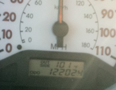
While heating home from work, I had an unofficial temperature reading on my car thermometer of 101-degrees(!) in Eden Prairie just after 6 PM (the official high was 96-degrees at Flying Cloud Airport at 5 PM).  I happened to grab a picture of this rare event:

IMG_0509

The forecast models are indicating that Tuesday will be warmer than Monday’s steamy air mass.  Based on the temperatures we saw Monday, it wouldn't surprise me if we saw many locations across the state around the century mark for highs.  Combine that with the humidity, and we’re looking at a heat index well over 100-degrees!

untitled

heatindex

As a result of this early taste of summer heat, along with the humidity, that National Weather Service in Chanhassen has issued the following warnings and advisories:

Heat Advisory valid at Jun 07, 12:00 PM CDT for Anoka, Carver, Dakota, Freeborn, Goodhue, Le Sueur, Rice, Scott, Steele, Waseca, Washington [MN] and Dunn, Eau Claire, Pepin, Pierce, St. Croix [WI] till Jun 07, 8:00 PM CDT

Excessive Heat Warning valid at Jun 06, 3:00 PM CDT for Hennepin, Ramsey [MN] till Jun 08, 7:00 AM CDT


OVERNIGHT LOWS WILL ONLY FALL IN THE MID 70S... FOLLOWED BY HIGHS IN THE MIDDLE 90S TUESDAY AFTERNOON. HEAT INDEX VALUES ON TUESDAY WILL CLIMB TO AROUND 100 DEGREES.

You'll want to make sure to have plenty of water as it’s very easy to suffer from dehydration on days like this, even if you aren’t moving around much.  Any perspiration is less water in your body.  Also, spending time in an air conditioned space, lake, or swimming pool will also keep you cool.  Elderly folks should be checked on, and ensured that their air conditioning units are working.  By Wednesday, we will see a noticeable drop in temperatures/humidity and a return to more seasonable spring weather.  Until then, stay cool and safe!

RS

Friday, June 3, 2011

May 2011 recap and look ahead towards June

For the month of May, we finished close to normal for temperature and precipitation in the Twin Cities and St. Cloud as well, according to statistics from the National Weather Service - Chanhassen office.  Both locations were nearly one degree below normal for the month.  In the Twin Cities, the big warm-ups on the 10th and 30th of May helped skew the average temperature back towards normal.

Average Temperature

Departure From Normal

Precipitation

Departure From Normal

Minneapolis

58.4°

-0.9°

4.04 in.

+0.80 in.

St. Cloud

55.6°

-0.9°

5.51 in

+2.54 in.

Central Minnesota was slammed with quite a bit of rain during the month and many areas were above normal by about three inches.  All this rain had no where to go but run off into river tributaries, which cause river levels and flood warnings along the rivers to be issued.

Looking back at the May outlook from the Climate Prediction Center, they were pretty much right on the money for how they thought the month would turn out across Minnesota.  With La Nina being phased out and the jet stream primarily over the southern part of the United States, that kept us cool.

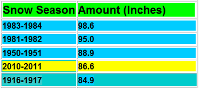
Now for some good news.  The end of May also brought the end of the snowfall for the season.  Yay!  The Twin Cities finished with 86.6 inches of snow, making it the fourth snowiest season on record.  Graphic below from the National Weather Service:

snowrecord

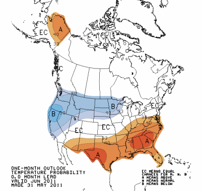
So what does June have in store?  Looks to be the same old story as the past couple months – below normal temperatures and above average precipitation across the state.  The normal temperature in Minneapolis for May is 65 degrees, and precipitation is .26 inches.  I’m hoping these outlooks are wrong for June, but they have been pretty accurate so far in 2011.

off15_temp

off15_prcp

June may also bring about a shift in terms of severe weather.  I think we’ll see an increased number of severe events this summer as the jet stream shifts northward.  La Nina, as well as warmer Gulf of Mexico temperatures, are believed to be the major players for all the tornado outbreaks and havoc on major cities this year.

It should be an interesting month for weather as we begin to see temperatures rise heading into the summer, clashing with cooler air from the north-northwest.  My hunch is that it will be active for stronger storms, and I urge people to monitor the weather and take the tornado watches and warnings issued in particular seriously.  We’re on a record setting pace for tornadoes and there is no sign it’s beginning to slow down.  Stay safe!

RS

Thursday, June 2, 2011

05.21.11 Western Twin Cities MN

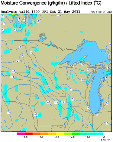
This day was a totally unexpected for storm chasing.  The severe risk of thunderstorms appeared to be across Iowa, and it was cool and cloudy most of the day here.  The sun did finally break out a bit during the afternoon, but it still appeared the best severe weather dynamics were in the far southwestern part of Minnesota with CAPE approaching 2,000 J/kg and the best lifting of air (most unstable air mass) with an index -6 to –8 as of 1 PM Saturday.

cape

LI

By 4 PM, the temperatures had risen into the mid-70s with dewpoints near 60 at MSP.  There was a warm front draped just south of the Twin Cities with moist air surging in behind it.  This boundary was the focal point for storm development.

2011052123_metars_dlh

By 5 PM, strong to severe storms were ongoing just west of the Twin Cities.  Around 5:30 PM, some storms forming near the town of Carver in far eastern Carver County were intensifying rapidly, and it was beginning to catch my interest very quickly.  Since they were just south-southwest of my location, I decided to go after the cell as it raced off to the north through the eastern sections of Carver County into central Hennepin County, around the Lake Minnetonka area.

MPX_N0R_1105212227_800x600_none__0865

I got onto US-169 south from home and took it to Highway 41 in Chaska and drove north to Highway 5 towards Victoria. In Victoria, I took County Road 11 to get me over to Lake Minnetonka near Mound where the road intersects with Highway 7. From Highway 7, I took County Road 44 into Mound to get in position to grab some photos with my cell phone as the storm cell continued to move northward across Lake Minnetonka.

medinaloop

Just after 6 PM, I stopped at Cooks Bay on the west side of Lake Minnetonka.  This bay is familiar to me as it’s one of the public launches that a friend and I use to go fishing.  Here is the radar image from 6:03 PM, showing the most intense part of the cell just to my northeast.

MPX_N0R_1105212303_800x600_none__0865

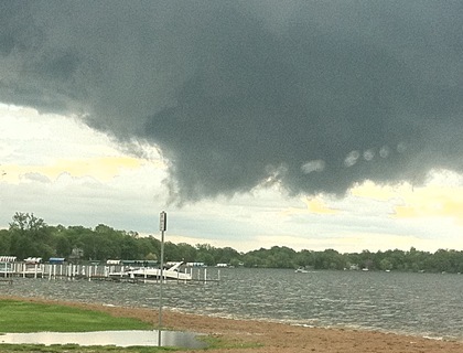
At 6:04 and 6:05 PM respectively, I took these photos of what appeared to be a funnel attempting to form to my northeast over southwestern Orono.  Saw pretty rapid rotation with good inflow.  A definite sign of a mature storm.  I sat in the parking lot for a few minutes to see if this would produce a tornado.
192_thumb2_thumb

194_thumb5_thumb

Here’s a closer look showing my vantage point along with NEXRAD from the same time frame – 6:03 PM.  Circled is the area of interest, which was approximately three miles away from my position.
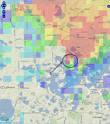
lkmtkaradar

As the storm left my view, I headed north through Mound to attempt to stay on it through the windy roads around Lake Minnetonka.  While in Mound, I came across some large hailstones on the ground at around 6:15 PM as I took a wrong turn and hit a dead end.  At 6:00 PM, a National Weather Service observer reported two inch hail in Mound.  The hailstone in this photo I never measured, but I estimated it to be about two inches in diameter – matching the hail report sent 15 minutes earlier.  I did not report this hail for two reasons.  First, I was in a hurry to get turned around and back on course to position myself for a possible tornado.  Second, hail of the same size was already reported, which would have just duplicated efforts.

196_thumb2_thumb

It was one of the larger hailstones I’ve witnessed ever and thankfully I was not driving underneath this. That’s one reason why I give myself a one or two mile buffer from these storms. I’m not really interested in beating up my car. Also, hail doesn’t interest me as much as cloud formations and tornadoes.  The big pieces are neat to look at, but they’re nothing more than just ice chunks – something you can find in your freezer!

I lost a little bit of time as I was trying to get back on track and headed in the right direction.  I was traveling around the wooded areas of Lake Minnesota, I could see a rather large wall cloud lowered from the cloud base.  It was an amazing site to see.  Unfortunately, I could not find an ideal spot to take a picture of it, and it’s the only part of this chase I regret not having.  I had no idea as to whether a tornado was on the ground, and I could feel my arms shake on the steering wheel as my heart pounded faster not knowing what might be ahead.

This is a photo submitted to KARE11 that was very representative of what I saw as I drove through Orono to get on County Road 15 to eventually get on US-12 East towards I-494.  This was about as much of the wall cloud I saw as I travelled east with the many trees throughout the Lake Minnetonka area.  Only if I had a personal photo of this impressive looking structure!

Photo courtesy of KARE11

Shortly after 6:30 PM, this supercell with the ominous wall cloud moving through the west metro would spawn a brief touchdown according to spotters in the City of Medina at 6:36 PM.  A tornado warning was issued by the National Weather Service in Chanhassen at 6:37 PM:

BULLETIN - EAS ACTIVATION REQUESTED TORNADO WARNING NATIONAL WEATHER SERVICE TWIN CITIES/CHANHASSEN MN 637 PM CDT SAT MAY 21 2011

THE NATIONAL WEATHER SERVICE IN THE TWIN CITIES HAS ISSUED A

* TORNADO WARNING FOR...

SOUTHWESTERN ISANTI COUNTY IN EAST CENTRAL MINNESOTA...

NORTH CENTRAL HENNEPIN COUNTY IN EAST CENTRAL MINNESOTA...

* UNTIL 700 PM CDT

* AT 636 PM CDT...TRAINED WEATHER SPOTTERS REPORTED A TORNADO NEAR NEAR MEDINA... RADAR SHOWED THE TORNADIC STORM MOVING NORTH AT 20 MPH.

Radar image below of when the tornado warning was issued at 6:37PM:

medinatorrefl

As I heard the tornado warning issued, I decided to head towards the Maple Grove area in an attempt to intercept the Medina storm as the supercell began to drift further to the east from it’s original northern track as a result of an outflow boundary attempting to push the activity to the east and help fuel the intensity of the storms.  I took Interstate 494 north from Wayzata and exited the highway on Bass Lake Road in southern Maple Grove.  I initially went west from the off-ramp and waited out the storm from a gas station, but then I decided to find an open area to take photos and away from objects that could be projectiles in high winds like pieces of the awning over the gas pumps.  I found an empty office building parking lot (Upsher-Smith Laboratories) northeast of I-494 and Bass Lake Road, and decided to wait it out there.

The storms moved in about 10 minutes later after arriving around 6:50 PM.  Here is the radar image from 6:49 PM:
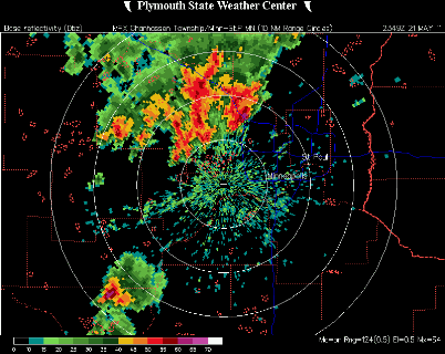
MPX_N0R_1105212349_800x600_none__0865

Here are some pictures I took from Maple Grove between 6:49 PM and 6:54 PM as the storms rolled through:

IMG_0445

An impressive lowering of the cloud base of a wall cloud attempting to develop west-southwest of Interstate 494 and Bass Lake Road:
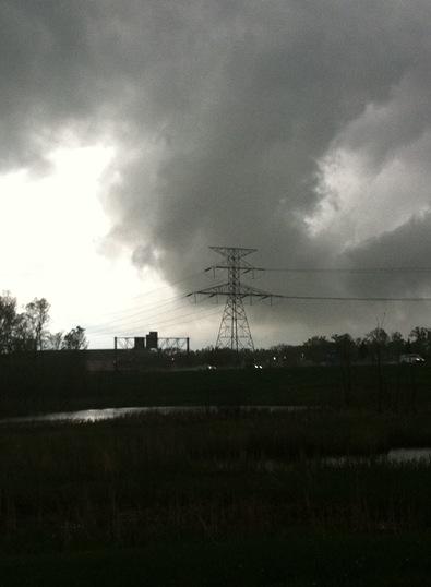
IMG_0449

Tail cloud of this whole cloud feature:

200_thumb2_thumb

A close up of the radar image at 6:49 PM with my position noted relative to the storm.  I was about 4 miles from the little notch that I highlighted with a black circle.

maplegroveradar

As the storms passed to my northwest, I got back on the road and followed the storm in Anoka County along I-694.  I didn’t see anything of interest as the storms sat over the county and decided to call it a day.

This was one of the more interesting chases to date with all the different cloud features and close calls of “catching” a tornado.  Not a bad day considering the notion that I would be chasing this day left my mind at around noon.  In addition, these storms weren’t moving real fast, so it made it a lot easier to get out of the car and take photos without the fear of falling behind the storm.  Very fun chase, and I’m happy to report that there were no major injuries or damage as a result of the storms this day.

RS