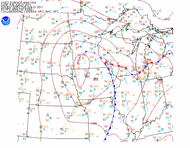
Thunderstorms developed during the afternoon on Tuesday along a low pressure center and associated warm front draped across the area, resulting in storm movement to occur in a counter-clockwise direction from southeast to northwest. Here is a surface chart as of 4 PM:
There was enough shear and vorticity in the atmosphere to make it favorable for low-cloud topped funnel cloud and tornado development. Around 1:30 PM, the National Weather Service in Chanhassen issued a statement noting the potential for funnel clouds and weak tornadoes during the afternoon hours. By 2:15 PM, the Storm Prediction Center issued a tornado watch for the Twin Cities metro area, southeast Minnesota, and southwest Wisconsin.
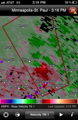
Here is a time lapse of the “action area” that would go on to produce funnel clouds and the eventual tornado in Anoka County. This velocity radar scan of the red and green areas indicate winds towards and away from the radar, respectively. Where the green and red areas merge, it forms a tight couplet - indicating rotation within the thunderstorm.
A closer look at the area of interest between Coon Rapids and Blaine from a screen grab I took using the RadarScope app on my iPhone. Data from 3:16 PM shows the position of the rotating storm that was verified on the ground by storm spotters as a tornado. Radar can only detect so much, as it takes a trained eye, such as a SKYWARN spotter, to confirm whether a tornado is actually happening.
The National Weather Service in Chanhassen confirmed on Wednesday that an EF-0 tornado touched down Tuesday in Anoka County, affecting the cities of Blaine and Coon Rapids.
...ANOKA COUNTY TORNADO RATED AN EF-0...

A NATIONAL WEATHER SERVICE STORM DAMAGE SURVEY TEAM ASSESSED THE DAMAGE CAUSED BY THE TUESDAY AFTERNOON THUNDERSTORM THAT TRACKED
NORTHWEST ACROSS SOUTHERN ANOKA COUNTY IN THE TWIN CITIES METRO AREA.

EVENT...EF-0 TORNADO.

LOCATION...FROM NEAR THE INTERSECTION OF U.S. HIGHWAY 10 AND CENTRAL AVENUE IN BLAINE...NORTHWEST TO ABOUT ONE HALF MILE
NORTHWEST OF THE INTERSECTION OF COUNTY HIGHWAY 14 AND HANSON BOULEVARD IN FAR NORTHERN COON RAPIDS.

PATH LENGTH...APPROXIMATELY FIVE AND A HALF MILES.

MAXIMUM WIND SPEED...70 TO 80 MPH.

MAXIMUM WIDTH...75 YARDS.

MOST INTENSE DAMAGE...NEAR A DOZEN LARGE TREES WERE UPROOTED IN AN AREA OF TOWNHOUSES JUST NORTHWEST OF THE U.S. HIGHWAY 10 AND
POLK ST. INTERSECTION IN BLAINE.

TIMING...THIS IS STILL BEING ASSESSED. AT THIS TIME...IT APPEARS THE TORNADO PRIMARILY OCCURRED SOMETIME BETWEEN 310 AND 330 PM.
Weather Service damage path of the tornado using Google mapping:
Thankfully no injuries or major damage reported with this storm. Most of the damage seen were trees toppled. There was one account of a tree that fell on a garage, causing structural damage.
RS


No comments:
Post a Comment