For the month of May, we finished close to normal for temperature and precipitation in the Twin Cities and St. Cloud as well, according to statistics from the National Weather Service - Chanhassen office. Both locations were nearly one degree below normal for the month. In the Twin Cities, the big warm-ups on the 10th and 30th of May helped skew the average temperature back towards normal.
| Average Temperature | Departure From Normal | Precipitation | Departure From Normal | |
| Minneapolis | 58.4° | -0.9° | 4.04 in. | +0.80 in. |
| St. Cloud | 55.6° | -0.9° | 5.51 in | +2.54 in. |

Central Minnesota was slammed with quite a bit of rain during the month and many areas were above normal by about three inches. All this rain had no where to go but run off into river tributaries, which cause river levels and flood warnings along the rivers to be issued.

Looking back at the May outlook from the Climate Prediction Center, they were pretty much right on the money for how they thought the month would turn out across Minnesota. With La Nina being phased out and the jet stream primarily over the southern part of the United States, that kept us cool.
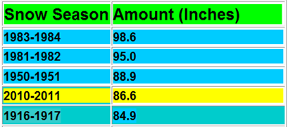
Now for some good news. The end of May also brought the end of the snowfall for the season. Yay! The Twin Cities finished with 86.6 inches of snow, making it the fourth snowiest season on record. Graphic below from the National Weather Service:
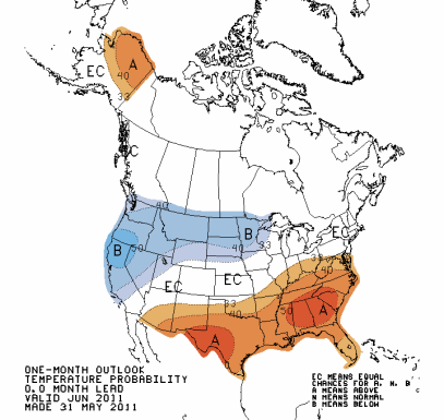
So what does June have in store? Looks to be the same old story as the past couple months – below normal temperatures and above average precipitation across the state. The normal temperature in Minneapolis for May is 65 degrees, and precipitation is .26 inches. I’m hoping these outlooks are wrong for June, but they have been pretty accurate so far in 2011.
June may also bring about a shift in terms of severe weather. I think we’ll see an increased number of severe events this summer as the jet stream shifts northward. La Nina, as well as warmer Gulf of Mexico temperatures, are believed to be the major players for all the tornado outbreaks and havoc on major cities this year.

It should be an interesting month for weather as we begin to see temperatures rise heading into the summer, clashing with cooler air from the north-northwest. My hunch is that it will be active for stronger storms, and I urge people to monitor the weather and take the tornado watches and warnings issued in particular seriously. We’re on a record setting pace for tornadoes and there is no sign it’s beginning to slow down. Stay safe!
RS


No comments:
Post a Comment