Tuesday, August 28, 2012

Summer-like temps to close out August

Hot conditions will be the rule as we close out August as temperatures are expected to climb into the 90s this week, with a shot of 100 degrees by Thursday. I don’t think we’ll see 100 in the Twin Cities, but high temperatures should be in the 95 to 99 degree range Thursday. Typically, Labor Day is the unofficial end to summer, but it will not feel like fall for at least a week.

100s_08302012 

The National Weather Service in the Twin Cities has issued an Excessive Heat Warning for Hennepin and Ramsey Counties for Thursday due to the urban heat island effect.

excessiveheatwarn_08282012

...EXCESSIVE HEAT WATCH IN EFFECT FOR THE TWIN CITIES THURSDAY...

.AN EXCESSIVE HEAT WATCH HAS BEEN ISSUED FOR HENNEPIN AND RAMSEY COUNTIES FOR THIS THURSDAY. WEDNESDAY NIGHT...THE ARRIVAL OF A WARM FRONT WILL BRING WITH IT SOUTHWEST WINDS AND VERY WARM TEMPERATURES INTO THE TWIN CITIES AREA FOR THURSDAY. RECORD HIGHS ARE EXPECTED THURSDAY...WITH ACTUAL AIR TEMPERATURES LIKELY APPROACHING OR EVEN EXCEEDING 100 DEGREES DURING THE AFTERNOON. THOSE PLANNING OUTDOOR ACTIVITIES THURSDAY OR IN STRUCTURES WITHOUT AIR CONDITIONING SHOULD PLAN FOR DANGEROUSLY HOT TEMPERATURES THURSDAY AFTERNOON.


Just when you thought summer was done with, think again.  This might be the last taste of hot weather we’ll see all year, but the way this year has been, we might see 90 degrees in November.  Crazy.


RS

Thursday, August 16, 2012

Storm reports from Wednesday night

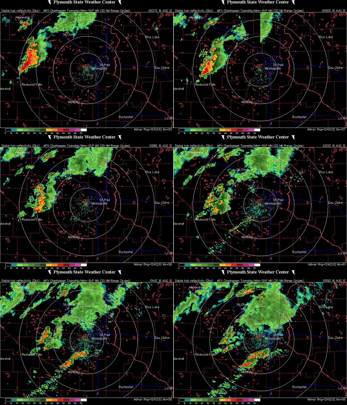
Thunderstorms developed across far western Minnesota during the late afternoon and pushed eastward.  As night came, the air began to stabilize a bit, and the storm complex started to lose signs of life.  During the initial hours, severe weather did occur and large hail fell.

MPX_DHR_1208160159_800x600_none__173_an

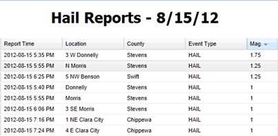
Here is a listing of hail reports meeting severe criteria received by the National Weather Service from Wednesday night.  Golf ball size hail occurred near Donnelly in Stevens County.  Half-dollar size hail was seen near the cities of Morris and Benson.

hailreports_081512

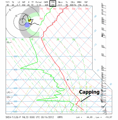
Another reason the storms fell apart as they approached the Twin Cities was that conditions were not favorable for severe thunderstorms.  The 7 pm observations from Chanhassen indicates the atmosphere was capped.  In addition, CAPE values (an indicator of instability) were low, indicating a minimal chance for severe thunderstorms.

mpxob_00z081612

This has been the story all year long. It seems as if one ingredient has always been missing for severe weather, leading to many busts.  It makes me almost believe that “It’s 2012, storms just don’t get real bad here”.

RS

Wednesday, August 15, 2012

A few severe thunderstorms with gusty winds possible today

After a long stretch of quiet weather throughout July and first half of August, the threat for severe thunderstorms returns to the area today as a strong cold front will be moving through Minnesota during the evening hours.

svrthreat_081512

Temperatures are expected to be near 90 degrees across southern Minnesota, with dew points approaching 60 degrees will create just enough instability for convective activity later on today.

eta24hr_sfc_temp_081512

eta24hr_sfc_dewp_081512

Damaging winds are the greatest threat from any of the thunderstorms today as storms are expected to be linear in nature along the cold front pushing eastward.  Winds will have the potential to reach 55 to 60 mph.

The Storm Prediction Center highlights this below:

THE GREATEST SEVERE POTENTIAL HOWEVER -- LIKELY IN THE FORM OF DAMAGING WINDS ASSOCIATED WITH A WELL-ORGANIZED LINE AND POSSIBLY SOME BOWING STRUCTURES -- IS EXPECTED ACROSS A PORTION OF THE ERN DAKOTAS BUT PARTICULARLY MN...FROM FROM MID AFTERNOON THROUGH EARLY EVENING. SOME THREAT MAY CONTINUE EWD INTO WRN PORTIONS OF THE UPPER GREAT LAKES REGION LATER IN THE EVENING...BUT DIURNAL COOLING/STABILIZATION SUGGEST LESSER POTENTIAL THAN EARLIER/FARTHER W.

windthreat_081512

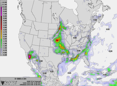
Timing.  Storms are expected to develop during the early evening hours in western Minnesota from near Bemidji to Alexandria.  This is where the greatest concentration of energy for initiation will be located.

NAM_221_2012081506_F18_EHI_3000_M

The line should be into the Twin Cities around 9 to 10 pm, but intensity should diminish once the sun sets and we lose daytime heating, allowing attrition to come into play.  Storms this time of the year are very dependent on heating.  Here is one of the high-resolution models at 9 pm tonight (click the image to enlarge):

4kmWRF_081512_26

I believe the threat for damaging winds will be the greatest west of an International Falls, Grand Rapids, St. Cloud, and Worthington line.  The Twin Cities may see a few strong/severe storms storms depending on when the line begins to lose some of it’s punch.  It will be something to monitor later today.

RS

Wednesday, August 1, 2012

Record July in the books, and a special note to all

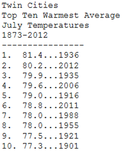
As we finish July 2012, it will go down as one of the warmest months on record.  It is the second warmest July on record in the Twin Cities with an average temperature of 80.2 degrees.

julyrecordtemps

Another distinction during the month was that the high temperature in the Twin Cities never dipped below 80 degrees.  This is the first time in recorded history it has occurred.

july2012tempsprofile

The jet stream has been located across southern Canada, which has allowed very warm air to be pumped in from the south and west for most of the summer.  The placement of the jet stream has brought severe weather, including tornadoes, to Canada, while Minnesota has been tornado-free in July.  It has also been quiet across the United States with only 23 tornadoes reported, according to the National Severe Storms Laboratory in Norman, Oklahoma.

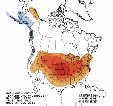
It appears, if the Climate Prediction Center’s forecast for August is correct, that above normal temperatures will continue to be seen across the region.

off15_temp_Aug2012

Will August be just as wacky as July?  Only time will tell.  The severe weather season should begin to wind down as we head into fall.  As a result of the lower probabilities of severe weather expected in August, I have decided to suspend my mobile internet access for the storm chasing laptop.  With this decision, live streaming chase video will not be available for the remainder of the thunderstorm season.  It was a difficult decision, but with a quiet weather pattern, Internet access that goes unused becomes expensive.  This weather hobby is all on my dime, and I do not receive any income from related activities.  I am going to do some reflection during the fall and winter months on a return to storm chasing in 2013.  With changes in my personal life, it becomes tougher to fit chasing into the schedule.  Spending time with those I care about takes a higher priority.  Whatever happens, I have enjoyed the five years going after storms and watching the skies.  It has been a fun ride!

RS