Sunday, October 30, 2011

20th anniversary of the Halloween Blizzard

October 31, 1991 - It was the beginnings of a major snowstorm that significantly impacted Minnesota, Iowa, and Wisconsin as a low pressure system developed near Galveston, Texas and strengthened over the Upper Midwest as it moved northward.  The storm system had ample moisture from the Gulf of Mexico to work with, which resulted in high snow totals.  During this long duration event, snow fell continuously for up to 72 hours, and at a rate of two to three inches per hour at times.  Once the snow finally stopped, it would be one of the most impressive early season winter storms in history across the area.

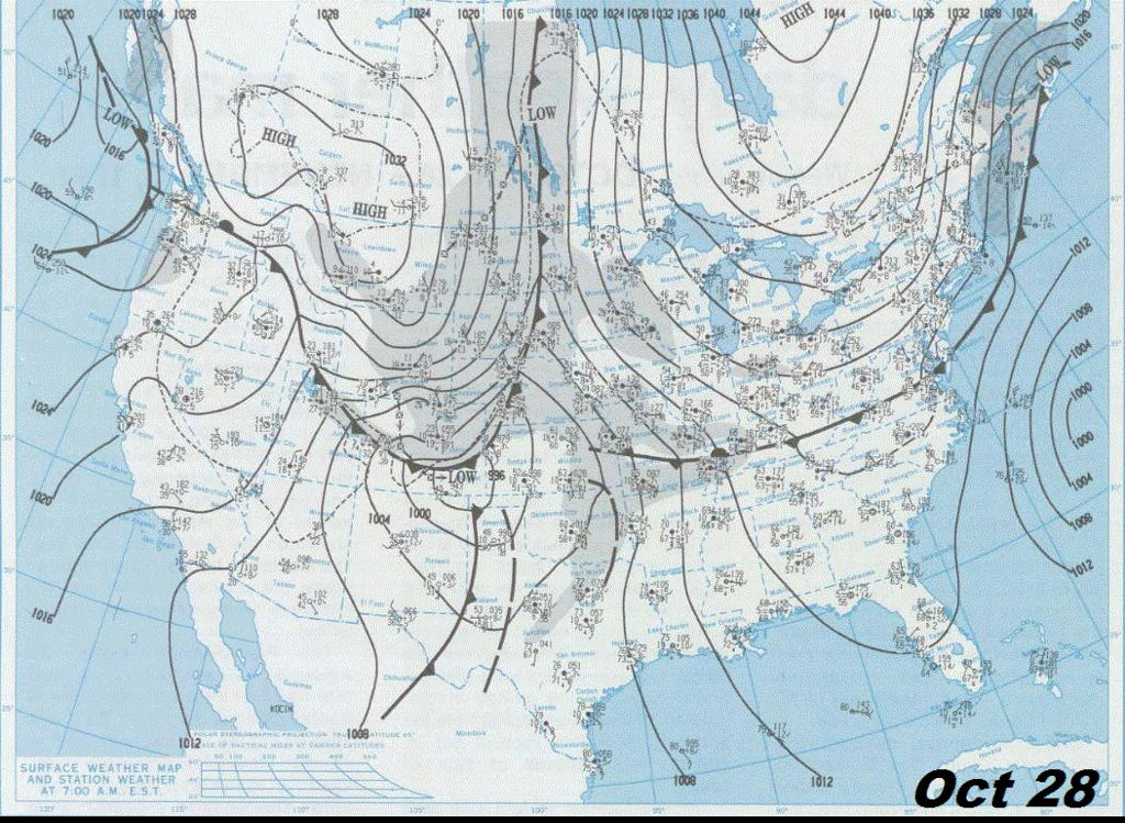
While it was significant for residents of the Upper Midwest, much of the nation’s attention was turned to “The Perfect Storm”, a separate system brewing over the Eastern Seaboard.  This east coast storm would become the subject of a novel written by Sebastian Junger, and later adapted into a Hollywood film.  Having two exceptionally strong storm systems impacting the continental United States at the same time is quite rare.  Depicted below is a plot of the Halloween storm system across the central United States from the National Weather Service in Duluth.

lowtrack

The "Halloween Blizzard" was made possible by a strong Arctic cold front that surged south through the central United States during the final days of October.  The high temperature in the Twin Cities was 65 degrees on October 29th, more than ten degrees above normal.  The next day high temperature in the Twin Cities dropped more than 30 degrees as the mercury reached 32 degrees.  Here is an animated surface map between October 28 and November 3, 1991.  Click for a larger image.

This would be a storm that caught meteorologists and the public off-guard.  Early forecasts from the National Weather Service called for rain across central Minnesota on Halloween.  As Halloween came, the forecast was adjusted for the anticipation of wintery weather with a winter storm watch issued by the National Weather Service in the Twin Cities at 4:00 AM for the potential of a foot of snow.  Snow moved into southern Iowa during the day on October 30th, and then spread into northern Iowa and Minnesota early on October 31st.  Warm air aloft wrapping around the low pressure area caused the snow to change into a mixture of snow, sleet, and freezing rain by mid-morning across portions of southern Minnesota and eastern Iowa.  By 11:30 AM in the Twin Cities, snow began to fall, much earlier than anticipated, and a winter storm warning was issued soon after.  Snow began in Duluth around 1:00 PM.  Kids attempted to trick-or-treat with coats and boots, and pumpkins were covered with a snowy blanket.  8.2 inches of snow fell by midnight on Halloween at the Twin Cities International Airport.  Not only was it a record amount for October 31st, but it was the most snow for the month of October ever in the Twin Cities.

As the calendar transitioned from October to November, the storm system intensified and the low pressure center moved to southeast Iowa by the morning.  During the early morning hours, meteorologist Paul Huttner estimated about 12 to 15 inches of snow on the ground at 3:30 AM in Minnetonka as he left for work at WCCO-TV.  Across the Twin Cities, snow removal became increasing difficult as the snow had started falling on warm pavement, melted, and then formed icy ruts on the roads as the liquid froze.  Roads were described by some motorists as a “washboard”.  The affects were paralyzing.  900 businesses and schools closed throughout Minnesota.  No travel was advised by State Patrol.

A new snowfall record was set for November 1st as 18.5 inches fell at the Twin Cities International Airport, and one to three inches of ice accumulated from southwest Iowa to southeast Minnesota. It would be one of the costliest ice storms in Iowa's history as utility damage totaled $63 million, and 80,000 homes were without power.  Crop damage was estimated around $5 million.  In south central and southeast Minnesota, 11 counties were declared federal disaster areas due to the ice storm.  Damage in Minnesota was $11.7 million.

On November 2nd, the storm became a blizzard when the low pressure center passed over Lake Superior, and created winds up to 50 MPH, with gusts to 60 MPH.  Blizzard warnings were issued as visibilities were limited to near zero across eastern South Dakota, Minnesota, western Iowa, and extreme western Wisconsin.  Blowing snow had been ongoing in Duluth since 2:00 PM on November 1st, and continued for 33 consecutive hours.  The snow ended in southeast Minnesota, southwest Wisconsin, and northeast Iowa by midday.  The Twin Cities picked up 1.1 inches of snow this day.

The heaviest snow ended by November 3rd as the area of low pressure eventually became occluded, and then dissipated as it pushed east into northern Ontario, Canada during subsequent days.  Six tenths of an inch snow fell at the Twin Cities International Airport.  Behind it, colder air filtered in.  The temperature dropped to a low of -3 degrees at the Twin Cities International Airport on November 4th, the earliest below zero reading during the season since records began in 1872.

In the Twin Cities, the Halloween winter storm dropped 28.4 inches of snow, a record single storm total that still stands today.  A record 21 inches of snow fell in a 24-hour period.  Areas along the north shore of Lake Superior received over three feet of snow.  36.9 inches of snow fell on Duluth, a state record for storm total snowfall until 1994.  Many areas from the Arrowhead region through south central Minnesota picked up at least a foot of snow.

1991snow

During the peak of the storm, a 180 mile long stretch of Interstate 90 from the South Dakota border to Rochester, MN had been closed, and stranded motorists took shelter in Albert Lea.  Unfortunately, this storm came with fatalities.  At least 20 people died in Minnesota due to traffic accidents or heart attacks from digging out after the storm. In addition, two Wisconsin hunters died when their boat capsized on Lake Onalaska during the storm.  The Halloween blizzard of 1991 was ranked number three by Minnesota’s climate community for significant Minnesota weather or weather-driven events of the 20th Century.  Only the Dust Bowl of the 1930s and the Armistice Day Blizzard of 1940 were ranked higher.

Additional information on the Midwest Halloween storm:

RS

Saturday, October 15, 2011

Cold enough for snow?

Our stretch run of summer-like fall weather is over as we have returned to more seasonal temperatures across much of Minnesota.

This past Thursday and Friday temperatures were a bit more normal for the Twin Cities.  Friday was also very windy with gusts as high as 39 MPH recorded at MSP.  The October average temperature in the Twin Cities is 52.3 degrees.

KMSP201110normals

Even cooler air will slide into the area early next week as a low pressure system over Hudson Bay in Canada brings a northwest flow of arctic air across the state.  In the upper-levels of the atmosphere, temperatures will be below zero for snow creation.  This may set the stage for the first dusting of snowfall, albeit it won’t last long with the ground still mildly warm, across the northern sections of Minnesota.

coldair

The GFS forecast model indicating precipitation-type to be snow across the arrowhead region of Minnesota Tuesday morning:

firstsnow2011

The GFS is also bit more aggressive with the snow chances and indicates possible accumulating snow towards Ely, MN.  I don’t think it will be the half-inch to an inch as the GFS is indicating with the available moisture not being all that rich.

ElyBUFKIT

The European forecast model backs off a bit on the snow chances and generally indicates more flurries across northwestern Minnesota, as far south as Bemidji, during the first half of the day on Tuesday.  I do tend to favor this solution with snow also possible across the arrowhead.

Eurosnow

This won’t be a “pull out the snowblowers” type of situation, but it’s just another reminder that fall is here, and the snow season is around the corner!

RS

Sunday, October 9, 2011

The streak

The Twin Cities have been on a run of 80-plus degree weather for the last several days.  This has been the longest streak of 80 degree days in the Twin Cities in October since 1953.

Here are the high temperatures throughout the streak.  The 88 degree reading on October 5th set a record for the day, breaking the previous record of 87 degrees set in 1879.  85 degrees on October 7th tied a record for the day.

Date

High temp (°F)

10/2/11 80
10/3/11 83
10/4/11 85
10/5/11 88
10/6/11 83
10/7/11 85
10/8/11 83
10/9/11 83?

I think we’ll see at least one more 80 degree day Sunday as highs top off at around 83 degrees.  If we do reach at least 80 degrees, we will tie the 1953 stretch of consecutive 80-plus degree days with 8.  With clouds moving in for Monday, it appears that the streak will be in jeopardy as temperatures peak into the upper 70s, which by no means is cool for this time of the year.  By next weekend, highs will only reach the 50s in the Twin Cities and 40s outstate - a return to normal temperatures that is projected to last for at least the remainder of the month.

RS

Tuesday, October 4, 2011

Record heat in October? Fire danger increases this week

The very nice stretch continues this week as warm, dry weather is the main weather story across the state.  We will be in the 80s through Friday before temperatures cool down a bit for the weekend and into next week.

We have a shot of breaking a 132-year-old record on Wednesday for high temperatures in the Twin Cities.  The record is 87 degrees, set in 1879.  Both the Twin Cities and southwest suburbs are projected to be around 88 degrees for the day.

KMSP100411

MPX100411

Since the high was 85 degrees for Tuesday, and the models are projecting warmer air for Wednesday, I have no doubts that we should see temperatures approaching 90 degrees for a daytime high. It’s truly an amazing climatological feat considering the lower sun angles this time of the year.

The temperatures combined with the dry spell have set the state for fire conditions across much of southern and western Minnesota through Wednesday as a Red Flag Warning issued for approximately the western third of Minnesota.

rfwalert

So what is a Red Flag Warning?  It’s an alert for dangerous fire conditions and issued by the National Weather Service when these criteria exist:

  1. Sustained one-minute winds at standard 20 foot level are at or above 20 mph. However, in the Red River Valley of northwest Minnesota and in the southwest corner of the state sustained winds must be at or above 25 mph.
  2. Minimum relative humidity at or less than 25 percent.
  3. Temperatures at or greater than 75 degrees F. A “soft temperature threshold” used, mainly in
    spring fire season.

According to Tom Romaine, fire supervisor south for the Minnesota Department of Natural Resources (DNR):

Unusually high temps and low humidity, combined with increasing winds are creating potentially dangerous fire conditions across much of our region.  In the past 24 hours, many counties have put burning restrictions in place and some have banned recreational fires. It is important to for people to check with their county to see what restrictions exist.

Even if restrictions have not been posted in your county, great care should be taken with any outdoor fire right now.

The potential for crop field fires is also high right now. The low moisture content in corn and soybean fields creates a heightened fire danger.  It is more important than ever for farmers to keep machinery clean, make sure guards are in place and carry a fire extinguisher.

Use extra caution with open flames through the end of the week.  Only the slightest chance of rain returns overnight Saturday, but overall the next week looks rain-free.

RS

Sunday, October 2, 2011

September weather summary and October outlook

Much like August, September will go down in the books as one of the driest for the month on record.  In the Twin Cities, just 0.36 inches of rain fell at the Minneapolis-St. Paul International Airport, the least amount of precipitation recorded since observations were taken at the airport.  This 2.72 inches below the normal amount for the month.

YEAR       PRECIPITATION TOTAL (INCHES)
---------------------------------------
2011                      0.36
1940                      0.41
1952                      0.42
2009                      0.46
1969                      0.49

It’s also the second driest September on record for the Twin Cities.  The state was in a “blocking pattern” most of the month as an upper-level low became stationary over northern Illinois, cutting off the necessary moisture needed for rainfall.

For the first time since the middle of May, the Twin Cities is now below normal for annual precipitation:

KMSP2011plot

Locally, across the southwest Twin Cities metro, it has been very dry.  Flying Cloud Airport is about six inches of precipitation below normal.

KFCM2011plot

Across southwest Minnesota, the story is the same.  At Redwood Falls, the area is roughly seven inches of precipitation below normal.

KRWF2011plot

Looking at the bigger picture, a good portion of Minnesota saw 50 percent or less of normal precipitation during the month.  Only extreme northwestern Minnesota saw normal amounts.

m09_11_pperc

As you might have guessed, the lack of rain has aggravated the drought situation further across the state with drought conditions now found across much of southern Minnesota, including the Twin Cities, and severe conditions in the arrowhead region.

mn_dm

As far as temperatures for the month, much of the state saw normal or above normal temperatures for the month.

month_tdev
In the Twin Cities, the average monthly temperature for September was 62.9°F degrees, which was 0.9°F above normal.

KMSP201109plot-2

According to Dr. Mark Seeley, “Extreme temperatures for the month were: 94 degrees F at Madison, Canby, MSP, Redwood Falls, and Winona on September 1st; and just 19 degrees F at Embarrass, Wannaska, and International Falls on the 15th. Minnesota reported the nation's coldest temperature for the 48 contiguous states 4 times during the month: on the 15th, 16th, 17th, and 24th.”

Looking ahead to October, the Climate Prediction Center is forecasting a warmer and wetter month across the state and the eastern half of the country:


off15_temp

Above average precipitation is being indicated across the state, however, the long-term models through the middle of the month are not squeezing out much precipitation during October.


off15_prcp

Will we see snow in October?  At least through mid-October, no.  However, I’ll keep you updated on major weather systems as they approach the area.  Like always, stay tuned!

RS

Thursday’s wind speeds and a new record for the Twin Cities

This past week’s weather was notable for the gusty winds on Thursday.  A strong pressure gradient from west to east across Minnesota, created by a low pressure center sitting out over the Great Lakes, was responsible for the winds.  A well-mixed air mass and unidirectional winds also contributed to the strength.

11Sept29_preschg

Here is a map showing maximum wind speed from around the area:

11Sept29_maxwinds

Text listing of the highest recorded winds from September 29th and some reports from across the Twin Cities metro area:
1.  HANLEY FALLS       1220 PM SEP 29     56 MPH
2.  NEW ULM            1255 PM SEP 29     55 MPH
3.  MANKATO            1155 AM SEP 29     54 MPH
4.  1 SE CLEARWATER     247 PM SEP 29     53 MPH
4T. MINNEAPOLIS ASOS    409 PM SEP 29     53 MPH
4T. MONTEVIDEO         1154 AM SEP 29     53 MPH
4T. EAU CLAIRE ASOS    1227 PM SEP 29     53 MPH

...ANOKA COUNTY...

1 SW BLAINE             445 PM SEP 29     41 MPH
6 WNW FOREST LAKE       406 PM SEP 29     38 MPH
2 NW ANOKA              603 PM SEP 29     33 MPH

...CARVER COUNTY...

3 S CARVER             1149 AM SEP 29     41 MPH
1 ESE WATERTOWN         414 PM SEP 29     41 MPH

...DAKOTA COUNTY...

SOUTH SAINT PAUL       1054 AM SEP 29     51 MPH
3 WSW FARMINGTON       1234 PM SEP 29     48 MPH
2 WSW SOUTH SAINT PAUL 1251 PM SEP 29     45 MPH
1 SSW FARMINGTON       1012 AM SEP 29     37 MPH
2 NE LAKEVILLE          623 PM SEP 29     33 MPH

...HENNEPIN COUNTY...

CRYSTAL ASOS           1153 AM SEP 29     52 MPH
MINNEAPOLIS ASOS        409 PM SEP 29     53 MPH
FLYING CLOUD ASOS       453 PM SEP 29     41 MPH
1 SE MAPLE GROVE        456 PM SEP 29     41 MPH
1 WSW ROBBINSDALE      1102 AM SEP 29     39 MPH
4 ESE RICHFIELD         336 PM SEP 29     37 MPH
1 SW THE LAKE MINNETONK 432 PM SEP 29     36 MPH

...RAMSEY COUNTY...

SAINT PAUL ASOS         353 PM SEP 29     48 MPH
2 NNE SAINT PAUL        356 PM SEP 29     35 MPH

...SCOTT COUNTY...

4 ENE HENDERSON        1246 PM SEP 29     45 MPH
3 W NEW PRAGUE         1137 AM SEP 29     44 MPH
2 WSW PRIOR LAKE       1120 AM SEP 29     41 MPH
1 NW SHAKOPEE           343 PM SEP 29     38 MPH

...WASHINGTON COUNTY...

LAKE SAINT CROIX BEACH 1200 PM SEP 29     44 MPH
2 E LAKE ELMO          1055 AM SEP 29     39 MPH
3 N HASTINGS            516 PM SEP 29     37 MPH
2 N HASTINGS            422 PM SEP 29     37 MPH
Dr. Mark Seeley believes that a new wind record was set in the Twin Cities from a non-thunderstorm for September:
Indeed, 50 mph winds are unusual for the month of September unless they are downburst winds from a thunderstorm. Crystal Airport had a 52 mph wind gust on Thursday (Sept 29) and MSP International Airport reported a wind of 53 mph. The highest September wind gust I can find from MSP is 48 mph back in 2004. So a new non-thunderstorm wind speed record for the month of September was set here in the Twin Cities.
It was quite the amazing phenomenon that we experienced over the past week!

RS