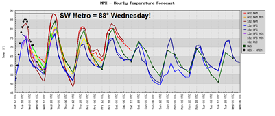
The very nice stretch continues this week as warm, dry weather is the main weather story across the state. We will be in the 80s through Friday before temperatures cool down a bit for the weekend and into next week.
We have a shot of breaking a 132-year-old record on Wednesday for high temperatures in the Twin Cities. The record is 87 degrees, set in 1879. Both the Twin Cities and southwest suburbs are projected to be around 88 degrees for the day.
Since the high was 85 degrees for Tuesday, and the models are projecting warmer air for Wednesday, I have no doubts that we should see temperatures approaching 90 degrees for a daytime high. It’s truly an amazing climatological feat considering the lower sun angles this time of the year.
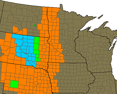
The temperatures combined with the dry spell have set the state for fire conditions across much of southern and western Minnesota through Wednesday as a Red Flag Warning issued for approximately the western third of Minnesota.
So what is a Red Flag Warning? It’s an alert for dangerous fire conditions and issued by the National Weather Service when these criteria exist:
- Sustained one-minute winds at standard 20 foot level are at or above 20 mph. However, in the Red River Valley of northwest Minnesota and in the southwest corner of the state sustained winds must be at or above 25 mph.
- Minimum relative humidity at or less than 25 percent.
- Temperatures at or greater than 75 degrees F. A “soft temperature threshold” used, mainly in
spring fire season.
According to Tom Romaine, fire supervisor south for the Minnesota Department of Natural Resources (DNR):
Unusually high temps and low humidity, combined with increasing winds are creating potentially dangerous fire conditions across much of our region. In the past 24 hours, many counties have put burning restrictions in place and some have banned recreational fires. It is important to for people to check with their county to see what restrictions exist.
Even if restrictions have not been posted in your county, great care should be taken with any outdoor fire right now.
The potential for crop field fires is also high right now. The low moisture content in corn and soybean fields creates a heightened fire danger. It is more important than ever for farmers to keep machinery clean, make sure guards are in place and carry a fire extinguisher.
Use extra caution with open flames through the end of the week. Only the slightest chance of rain returns overnight Saturday, but overall the next week looks rain-free.
RS


No comments:
Post a Comment