Monday, April 30, 2012

Active week ahead with severe weather possible

Warm and humid air from the Gulf of Mexico will move northward to start the work week, bringing with it the possibility of thunderstorms between Tuesday and Thursday.  The best chance for any severe weather will come on Tuesday.

Looking at Tuesday’s weather setup, an area of low pressure, with associated warm and cold front, will move in from the Rockies towards the Fargo vicinity by Tuesday night.

99fwbgus_042912

Behind a warm front and out ahead of a cold front and dry line in the Plains, the central United States will see the greatest risk of severe storms.  The area highlighted below is of most concern.

wrfUS_3km_EHI_48

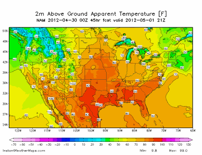
Strong, southern wind flow will cause temperatures to climb into the low 80s across southern and southwestern section of the state by Tuesday afternoon:

USA_APTMPF_2m_045

Dew points are forecasted to be into the 60s across roughly the southern two-thirds of Minnesota:

USA_DPTF_2m_045

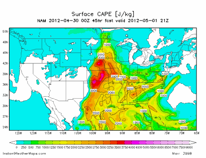
The heat and humidity will create enough energy for thunderstorm development across southwestern Minnesota during the afternoon hours under a moderately unstable atmosphere.  The movement of these storms will be towards the east as the night progresses, pushing into western Wisconsin by the overnight.

USA_CAPE_sfc_045

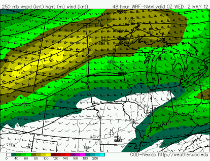
The primary concerns will be large hail and damaging winds.  The jet stream is positioned on the NAM to be north of the greatest area of concern.  If the jet is forecasted to shift further south over the next 24 hours, then a threat for a tornado outbreak would increase.

wrfGL_250_spd_48

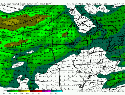
Mid-level winds in excess of 40 knots would support severe thunderstorms:

wrfGL_500_spd_48

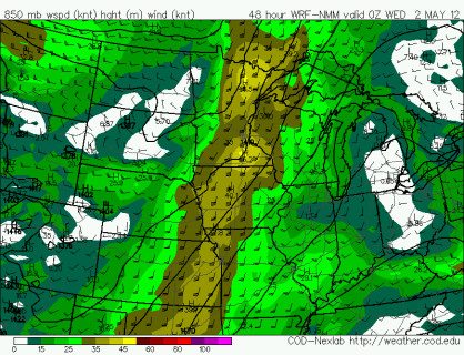
Winds veer from the west towards the south at the surface to support rotating updrafts and perhaps a few tornadoes.  A strong low-level jet Tuesday night will help fuel thunderstorm development.

wrfGL_850_spd_48

Stay tuned on additional details of this potentially active week!

RS

Thursday, April 26, 2012

Late April snow?

At least three of the major overnight models runs going into Thursday were indicating snow chances for Saturday morning.  With Get in Gear festivities going on this Saturday at Minnehaha Park, some have been wondering what the weather conditions will be like at race time.

NAM:

nam_042612

Euro:

Euro_042612

GFS:

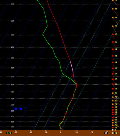
Why snow?  While temperatures will be above freezing at the surface, freezing temperatures will be found aloft, not allowing the snow to melt into rain.

bufkit_042812_1200

I’m expecting any accumulations to be light.  Less than an inch in areas.  For snow lovers, this may be your last hurrah for the snow season.

RS

Wednesday, April 25, 2012

April showers brings May…?

The second half of April, as you have noticed, has been quite wet.  Dry, sunny weekends that we became accustomed to turned rainy and dreary.  This moisture had been much needed however as drought conditions are still considered “severe”, according to the U.S. Drought Monitor, across much of southern Minnesota.  In the Twin Cities, we have picked up 2.69 inches of precipitation this month (no measurable snow recorded).

precip_04252012

Over the last 14 days, much of the state has also picked up precipitation to quench the thirsty lawns and lower the fire danger.  Many locations have seen two to five inches of water.  We have received the necessary relief that on Friday, April 27th, the Minnesota DNR is lifting burning restrictions for 13 counties around the Twin Cities metro and central Minnesota.

precip14days_04252012

Thus far for the year, we are now above average for precipitation with 6.16 inches in the Twin Cities.

KMSP2012plot_042512

What will May have in store?  We will be entering a different climate pattern perhaps as La Niña is expected to be gone by the end of the month.  With hints of a wetter pattern as La Niña slowly fades, will the trend continue into next month?

RS

Monday, April 23, 2012

Minnesota’s cold-core tornadoes

A rather unexpected tornado event occurred Saturday from a cold-core weather system that moved through the state during the day.  Cold-core thunderstorms tend to form with steep lapse rates – a rapid change in temperature with height to create an unstable air mass.  Cold-core funnels are often seen behind cold fronts where there is enough instability and moisture, along with vorticity, to support rotating updrafts in towering, but low-precipitation cumulus clouds.  These funnels may briefly spin up a tornado, but tornadoes in this kind of environment tend to be less violent than your typical twisters found on the Plains.

The Saturday forecast from most, if not all, accounts called for rain, but no mention about the possibility of cold-air funnels or tornadoes.  Since cold-air funnels can occur in clouds not tall enough for thunder, they are difficult to predict and often appear without warning.  The Storm Prediction Center (SPC) forecast for Saturday issued at 11:53 PM (all times noted are CDT) Friday did not outline any portion of Minnesota in a thunderstorm area.

day1otlk_20120421_1200_prt

When the SPC updated their Saturday forecast at 7:21 AM that morning, they included southwest Minnesota in a general thunderstorm category, but no mention of funnels or tornadoes were made in the forecast discussion.

day1otlk_20120421_1300_prt

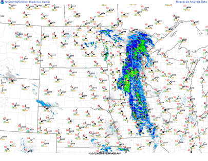
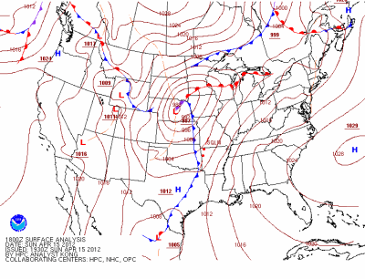
At 1 PM, a low pressure area was centered near Fargo, North Dakota with an associated cold front stretching along the Minnesota/Dakotas border and warm front extending across central Minnesota.  Most of eastern central Minnesota was under a shield of rain, while snow feel across the Arrowhead of Minnesota, ahead of the warm front.

radsfcus_exp2012042118

Storms began to fire right around the noon hour in the vicinity of the the low pressure area.  Temperatures were in the mid-40s across western Minnesota with 60s just across the border into South Dakota where the sun was able to break through during the morning hours.

radar_120421_1700

In the area of convective activity, 500 millibar (18,000 feet) temperatures were running on the order of about -25°C, or -13°F.  That’s some very cold air aloft!

500mb_120421_1700

This temperature difference with the cold pool of air created lapse rates at the low to mid-levels of 7 to 7.5°F for every 1,000 feet across western Minnesota, behind the precipitation band in the eastern part of the state.

lllr_120421_1700

CAPE instability values were running around 250 to 500 J/kg.  Marginal instability for convection.

cape_120421_1900

With these conditions in place, the National Weather Service in Grand Forks issued a Special Weather Statement at 12:44 PM for the Fargo area, indicating conditions were favorable for cold-air funnels and possible brief touchdowns.  The first damage report came in earlier from near Glyndon in Clay County at 12:23 PM.

INCLUDING THE CITIES OF...CROOKSTON...EAST GRAND FORKS...HALSTAD...MOORHEAD...FOSSTON...MAHNOMEN...
DETROIT LAKES... BRECKENRIDGE...FERGUS FALLS

BRIEF COLD AIR FUNNELS ARE POSSIBLE. THE CURRENT ENVIRONMENT IS NOT CONDUCIVE FOR SEVERE THUNDERSTORM BASED TORNADOES. THE FUNNELS MAY BRIEFLY TOUCH DOWN...BUT RARELY CAUSE DAMAGE. CONTACT LOCAL LAW ENFORCEMENT OR THE NATIONAL WEATHER SERVICE IF YOU OBSERVE A FUNNEL.

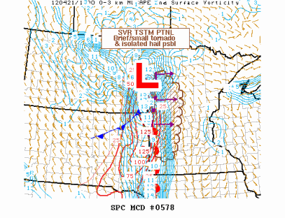
Additional damage reports were coming in south and east of Fargo during the noon and 1 PM hours.  The Grand Forks office decided to forgo issuing tornado warnings during this event.  At 1:55 PM, the Storm Prediction Center highlighted western Minnesota as a favorable area for a “brief/small tornado” through 5 PM, but felt the need for a weather watch box was unlikely in it’s discussion.

mcd0578

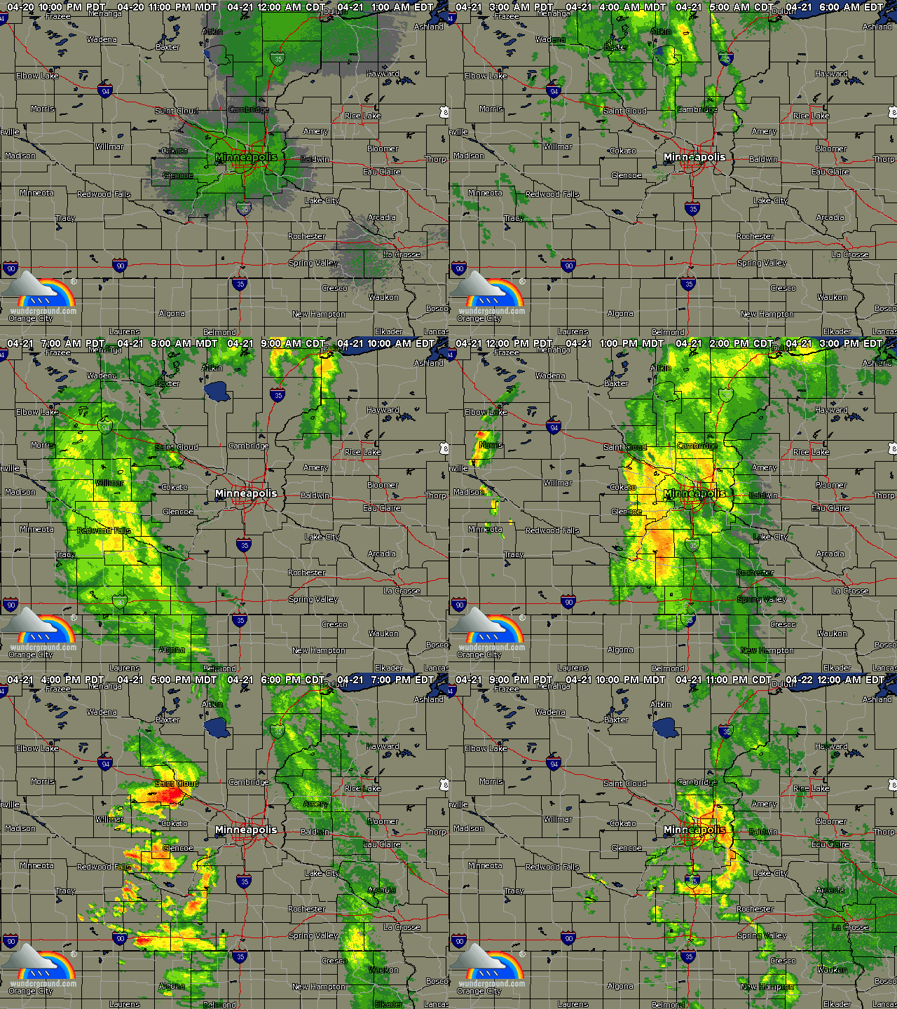
Radar replay of the storms during the afternoon and evening.  As the storms marched east towards the evening hours, they lost their tornadic characteristics moving into a more stable environment.  The last tornado was reported at 3:45 PM in Redwood County.

WUNIDS_composite_archive

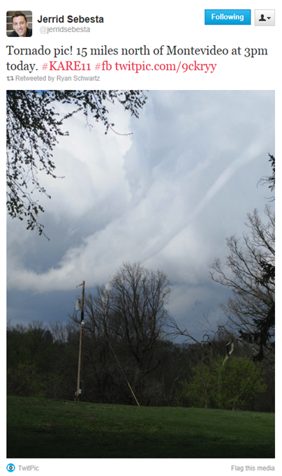
Just after 3 PM, this rope tornado was seen east of Milan and north of Montevideo in Chippewa County.  Photo provided by KARE-11 meteorologist Jerrid Sebesta.

montevideo_coldairtornado

Here is how storm reports stacked up with the SPC’s Saturday morning forecast for the day to measure accuracy.  The weather system was responsible for 10 tornadoes - eight in Minnesota and two in Iowa.  One Iowa tornado was located near the City of Spencer, the largest populated area to be affected this day.

day1otlk_v_20120421_1300

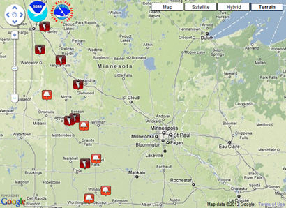
Tornado reports received across Minnesota on Saturday. Adding the eight tornado reports received with the four tornadoes prior to this day, gives us a preliminary count of a dozen for the year.

lsr_04212012

  1. 5 SE Glyndon [Clay Co, MN] trained spotter reports TORNADO at 12:23 PM CDT -- spotter reported 4 foot by 6 foot pieces of tin scattered on both sides of hiway 9. numerous funnels reported in the area with touchdown.
  2. 4 SE Kent [Wilkin Co, MN] law enforcement reports TORNADO at 01:24 PM CDT -- damage to pole barn...trampoline blown on top of garage...and roof damage to trailer. numerous funnels reported in area with touchdown.
  3. 5 S Fergus Falls [Otter Tail Co, MN] law enforcement reports TORNADO at 02:40 PM CDT -- grain bin and shop damaged. numerous funnels reported in the area with brief touchdown. time approximate.
  4. 4 E Milan [Chippewa Co, MN] law enforcement reports TORNADO at 03:11 PM CDT -- barn and grainerys damaged
  5. 6 NNE Walnut Grove [Redwood Co, MN] law enforcement reports TORNADO at 03:23 PM CDT -- multiple reports of funnels with brief touchdowns over 10-15 minutes...time is estimated as is location.
  6. 6 E BIG Bend City [Swift Co, MN] law enforcement reports TORNADO at 03:28 PM CDT
  7. 2 NE Farwell [Douglas Co, MN] law enforcement reports TORNADO at 03:30 PM CDT -- 30-40 foot pole barn taken down...damage to a second barn as well. neighbor witnessed a funnel. time is estimated based on radar.
  8. 7 S Lucan [Redwood Co, MN] law enforcement reports TORNADO at 03:45 PM CDT -- time estimated between 330 and 400 pm cdt. damage to a flower shop.

RS

Friday, April 20, 2012

Minnesota tornado facts

In conclusion of Severe Weather Awareness Week across Minnesota, here are some facts when it comes to tornadoes in the state:

  • Minnesota’s first recorded tornado in history occurred on April 18, 1820 at a camp that eventually became Fort Snelling.
  • There has not been an EF-5 tornado in Minnesota since the Enhanced Fujita scale started February 1, 2007.  The last F-5 tornado in the state was on June 16, 1992, affecting the City of Chandler.
  • Minnesota led the nation in tornadoes with 113 in 2010. 48 of those occurred June 17 as part of largest known outbreak in state history.
  • 31 tornadoes were reported in Minnesota during 2011. Three of those were rated EF-2, the strongest of the year.
  • Since the Enhanced Fujita scale became operational, there have been 229 tornadoes in the state through 2011.   The percentages are as follows: 59% EF-0, 29% EF-1, 7% EF-2, 3% EF-3, 2% EF-4.

RS

Thursday, April 19, 2012

How do you primarily receive weather alerts?

I posed this question on my weather-related Twitter and Facebook accounts to get an idea of how others receive weather alert information.  Here are Twitter responses:

@ckostik: Phone Text message

@RickyMorgan71: Your tweets.

@OSNW3: Nothing automated, I usually know of the situation ahead of time and keep tabs by using the Internet.

@JakeWhiting: I use WeatherBug, Simple Weather Alerts (for Android), and Twitter. One is bound to be on time!

@SwishaJames: NWS website from my phone

@tcollen: ESP :)

@DysonGuy: if on computer weatherbug or interwarn. iPhone / iPad I get text alerts and use WeatherRadio app. Weather radio also

@lars21: Weather Channel app on my phone or NWS site if at home

@GingerFritzie: NOAA Weather Radio for the iPhone.

@MayorTabke: MyWeather on the iPhone

There was one constant I saw: No one said the outdoor sirens!  People are using alternative sources for real-time information.  Thanks to everyone who participated in this unscientific poll.

Weren’t able to chime in with a response?  Feel free to share your methods for receiving alerts in the comment section below.

RS

Wednesday, April 18, 2012

Severe Weather Awareness Week

This week (April 16-20) is Severe Weather Awareness Week in Minnesota.  According to Minnesota Department of Public Safety’s Homeland Security and Emergency Management, “The Severe Weather Awareness Week campaign helps teach Minnesotans about weather hazards and provides resources to minimize the risks associated with severe weather.”  In the past 10 years, more than 40 people have died and dozens more injured as a result of weather-related events in Minnesota (not including motor vehicles).  This blog post will present an overview on what to expect this week as part of Severe Weather Awareness, explain terminology used in weather alerts, and provide alternative methods to traditional media sources for receiving these alerts to stay safe during severe weather.

On Thursday, April 19th, sirens will sound twice as part of a simulated tornado warning.  Once at 1:45 PM, and again at 6:55 PM (all Minnesota counties in the evening except: Aitkin, Becker, Carlton, Hubbard, Itasca, Kanabec, Kittson, Lincoln, Norman, Otter Tail, and Yellow Medicine).  This will provide an opportunity to review action plans at work, school, and home in the event of a natural disaster, such as a tornado.  Sirens will sound for about three minutes.  When the sirens are activated, NOAA Weather Radios will sound an alert tone for a tornado warning.

So what does a watch and warning mean?  A watch means weather conditions are favorable for dangerous weather to occur.  In other words, a "watch" means watch out for what the weather could do, and be ready to act accordingly.  You may wish to alter or have a “Plan B” for any outdoor activities or travel.  A warning means the weather event is imminent or occurring somewhere in the defined warning area and that people need to take shelter as soon as possible.  In 2010, Minnesota had the most tornadoes of any state in the United States with 113.  Tornadoes can occur any time of day or night, but often occur in the late afternoon or evening.  A tornado watch is issued by the National Weather Service when weather conditions are favorable for tornadoes and persons should remain alert for approaching storms.  A tornado warning is issued when a tornado has been sighted or indicated by weather radar.  Take shelter immediately!  Whether a tornado has been radar indicated or confirmed, people should NOT be outdoors looking for the tornado.  There’s a chance it’s already on your doorstep, and by then it’s too late to take cover - leading to injury or possibly death!

How can I stay alert of the latest weather conditions?  I always believe that everyone should have two sources for receiving weather alerts other than outdoor sirens.  An outdoor siren was NOT designed to be heard indoors, and it should NOT be your primary means of warning to take shelter.  Counties and cities own the sirens and therefore decide how and when to activate them, not the National Weather Service.  All sirens are not the same.  There are many different policies by counties and cities.  Some will activate them across the entire county for a tornado warning only.  Others will activate sirens countywide for tornado warnings and all severe thunderstorm warnings.  Some will activate sirens across the entire county for tornado warnings and severe thunderstorms that have winds of at least 70 or 75 MPH, while others will activate sirens only for portions of counties.  Also, local officials may sound the sirens anytime they believe severe weather is a threat, even if there is no warning from the National Weather Service.  In the Twin Cities, Dakota County activates the sirens for any severe thunderstorm warning as well.  A severe thunderstorm warning is issued when thunderstorm winds are indicated or measured to be 58 MPH or greater, and/or contain hail at least one-inch in diameter.  Scott County will typically activate outdoor warning sirens if a tornado warning is issued, according to Chris Weldon, Scott County Emergency Management Director.

Quite frankly, every home should have a NOAA Weather Radio.  They are as essential as smoke detectors in homes.  This is potentially a life-saving device.  The alert technology has been around well before the Internet boom and cell phones, but with enhancements along the way.  Depending on the features, these radios cost anywhere between $20 to $200.  Most brick and mortar retail stores carry these radios (RadioShack tends to have the largest selection), and can also be purchased from online retailers, such as Amazon, using keyword search “weather radio”.  These radios with battery backup are designed to be loud enough to wake you up during a severe weather emergency in the middle of the night, and programmable to broadcast the alert text from the weather service.  Radios with SAME (Specific Alert Message Encoding) technology allow the weather radio to broadcast alerts only for counties you specify using a six-digit code number.  SAME codes can be found here.  It is recommended to select a weather radio with the “Public Alert” certification.  These radio have met certain technical standards and come with many essential features.

There are dozens of radio transmitters covering Minnesota for receiving weather broadcasts.  NOAA weather Radio broadcasts on seven different frequencies, which are pre-configured in most radios as channels.  Nearly every location in the state should receive a good signal.  The one exception is north of Bemidji in Beltrami County near Red Lake.

With the increase in usage of smartphones, apps are becoming more sophisticated.  For iPhone users, iMap Weather Radio is a highly recommended app to alert of approaching hazardous weather for any location using GPS tracking.  When an alert is received, a loud “chirp” tone will sound, and type of alert will be announced.  More details can be found in a review I did here.  According to app maker Weather Decision Technologies, an Android version is currently in development.

Speaking of phones, CellWarn from Convective Development sends weather watches, warnings, and advisories to your email and/or cell phone for free (carrier text message rates may apply).  The free service includes delivery options such as severe thunderstorm watches and warnings, tornado watches and warnings, winter watches, warnings, and advisories, and severe thunderstorm outlooks.

Social media is also a great way to stay informed.  My weather-related Twitter account, @ShakopeeWeather, and Facebook page post warnings for Minnesota as they come in from the National Weather Service.  Other accounts such as @iembot_mpx, posts all Twin Cities National Weather Service products, and @severewarn, posts warnings issued anywhere in the United States.  From my experience, most meteorologists are active on these social media sites during severe weather events, and are prompt with posting weather information pertaining to a dangerous situation.

As we get deeper into the severe weather season across Minnesota, I encourage the general public to start preparing this week for the thunderstorm season by establishing access to alert services and understanding the different weather alerts issued by the National Weather Service.  It will help eliminate any confusion during an actual emergency.  If you would like to get involved as a storm spotter in Minnesota (there are never enough), class schedules are posted here for outstate residents, and here for Twin Cities residents.

Additional information for Severe Weather Awareness Week:

RS

Monday, April 16, 2012

04.15.12 McLeod County, MN

My first real storm chase of the year.  Severe thunderstorms were expected on Sunday, April 15th, as warm, moist air was to surge northward out ahead of a cold front and behind a warm front lifting through south-central Minnesota.

usfntsfc2012041518

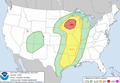
The Storm Prediction Center was confident that a severe weather event would take place that it issued a moderate risk of severe thunderstorms Sunday morning across southeastern Minnesota, as well as portions of Wisconsin, and Iowa.

day1otlk_20120415_1300_prt

Wind shear profile were favorable for the development of tornadoes, some of which could have been strong.

day1probotlk_20120415_1300_torn_prt

From the SPC forecast discussion:

CURRENT THINKING IS THAT THE GREATEST SEVERE CERTAINTY/POTENTIAL CONCENTRATION WILL BE TO THE EAST-NORTHEAST OF THE NORTHEASTWARD ADVANCING SURFACE LOW NEAR WHERE IT INTERSECTS THE WARM FRONT/ADJACENT WARM SECTOR...WITH POSSIBLE OUTFLOW AUGMENTATION AS WELL. ROBUST DEEP LAYER WIND FIELDS...WITH STRONG/ELONGATED LOW LEVEL HODOGRAPHS AND VERY DEEP LAYER SHEAR EASILY ON THE ORDER OF 50+ KT...WILL LIKELY SUPPORT AN INITIAL SEMI-DISCRETE MODE OF FAST NORTHEASTWARD-MOVING SUPERCELLS WITH AN EVOLUTION TO FAST LINE SEGMENTS/BOWS. ACCORDINGLY...ALL SEVERE HAZARDS APPEARS POSSIBLE...INCLUDING THE POSSIBILITY OF TORNADOES...SEVERE HAIL...IN ADDITION TO POSSIBLE SWATHS OF WIND DAMAGE BY LATE AFTERNOON INTO EVENING ACROSS THE UPPER MS VALLEY. TORNADO POTENTIAL /PERHAPS A FEW STRONG/ WILL LIKELY BE HEIGHTENED NEAR/NORTHEAST OF THE SURFACE LOW AND WARM FRONT/PERHAPS RESIDUAL EARLY DAY OUTFLOW.

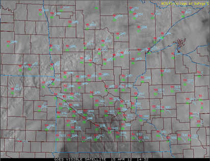
Morning cloudiness really hindered the ability to get a full day of heating to create enough instability for thunderstorms.  This was the concern I had all day, and putting me on the fence as to whether I was going to go out and chase.  Another problem I eventually saw was that winds were out of the south-southeast instead of the south, which prevented the really rich Gulf moisture from getting here.  Dew points at the height of the severe weather were in the low 60s and relative humidity levels in the 60 to 70 percent range outside of the thunderstorms.  Good, but not terribly impressive.

clouds_04152012

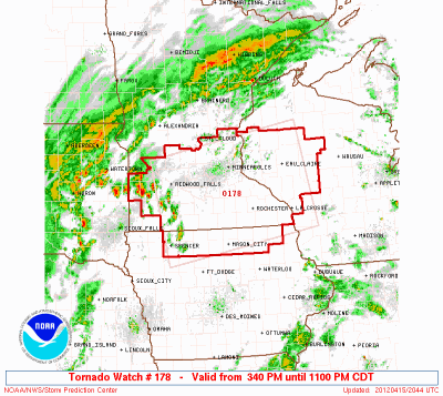
By afternoon, some clearing was able to take place and the sun broke through.  At 3:40 PM, a tornado watch was issued for a good portion of southern Minnesota, with thunderstorm activity expected to develop over southwestern Minnesota and spread east throughout the day.

torwatch178_2012

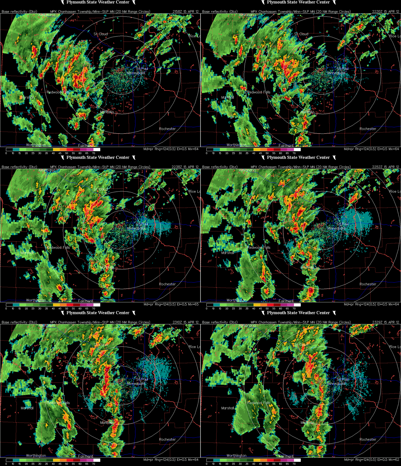
More storms fired during the afternoon and moved north.  Despite thinking this setup didn’t have much promise even with a moderate risk and tornado watch, I decided to head west from Eden Prairie and make a play on storms traveling through McLeod County near Glencoe.

MPX_N0R_1204152329_912x684_KGYL__173_an

As I was heading towards Glencoe on US-212 from the east, I saw this nice cloud formation with an inflow tail on the south side of the highway.  It lasted a couple minutes and then dissipated.  Perhaps it was the most interesting feature I saw on the whole chase.  It may be difficult to see in the video below.  All I had going was a low-res streaming dash cam.

As I passed Glencoe, an interesting hook echo appeared on radar just south of the town of Biscay around 5:20 PM.  I got north on Minnesota State Highway 22 to get on the storm, but found myself about 5 miles out (as the crow flies) from town when a tornado was reported at 5:24 PM, which is when this radar image scan below was taken. Noted is my position as recorded by Spotter Network at 5:24 PM.

Biscaytornado_radar.PNG

AT 524 PM CDT...TRAINED WEATHER SPOTTERS REPORTED A TORNADO. THIS TORNADO WAS LOCATED NEAR BISCAY...OR 7 MILES SOUTHEAST OF HUTCHINSON...MOVING NORTH AT 45 MPH.

I headed north from Biscay on McLeod County Road 4 in hopes of catching a glimpse of the twister to my east over open country, but alas, no dice.

I ran into Minnesota State Highway 7 and headed back east.  On Highway 7, I took Carver County Road 30 into New Germany, and eventually Mayer.  Saw a lot of low topped clouds with rain on this trip, and not a whole lot of lightning.  Between New Germany and Mayer, I ran into a sheet of heavy rain and pea size hail.  The intensity of the storms dwindled as I patronized Carver County, so I decided to call it a day until I bit on some redeveloping storms over Eden Prairie.  I decided to chase those until north of the Interstate 494/US-169 intersection into Edina on US-169 before turning around and finally calling it a day.  By then, the tornado watch box was being dropped from west to east pretty quickly.  Most of the Twin Cities was out of the watch box by 8 PM or so, if I recall correctly.

For an elevated risk of severe thunderstorms this day, there was not a lot of severe weather to be found.  There were just too many things working against severe storm development.  I felt a little letdown, but going in I wasn’t expecting too much this day.  My April chases haven’t been much luck anyway.  This wasn’t the most photogenetic chase, as I didn’t even get out of the car at all to snap photos, which is unusual for me during the daytime.  It would have been nice to see a tornado over open country, in an unpopulated area.  For the Twin Cities sake, I’m glad nothing happened here.

There were just three tornado reports, and a report of one-inch size hail in Glencoe.  A couple funnel clouds reports thrown into the mix as well.  Fortunately, the tornadoes occurred over open land, and no injuries or damage was reported.

lsr_04152012

Using my Spotter Network location tracking log, here is where I traveled on this chase:

Stormchaseplot_04152012 “To infinity and beyond!”

Total severe reports: 0

RS

Sunday, April 15, 2012

Severe weather outbreak for metro and areas southeast today?

A possible severe thunderstorm situation is setting up for the central part of the United States today, including southern Minnesota.  Below is the area I depicted where the greatest threat of severe storms will be found today.

RUC_255_2012041513_F07_EHI3_SURFACE

The Storm Prediction Center in it’s morning outlook placed much of southeastern Minnesota under a moderate risk (an elevated risk if you will) of severe thunderstorms, which includes the Twin Cities, Mankato, and Rochester.

SPCsvroutlook_04152012

Illustrated below is where the greatest tornado threat exists according to the Storm Prediction Center. The purple area is where a greater than 15 percent chance exist for tornadoes.

SPCTORoutlook_04152012

I’m still favor the Wisconsin side of the border for tornadoes today….Menomonie, Eau Claire, and La Crosse.

CONUS_ETA212_ATMOS_STP-NEW_12HR

Bust potential.  The big question with today’s setup is whether we will get out of the clouds and receive the necessary daytime heating for thunderstorm development.  Some clearing is trying to take place across southern Minnesota, near the Iowa border.  If we are in the clouds all day, severe weather will be rather limited.  The tornadoes that have hit Minneapolis over the last several years proves you don’t need an ideal setup for tornadoes to form.

clouds_04152012

Keep an eye to the sky today!

RS

Friday, April 13, 2012

Good chance of severe weather across southern Minnesota this weekend

As an update from my previous post yesterday, the warm front that is one of the drivers for the severe weather outbreak expected this weekend across the U.S. Heartland, will move northward Saturday night and settle over the middle half of Minnesota on Sunday as an area of low pressure navigates towards the area.  This shift will raise temperatures well into the 70s behind the front, and along with it, transport humid, tropical Gulf moisture with dew points into the 60s.

NAM_221_2012041400_F39_TMPF_2_M_ABOVE_GROUND

NAM_221_2012041400_F39_DPTF_2_M_ABOVE_GROUND

Early Sunday morning, the air mass is forecasted to become moderately unstable as CAPE values reach 2000 J/kg.

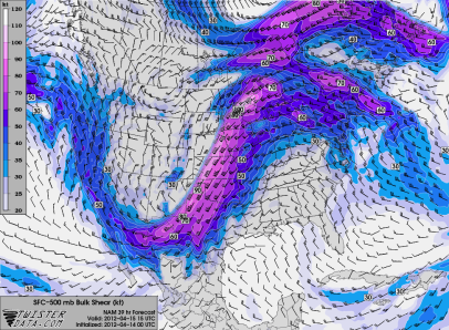
Bulk wind shear values in excess of 60 knots from the surface to 500 millibars will more than support a severe weather event.

NAM_221_2012041400_F39_SHRM_500_MB

With this kind of wind velocity, my worst fears are being confirmed.  There will be an overnight tornado threat going into the day Sunday.  Below is a “tornado index” between 1 a.m. and 1 p.m. Sunday.  Make sure to have your NOAA Weather Radio ready and the alert function turned on.  If you are an iPhone user, now is the time to have iMap Weather Radio installed!

STPanimate

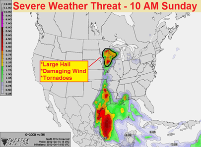
In the Upper Midwest, here is where the greatest threat for severe thunderstorms will be found during the mid-morning on Sunday.  All modes of severe weather will be possible – large hail, damaging winds, and tornadoes.

NAM_221_2012041400_F39_EHI_3000_M

Follow www.stormchaserschwartz.com all weekend long for additional updates!

RS

Thursday, April 12, 2012

Severe potential this weekend

A potentially explosive severe weather situation is setting up over the Central Plains this weekend as a low pressure area, with associated warm front and dry line, set up east of the Rockies on Saturday.

sfcmap_04152012_00z

A moist, unstable air mass is forecasted behind the warm front and out ahead of the dry line.

Strong south winds at the surface turning more westerly with height will help create enough shear in the atmosphere for rotating supercells.  These supercells will be capable of producing tornadoes, perhaps large and destructive ones.  In addition, large hail and damaging winds can be expected.

Winds at 850 millibars (~5,000 feet):

NAM_221_2012041300_F42_WSPD_850_MB

Winds at 500 millibars (~18,000 feet):

NAM_221_2012041300_F42_WSPD_500_MB

The area where I see the greatest threat for severe thunderstorms, including tornadoes, is over eastern Nebraska and western Iowa.  If I wasn’t going to a Twins game Saturday at Target Field, I would consider the Sioux City, Iowa area as an initial chase target.

NAM_221_2012041218_F48_EHI_3000_M

As for Minnesota, it will all depend on where the warm front lines up.  If the models move it further north over the next day, then the chance for severe thunderstorms increases in the area.  Right now, the bulk of the heaviest weather should stay south of the Interstate 90 corridor.  Any strong storms that develop north of the warm front in an elevated environment will be capable of hail and gusty winds.

RS