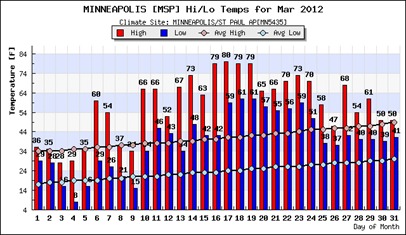
This week we said goodbye to March and hello to April. March 2012 was one of the warmest relative months I have ever experienced here in Minnesota. I could not remember the last time there was a stretch of 70 degree temperatures in March. We hit 80 on the 17th, which was the earliest date to record such a mark during the year.
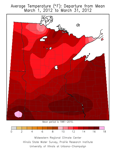
It was a whopping 15.5 degrees above normal at MSP Airport, and warmest March on record. Pretty much the same story across the state with temps at least 10 degrees above normal everywhere.
The trend over the last 115 years indicates that the our Marches have indeed become warmer in Minnesota. Since 1895, the average temperature has increased nearly three degrees, or an increase of around a quarter-degree per decade. Is this cyclical or climate change? Honestly, I don’t know.
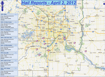
The warmth also brought strong storms to the area Monday as a low level jet interacted with a trough of low pressure. Hail was the primary concern with these storms into the night as they tracked across the southern Twin Cities metro.
I decided to venture out as the western most storm cell headed into Scott County and the Shakopee area.
All I saw out of this was some pea size hail, lightning, and much needed rainfall.
Most of the hail reports where below severe levels of one-inch, but one report from Burnsville indicated one-inch hail.
A more potent storm system took aim across the southern United States on Tuesday with a chance of severe thunderstorms, including tornadoes.
Shortly after noon central time, a tornado watch was issued for the Dallas-Fort Worth (DFW) metroplex.
Between noon and 3 PM, DFW was under the gun for tornadic activity.
Radar summary of the supercells producing the tornadoes from that afternoon.
One of the most awe-inspiring images and video from this tornado outbreak was watching semi-truck trailers, upwards of 15,000 pounds (7.5 tons!), being tossed into the air like toys.
New data is still coming in, but the National Weather Service in Dallas/Fort Worth has determined that at least 15 tornadoes occurred in the metro area and areas to the east. While there were injuries, miraculously no deaths were reported. Most of the tornadoes were of EF-0 strength, which affected populated areas such as Dallas and Arlington, Texas. The strongest tornado was an EF-3 in Forney, Texas.

What is helping fuel these thunderstorms across the south is the warm Gulf of Mexico water temperatures, which are in the upper 70s and low 80s. With the mild winter, the Gulf of Mexico really did not have a chance to cool down. Under these conditions, moisture is very easily transported into the atmosphere.
Looking ahead to the remainder of April, much of the United States is expected to see above normal temperatures according to the Climate Prediction Center.
Temperatures in the Twin Cities are already running above average for the month. Back on April 2nd, we saw a low temperature that we typically see for a high temperature on that day!
As far as precipitation, we should be dry generally until the middle of the month. For the last several days, the GFS model has been hinting at significant rains around the 14th to 16th time frame. After this system moves through, new model guidance suggest that we will be in blocking pattern into the fourth week of April, keeping us dry.
In the short term, this weekend will be very nice. Some showers are possible around mid-day Saturday (as much as a tenth of an inch of rain), but Easter is looking mild and dry. Couldn’t ask for better weather on this holiday.
Happy Easter! Hope it’s a good one for you and your family.
RS


No comments:
Post a Comment