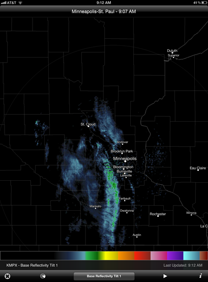
Today we will see the chances for showers all day. Speaking of which, when was the last time a Saturday or Sunday has been wet during the daytime?
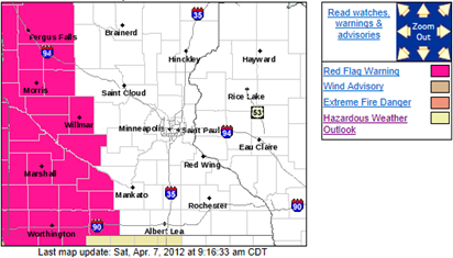
A fire danger threat exist all weekend as relative humidity levels drop to the 25 percent or lower range to trigger a Red Flag Warning. A Red Flag Warning is effect for western Minnesota today.
...RED FLAG WARNING IN EFFECT FROM 2 PM THIS AFTERNOON TO 8 PM CDT THIS EVENING FOR WIND AND LOW RELATIVE HUMIDITY FOR WEST CENTRAL INTO SOUTH CENTRAL MINNESOTA...
THE NATIONAL WEATHER SERVICE IN TWIN CITIES/CHANHASSEN HAS ISSUED A RED FLAG WARNING FOR WIND AND LOW RELATIVE HUMIDITY...WHICH IS IN EFFECT FROM 2 PM THIS AFTERNOON TO 8 PM CDT THIS EVENING. THE FIRE WEATHER WATCH IS NO LONGER IN EFFECT.
* WINDS...BY NOON WEST 20 TO 25 MPH WITH GUSTS AROUND 35 MPH.
* RELATIVE HUMIDITY...25 PERCENT OR LOWER THIS AFTERNOON.
* IMPACTS...THE COMBINATION OF LOW RELATIVE HUMIDITY...STRONG WINDS AND DRY FUELS WILL CREATE DANGEROUS FIRE WEATHER CONDITIONS THIS AFTERNOON INTO EARLY EVENING WHICH COULD CAUSE FIRES TO GROW QUICKLY.
PRECAUTIONARY/PREPAREDNESS ACTIONS...
A RED FLAG WARNING MEANS THAT CRITICAL FIRE WEATHER CONDITIONS ARE EITHER OCCURRING NOW...OR WILL SHORTLY. A COMBINATION OF STRONG WINDS...LOW RELATIVE HUMIDITY...AND DRY FUELS WILL CREATE EXPLOSIVE FIRE GROWTH POTENTIAL.
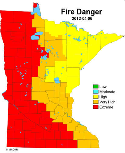
Meanwhile, the Minnesota Department of Natural Resources indicates fire danger to be between high and extreme across the state. Much of western and southwestern Minnesota falls under the extreme category.
According to the DNR, extreme fire danger is:
The fire situation is explosive and can result in extensive property damage. Fires under extreme conditions start quickly, spread furiously, and burn intensely. All fires are potentially serious. Development into high-intensity burning will usually be faster and occur from smaller fires than in the very high danger class. Direct attack is rarely possible, and may be dangerous, except immediately after ignition. Fires burning in heavy slash or in conifer stands may be unmanageable while the extreme burning condition lasts. Under these conditions, the only effective and safe control action is on the flanks until the weather changes or the fuel supply lessens.
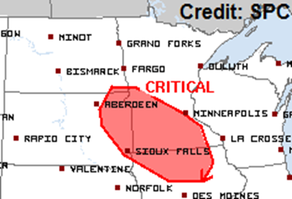
The Storm Prediction Center produces a fire weather outlook. They have issued a critical risk of fire danger for a good portion of southern Minnesota on Easter Sunday as relative humidity values are forecasted to be in the 15 to 20 percent range, and sustained winds of 20 MPH. We will likely see more Red Flag Warnings again tomorrow.
Be extra careful with your fires this weekend, or better yet, avoid any type of fire altogether. Under these conditions, an uncontrolled fire can spread pretty quickly and it will be too late.
RS


No comments:
Post a Comment