A rather unexpected tornado event occurred Saturday from a cold-core weather system that moved through the state during the day. Cold-core thunderstorms tend to form with steep lapse rates – a rapid change in temperature with height to create an unstable air mass. Cold-core funnels are often seen behind cold fronts where there is enough instability and moisture, along with vorticity, to support rotating updrafts in towering, but low-precipitation cumulus clouds. These funnels may briefly spin up a tornado, but tornadoes in this kind of environment tend to be less violent than your typical twisters found on the Plains.
The Saturday forecast from most, if not all, accounts called for rain, but no mention about the possibility of cold-air funnels or tornadoes. Since cold-air funnels can occur in clouds not tall enough for thunder, they are difficult to predict and often appear without warning. The Storm Prediction Center (SPC) forecast for Saturday issued at 11:53 PM (all times noted are CDT) Friday did not outline any portion of Minnesota in a thunderstorm area.
When the SPC updated their Saturday forecast at 7:21 AM that morning, they included southwest Minnesota in a general thunderstorm category, but no mention of funnels or tornadoes were made in the forecast discussion.
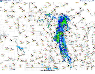
At 1 PM, a low pressure area was centered near Fargo, North Dakota with an associated cold front stretching along the Minnesota/Dakotas border and warm front extending across central Minnesota. Most of eastern central Minnesota was under a shield of rain, while snow feel across the Arrowhead of Minnesota, ahead of the warm front.
Storms began to fire right around the noon hour in the vicinity of the the low pressure area. Temperatures were in the mid-40s across western Minnesota with 60s just across the border into South Dakota where the sun was able to break through during the morning hours.
In the area of convective activity, 500 millibar (18,000 feet) temperatures were running on the order of about -25°C, or -13°F. That’s some very cold air aloft!
This temperature difference with the cold pool of air created lapse rates at the low to mid-levels of 7 to 7.5°F for every 1,000 feet across western Minnesota, behind the precipitation band in the eastern part of the state.
CAPE instability values were running around 250 to 500 J/kg. Marginal instability for convection.
With these conditions in place, the National Weather Service in Grand Forks issued a Special Weather Statement at 12:44 PM for the Fargo area, indicating conditions were favorable for cold-air funnels and possible brief touchdowns. The first damage report came in earlier from near Glyndon in Clay County at 12:23 PM.
INCLUDING THE CITIES OF...CROOKSTON...EAST GRAND FORKS...HALSTAD...MOORHEAD...FOSSTON...MAHNOMEN...
DETROIT LAKES... BRECKENRIDGE...FERGUS FALLSBRIEF COLD AIR FUNNELS ARE POSSIBLE. THE CURRENT ENVIRONMENT IS NOT CONDUCIVE FOR SEVERE THUNDERSTORM BASED TORNADOES. THE FUNNELS MAY BRIEFLY TOUCH DOWN...BUT RARELY CAUSE DAMAGE. CONTACT LOCAL LAW ENFORCEMENT OR THE NATIONAL WEATHER SERVICE IF YOU OBSERVE A FUNNEL.
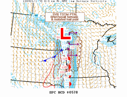
Additional damage reports were coming in south and east of Fargo during the noon and 1 PM hours. The Grand Forks office decided to forgo issuing tornado warnings during this event. At 1:55 PM, the Storm Prediction Center highlighted western Minnesota as a favorable area for a “brief/small tornado” through 5 PM, but felt the need for a weather watch box was unlikely in it’s discussion.
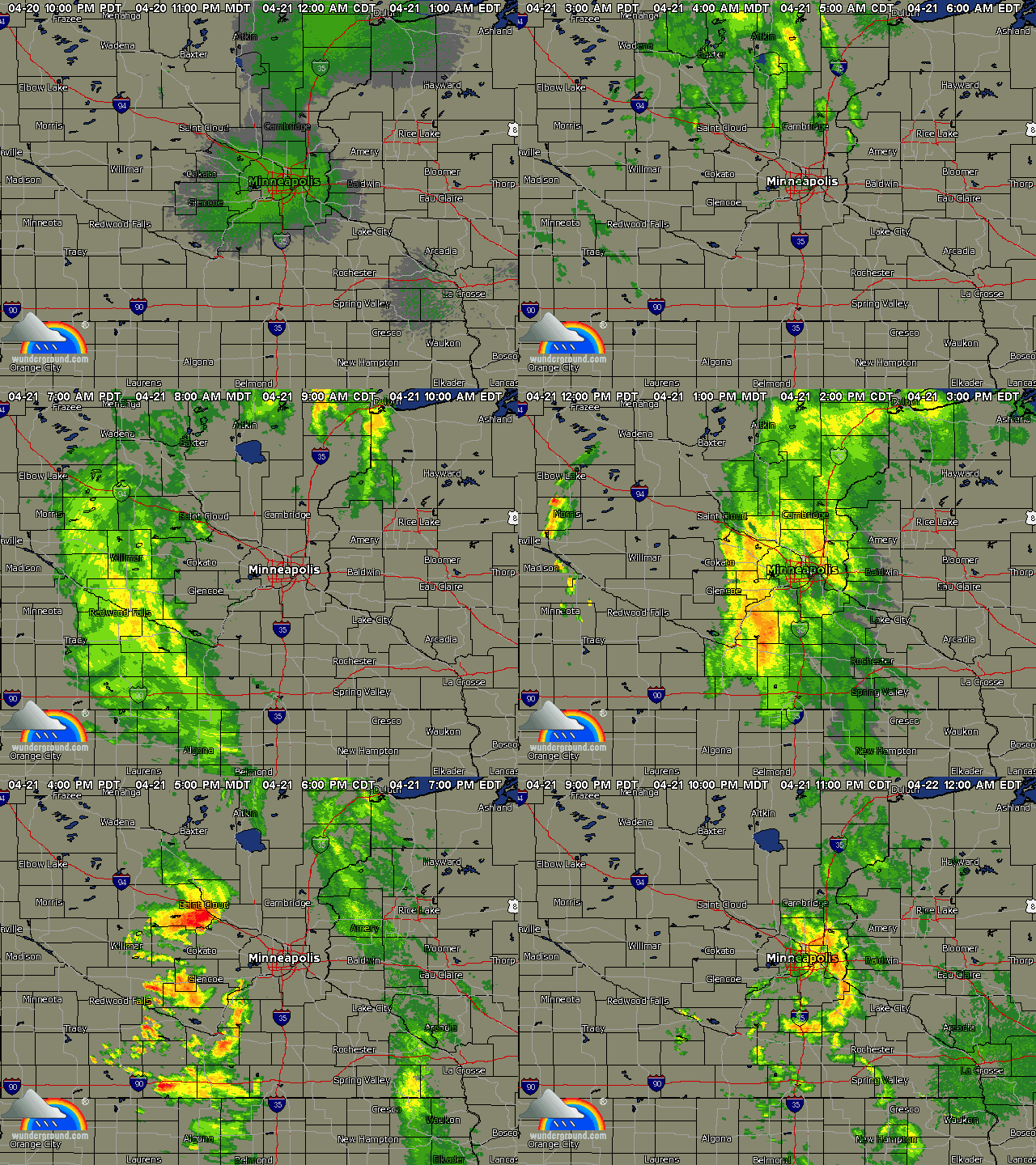
Radar replay of the storms during the afternoon and evening. As the storms marched east towards the evening hours, they lost their tornadic characteristics moving into a more stable environment. The last tornado was reported at 3:45 PM in Redwood County.
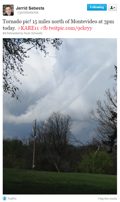
Just after 3 PM, this rope tornado was seen east of Milan and north of Montevideo in Chippewa County. Photo provided by KARE-11 meteorologist Jerrid Sebesta.
Here is how storm reports stacked up with the SPC’s Saturday morning forecast for the day to measure accuracy. The weather system was responsible for 10 tornadoes - eight in Minnesota and two in Iowa. One Iowa tornado was located near the City of Spencer, the largest populated area to be affected this day.
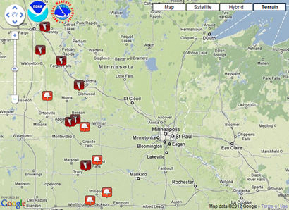
Tornado reports received across Minnesota on Saturday. Adding the eight tornado reports received with the four tornadoes prior to this day, gives us a preliminary count of a dozen for the year.
- 5 SE Glyndon [Clay Co, MN] trained spotter reports TORNADO at 12:23 PM CDT -- spotter reported 4 foot by 6 foot pieces of tin scattered on both sides of hiway 9. numerous funnels reported in the area with touchdown.
- 4 SE Kent [Wilkin Co, MN] law enforcement reports TORNADO at 01:24 PM CDT -- damage to pole barn...trampoline blown on top of garage...and roof damage to trailer. numerous funnels reported in area with touchdown.
- 5 S Fergus Falls [Otter Tail Co, MN] law enforcement reports TORNADO at 02:40 PM CDT -- grain bin and shop damaged. numerous funnels reported in the area with brief touchdown. time approximate.
- 4 E Milan [Chippewa Co, MN] law enforcement reports TORNADO at 03:11 PM CDT -- barn and grainerys damaged
- 6 NNE Walnut Grove [Redwood Co, MN] law enforcement reports TORNADO at 03:23 PM CDT -- multiple reports of funnels with brief touchdowns over 10-15 minutes...time is estimated as is location.
- 6 E BIG Bend City [Swift Co, MN] law enforcement reports TORNADO at 03:28 PM CDT
- 2 NE Farwell [Douglas Co, MN] law enforcement reports TORNADO at 03:30 PM CDT -- 30-40 foot pole barn taken down...damage to a second barn as well. neighbor witnessed a funnel. time is estimated based on radar.
- 7 S Lucan [Redwood Co, MN] law enforcement reports TORNADO at 03:45 PM CDT -- time estimated between 330 and 400 pm cdt. damage to a flower shop.
RS







No comments:
Post a Comment