On Saturday, a powerful cold front swept through the state. Temperatures in the warm sector were near 70 degrees, with 40 degree temperatures behind the front. This contrast, along with ample wind shear, set the stage for thunderstorms. Due to the lack of instability, significant severe weather was not expected. What ended up being garden variety thunderstorms in the western Twin Cities metro, turned out to be damaging winds, hail, and even two brief tornadoes across the southeastern metro. No watches or warnings were in effect at the time, however the Storm Prediction Center had an outlook for 2% tornado probabilities across roughly the southern two-thirds of Minnesota for Saturday,
November tornadoes in Minnesota are rare, but not unprecedented. Before this year, there were three known tornadoes in the state’s history:
- November 1, 2000 near Prinsburg (Kandiyohi County), rated F1.
- November 2, 1938 north of Nashwauk (Itasca County) to 14 miles northwest of Virginia (St. Louis County)
- November 16, 1931 near Maple Plain (Hennepin County)
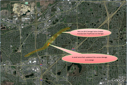
The first tornado from Saturday occurred at 10:58 PM in Burnsville near the intersection of McAndrews Road and Dakota County Road 5.
Narrative from the National Weather Service:
AN EF-0 TORNADO SPUN UP JUST NORTHEAST OF THE INTERSECTION OF COUNTY ROAD 5 AND MCANDREWS RD AND TRACKED NORTHEAST TO JUST SOUTHWEST OF THE INTERSECTION OF BURNSVILLE PKWY AND HWY 11. NUMEROUS TREES AND POWER LINES WERE BLOWN DOWN ALONG THE PATH...SOME FELL ONTO HOUSES. A STOP SIGN WAS BENT ALL THE WAY TO THE GROUND AND A GRILL LID WAS FLOWN ABOUT 200 YDS NEAR NICOLLET JR HIGH SCHOOL. MAXIMUM WIND SPEEDS WERE AROUND 80 MPH.
The velocity radar scan from 11:00 PM shows a small couplet along the I-35E corridor, evidence of a possible tornado. No warning was likely issued because of the time of the year, and severe weather threat was not highlighted by the National Weather Service. Since the activity was at night and brief in nature, an approaching tornado would have been difficult to detect visually. These tornadoes this day formed from low-topped convective activity similar to the August 19, 2009 series of tornadoes that caught many people off-guard, including the local National Weather Service office.
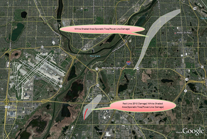
The second tornado occurred in Eagan seven minutes later to the northeast of the previous tornado. It spun up near the intersection of Skyline Drive and Minnesota Highway 13.
Narrative from the National Weather Service:
A BRIEF EF-0 TORNADO SPUN UP NEAR SKYLINE DRIVE EAST OF HWY 13 AND TRACKED NNE TO THE LOST SPUR GOLF COURSE JUST SOUTH OF I-494. NUMEROUS TREES WERE BLOWN DOWN AND EXHIBITED A CONVERGENT DAMAGE PATTERN. SOME TREES FELL ONTO HOUSES AND POWER LINES. OTHERWISE...LITTLE STRUCTURAL DAMAGE. ESTIMATED WINDS 75 MPH.
A couplet was more visually evident with the second tornado. Much like the Burnsville episode, no warning was issued even as reports of tree damage and power outages were coming into social networks. By the time reports came into the National Weather Service, the tornadic activity had dissipated. However, additional wind reports were still being received from the St. Paul area.
For a good ten minutes, the radar was hinting at the possibility of brief tornadoes:
Thankfully no one was serious hurt from the late year tornado that came at night, and without warning. If indoors and the storm sounds bad outside, always use common sense and head to the lowest floor. Each individual is ultimately responsible for his or her own safety.
RS


