Friday’s snow brought 2 to 2.5 inches of snow across the Twin Cities metro area, with some reports of three inches or greater in west central Wisconsin.
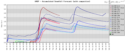
More snow is on the way for Monday. Early snow estimates from this storm indicate an average in the 1-3 inch range. This appears to be a storm that will have a bit of variation in the totals, depending on where you live. The NAM is printing out heavier snow across the eastern metro and across the St. Croix into west central Wisconsin.
Timing: The snow will start around midnight and will be coming down for the morning commute, so expect to be arriving to your destination a little bit later than normal. It will end late Monday night and I don’t expect the evening commute to be much better unfortunately.
Snow lovers have nothing to complain about this winter. With March generally being the snowiest month, there’s a good chance we could be flirting with seasonal snow record. With all the record-breaking events of 2010, nothing would surprise me anymore.
RS


No comments:
Post a Comment