Another warm and sticky day is on tap for Sunday as temperatures will soar into the 90s with dew points in the low 70s. A cold front will move in from the Dakotas and stall over the central part of Minnesota during the overnight hours into Monday.
The stalled front will lead to rainfall amounts around one inch with some isolated higher amounts northwest of the Twin Cities metro.
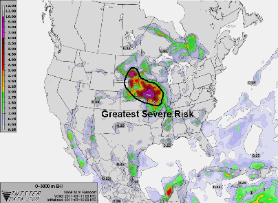
The severe weather set up appears to be better defined going into Sunday, but I’m expecting the severe weather to stay well to the west and south of Minnesota. Highlighted below is the area where I believe the greatest concentration of severe weather will occur. High winds and large hail will be possible across the entire area of severe risk. A tornado threat will exist across northeast South Dakota, around the Aberdeen area, due to higher wind shear values forecasted into Sunday night.
As the storm activity crosses the border into Minnesota from South Dakota, the storm will evolve into a complex or line, referred to as a mesoscale convective system (MCS). This will trigger the heavy rains that the forecast models are indicating around the midnight hour across the central portion of Minnesota. We may be dealing with additional flash flood warnings. Stay tuned!
RS


No comments:
Post a Comment