A bout of severe thunderstorms and heavy rain look to be on tap for Tuesday across Minnesota.
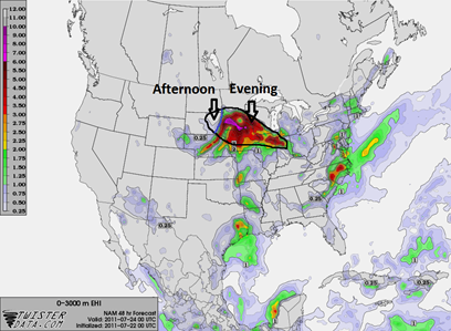
A warm front is slowly projected to move eastward from the Dakotas into the western part of Minnesota by the evening hours:
Along the southern periphery of the progressing warm front is where the greatest instability will be in place, setting the stage for isolated thunderstorms capable of producing large hail and damaging winds. No widespread outbreaks expected, and the tornado risk is small, with the best chance across central Minnesota. During the afternoon, northeast South Dakota will be in line for severe weather first in the vacinity of the warm front, and as the front shifts to the east, southwest Minnesota will see the chances for strong to severe storms after 7 PM. The Twin Cities should see storms by around midnight, or shortly thereafter.
The models are also indicating heavy rain across northern Minnesota through Wednesday night. Anywhere from one to two inches of rain may fall from the storms as they pass through the area.
Most of Minnesota is already near normal for precipitation. It's areas across the southern United States that need the rain the most as a historic drought is ongoing. Texas is experiencing it’s third-worst drought since 1895.
Stay tuned to StormChaser Schwartz through the day for further developments!
RS


No comments:
Post a Comment