Saturday is shaping up to be a stormy one across Minnesota during the afternoon and evening hours as a cold front will move through the state and be positioned in Wisconsin by early Sunday morning. It will bring with it a drop in high temperatures between Saturday and Sunday by 10-degrees, and a noticeable dip in dew points into the comfortable 50s. Unlike most of the weather setups during the late spring into the summer, this one will be more of a textbook setup. Here is the surface analysis at 7 PM Saturday:
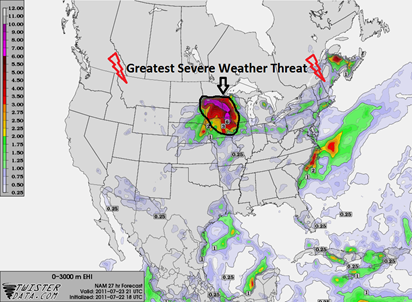
Ahead of the cold front, temperatures will be in the low to mid-90s with dew points in the mid-70s. This will create a very unstable atmosphere for the cold front and associated low pressure area to work with during the day. Highlighted below is the greatest risk area for severe thunderstorms. It covers about the southern two-thirds of the state. Large hail and damaging winds will be the primary threat in this area.
This is roughly the same outline where the Storm Prediction Center indicated a slight risk of severe weather for Saturday in it’s Day 2 outlook, issued at 12:30 PM Friday.
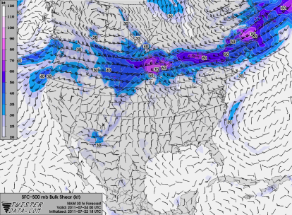
The strongest wind shear will be along the northern periphery of the severe risk area, roughly between Brainerd and St. Cloud, Minnesota.
That area in the north-central part of Minnesota will see the risk of tornadoes with wind shear values in the 60 to 70 knots range. That’s a lot of speed, folks!
U2 concert goers heading to TCF Bank Stadium on the University of Minnesota campus should pay close attention to the skies Saturday night and head for shelter if skies appear threatening. I have plans to attend another concert that night, but I will likely be out watching the storms as they approach the Twin Cities. Having nearly 60,000 people packed into an outdoor stadium with severe weather looming is a worst nightmare to anyone associated with weather and public safety. However, if spotters and chasers are able communicate and collaborate effectively with weather service and media personnel, then providing advanced warning should go off without a hitch. One positive working in emergency managers’ favor is that the tornado threat appears to be away from the metropolitan area, and outdoor concert events.
Stay safe, and have a great weekend!
RS


Hi Ryan, nice post.Maybe Ill see you out there!
ReplyDelete