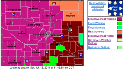
A tremendous amount of heat will be arriving into Minnesota within 24 hours, and will last for several days. Temperatures will be well into the 90s through Wednesday of next week with high humidity. Dew points will above 70-degrees, making it feel quick sticky out there. This combination will lead to dangerous heat index values above 100-degrees. As a result, the National Weather Service in Chanhassen has issued an Excessive Heat Warning for the Minnesota counties and a few Wisconsin counties the office serves until 9 PM Wednesday. Additional Wisconsin counties are expected to be added by this afternoon.
... Excessive heat warning remains in effect until 9 PM CDT
Wednesday...
An excessive heat warning remains in effect until 9 PM CDT
Wednesday.
* Temperature... afternoon highs in the lower to middle 90s with low temperatures in the middle to upper 70s
* heat index... 105 to 110 degrees in the afternoon and early
evening.
* Impacts... these hot and humid conditions will lead to a
heightened risk of heat related stress and illnesses.
Precautionary/preparedness actions...
Take extra precautions if you work or spend time outside. When possible... reschedule strenuous activities to early morning or evening. Know the signs and symptoms of heat exhaustion and heat
stroke. Wear light weight and loose fitting clothing when
possible and drink plenty of water.
To reduce risk during outdoor work... the occupational safety and health administration recommends scheduling frequent rest breaks
in shaded or air conditioned environments. Anyone overcome by heat should be moved to a cool and shaded location. Heat stroke is an emergency... call 9 1 1.
An excessive heat warning means that a prolonged period of
dangerously hot temperatures will occur. The combination of hot temperatures and high humidity will combine to create a dangerous situation in which heat illnesses are likely. Drink plenty of fluids... stay in an air-conditioned room... stay out of the sun...and check up on relatives and neighbors.
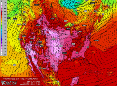
Looking at the overnight NAM models, here is the temperature map for Sunday showing the bulk of hot air surging northward. Click the image below to enlarge. Temperatures will be very close to 100-degrees for southern Minnesota. For the Twin Cities, my thinking is that the high temperature will top off at around 98-degrees. This will be dependent on the amount of cloud cover in the area, which can be difficult to predict days in advance.
Monday is looking quite steamy as well with another day of temperatures in the upper 90s. Click the image below to enlarge.
The National Weather Service Hydrometeorological Prediction Center heat index forecast indicates heat index values hitting 110-degrees in Minneapolis-St. Paul (MSP) on Monday.
Interpreting forecast data, the Hydrometeorological Prediction Center believes MSP has a 62% chance of seeing heat index values in excess of 105-degrees during the day on Monday.
Make sure to drink plenty of water and your A/C is tuned and ready to go with the heat index likely in excess of 105-degrees!
RS


No comments:
Post a Comment