Showing posts with label education. Show all posts

Thursday, July 21, 2011

Why no tornado with “hook echo” on Tuesday storms?

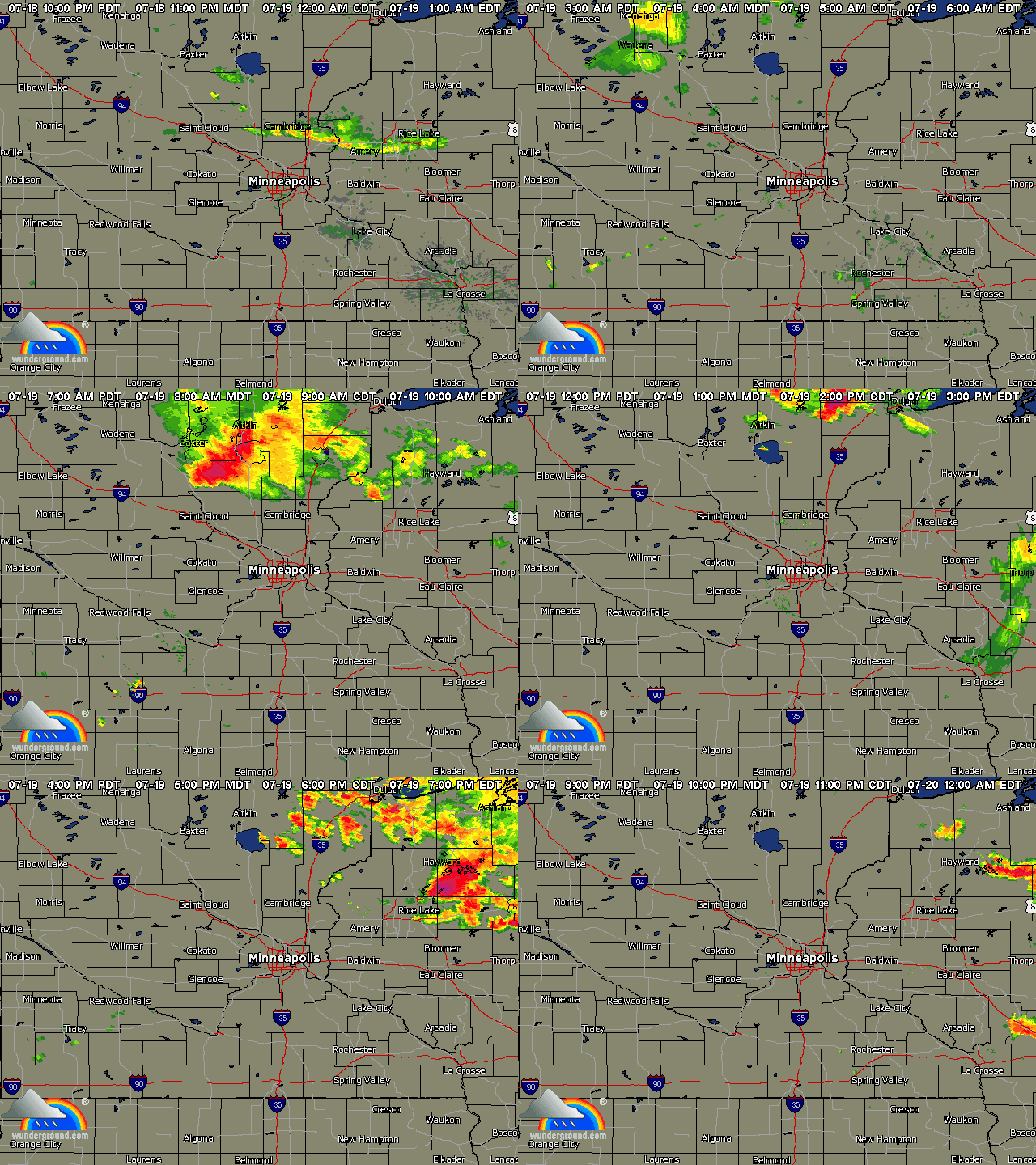
During the morning hours of Tuesday, July 20th, a supercell thunderstorm tracked from the Brainerd area southeastward through the Twin Cities.

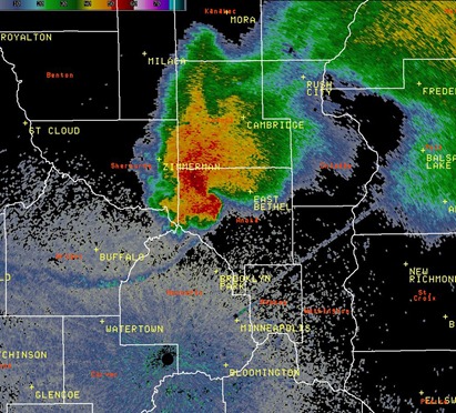
WUNIDS_composite_archive

As the storm ascended on the Twin Cities metro, it began to show instances of hook echoes on radar.  A hook echo is an indicator of tornado development.  Here is a radar image that the National Weather Service in Chanhassen put together of a hook appendage in northwestern Anoka County at 10:45 AM.  No tornado reports with this, but there was a public report of a funnel cloud about 15 minutes later at 11:02 AM in Maple Grove near the Interstate 494 and 694 junction.

11July19_1545Z

Radar was not picking up real strong rotation with this storm on the velocity scans that detect wind from different directions.  This may have been one of the reasons why a tornado warning was not issued:

MPX_N0V_1107191559_912x684_none__0865

At first, I believed the funnel report was legitimate based on what I was seeing on radar at the time. However, as I was able to analyze the storm dynamics later, and seeing the storm first hand over my lunch break at work, I began to discredit the report.  It appears the funnel was mistaken for the low, ragged clouds present with this storm.  These are called scud clouds, which are nothing more than scary looking “junk” clouds that pose no immediate threat.  This can often fool an untrained eye.

The sky also grew massively dark as the large cell completely covered the sunlight from the east, and it made people aware there was something brewing off in the distance.  Here is video I found on YouTube of the storm as it rolled through:

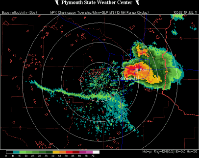
The supercell with another apparent hook, as it appeared on radar, tracking through the Minneapolis and St. Paul downtowns and southward towards the Minneapolis-St. Paul International Airport at 11:59 AM:

MPX_N0R_1107191659_800x600_none__0865

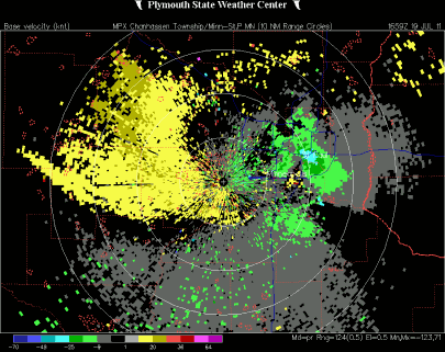
Again, radar was not showing any areas of tight rotation with this storm on the velocity image that detects wind from different directions.  The storm was a little better organized than earlier, but still no indicators of danger.  It’s difficult for National Weather Service personnel to issue a tornado warning when there is no real evidence of a developing tornado.  Although it’s best to err on the side of caution, you don’t want a “cry wolf” scenario to develop, and no one ends up heeding the warning.  When NEXRAD was installed in the mid-90s to replace archaic World War II basic radar technology, velocity scans were one of the radar products introduced that provided clues to meteorologists as to the areas of greatest rotation that could eventually lead to tornado development.

MPX_N0V_1107191659_912x684_none__0865

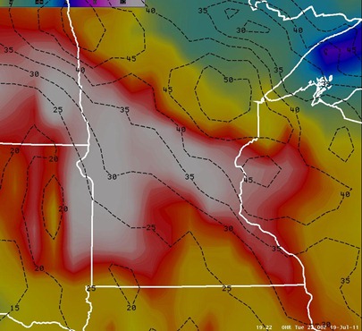
So we had the classic “hook” show up on radar, but why wasn’t there any rotation?  Wind shear was not particularly strong this day as values were 40 knots across the thunderstorm area.  For tornadoes to form, strong sheer must be present.  In terms of speed, typically wind shear in excess of 40 knots is a good starting point.  Although the image below is from later in the day at 5 PM, it is fairly representative of the wind shear present (noted in black) throughout the day on Tuesday.  Shear was between 30 and 40 knots during the day across most of Minnesota.

11July19_svr

The Storm Prediction Center noted in it’s 7:30 AM outlook the primary threats as large hail and damaging winds across Minnesota, but veering winds brought an isolated tornado threat to the area.

DEEP-LAYER VERTICAL SHEAR WILL NOT BE PARTICULARLY STRONG /I.E. LESS THAN 35 KT/...HOWEVER VERTICALLY VEERING WINDS INVOF SURFACE BOUNDARY WILL SUPPORT ORGANIZED STORM STRUCTURES CAPABLE OF LARGE HAIL...DAMAGING WINDS AND PERHAPS A TORNADO.

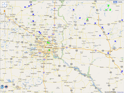
Due to the weaker wind shear, the storm reports received throughout the day where primarily from damaging winds across central Minnesota and western Wisconsin, but some hail reports were mixed in as well:

Capture

Hopefully this post helps explain why the storm was more impressive on radar, and that it had more “bark than bite”.  Had better wind shear been present, a main ingredient for tornadoes, this could have been a very dangerous situation with perhaps a tornado near St. Paul and MSP airport.  I don’t believe Minneapolis and St. Paul proper have been hit by different tornadoes in the same year.  In my opinion, we dodged another close call for metropolitan storms in what would have been another bullet point in this whacky year of weather extremes that is 2011!

RS
Friday, July 8, 2011

Shelf cloud vs. Wall cloud: Part Deux

Due to an overwhelming response to the Weather 101: Shelf cloud vs. Wall cloud post, I’ve decided to post some additional shelf cloud and wall cloud examples that were supplied to me with permission by fellow weather enthusiasts to illustrate proper cloud identification.

Each cloud type has different characteristics to provide clues as to what kind of weather can be expected in the short-term, so accuracy is important.  As discussed in the original post, an approaching shelf cloud is a strong indication of very gusty straight-line winds that can pose a safety hazard.  Straight-line winds have been known to reach or exceed 100 MPH, which is equivalent to an EF-1 tornado!  A nearby wall cloud means residents should be prepared to take cover.  Wall clouds are typically rotating, and are sometimes a pre-cursor to funnel clouds, which may eventually produce a tornado if the funnel extends all the way to the ground.

Wall cloud examples:

 Michael Thompson took this photo of a wall cloud near Crookston, MN on July 4, 2011.  Notice the distinct lowering of the cloud base.  (For great storm photos, I recommend following Michael’s blog.  His photos are professional, high quality.)


Wall cloud approaching downtown St. Paul, Minnesota from June 21, 2011. Video by David Blume, KD0IRF.

Shelf cloud examples:

 Michael Thompson took this photo of a shelf cloud rolling in near MSP airport on July 1, 2011.

Video shot by Michael Thompson of a shelf cloud approaching MSP airport on July 1, 2011.

As I was discussing this matter with Michael, he pointed out that a shelf cloud looks like a huge wall coming at you.  This is very true, and a big reason why the mistake in identity happens.  Hopefully, this additional media makes it easier to understand the differences between a shelf and wall cloud, so when severe weather occurs close to your neighborhood, you will know what kind of weather to expect!  I would like to personally thank Michael and David Blume for their outstanding contributions on this topic.  It’s amazing what a little collaboration and help among weather enthusiasts can do.  We all learn from each other, and in turn, it becomes a tighter knit group.  I cherish what I have learned from weather spotters, chasers, and enthusiasts that I have encountered over the last few years.  It’s truly amazing.

RS

Sunday, July 3, 2011

Weather 101: Shelf cloud vs. Wall cloud

With the Friday night storms that moved through the Twin Cities area, there were many calls from the public into “The Good Neighbor” and folks on Twitter reported seeing a wall cloud close to their location. Was it actually a wall cloud? No. What these people were actually seeing was a shelf cloud with the line of storms. A couple friends pointed out to me when I arrived home from following the storms that even television media outlets were not immune from making this error while posting images.

I felt compelled to write this post to help educate what is being seen in the sky to avoid confusion in the future. At the end of the day, does all of this make a huge difference? No, but I think accuracy counts, and it makes it easier to listen to reports on the radio when they are 95% correct rather than 95% wrong. What I’m not going to do is “call out”, because quite frankly, a lot of people out there simply don’t know the difference, and it would be arrogant of me to do so otherwise. One of my goals as being a storm spotter is connecting with the public and educating people that see my work through my blog or social media websites, so they have a better understanding and appreciation for weather. I try to present weather as a fun, interesting, and informative topic. It can actually be pretty cool!

So without further ado, here is the difference between the two cloud formations:

shelf_over_mpx_JohnWetterShelf cloud at the National Weather Service in Chanhassen

The shelf cloud is horizontally elongated, and it’s something you typically see with a line of storms rather than an individual supercell thunderstorm. Winds are blowing away from a shelf cloud – known as the outflow. The National Weather Service defines it as, “A shelf cloud is a low, horizontal wedge-shaped cloud, associated with a thunderstorm gust front (or occasionally with a cold front, even in the absence of thunderstorms). A rising cloud motion often can be seen in the leading part of the shelf cloud, while the underside often appears turbulent, boiling, and wind-torn.”

wallcloudWall cloud image from the National Weather Service

Whereas the shelf cloud has more of a horizontal feature to it, a wall cloud on the other hand is a vertical lowering of the cloud base. These are what you see with rotating supercell thunderstorms, and are often a pre-cursor to funnel clouds and tornadoes if the conditions are just right. Winds are blowing towards a wall cloud – known as the inflow. The National Weather Service defines it as, “A wall cloud is a cloud formation associated with thunderstorms. It is a definite lowering of the cloud base typically beneath the rain-free portion of a cumulonimbus cloud, and indicates the area of primary and strongest updraft which condenses into cloud at altitudes lower than that of the ambient cloud base. Sometimes, the wall cloud will often be seen to be rotating. A rotating wall cloud is the area of the thunderstorm which is most likely to produce tornadoes, and the vast majority of intense tornadoes.”

Hope you found this to be informative for when you see weather roll in next time, you will know exactly what you are looking at!

RS