Here is comprehensive look at snow totals from across the state on Saturday. The Saturday midday NAM output did a fairly good job at projecting snow amounts for this storm. The storm track appeared to shift 25 to 35 miles further to the northwest than what the model suggested, which brought four and a half to five inch snows to Dakota County in the southeastern Twin Cities metro. With the shift, this was slightly higher than the four inch snows I forecasted across this area. Snow totals in excess of five inches were common across south central and southeast Minnesota. This area I believed would see four to six inches, which verified to the reports. As expected, there was a sharp cutoff to the snow towards the northwest. Snow generally fell south of a line from Marshall, to St. Cloud, to Moose Lake.
In my own backyard in Shakopee, 4.3 inches of snow had accumulated before midnight on Saturday, but I was not able to take another measurement before the end of the snowfall and subsequent snow melt Sunday morning. It was not included in the final snow totals report from the National Weather Service in Chanhassen.
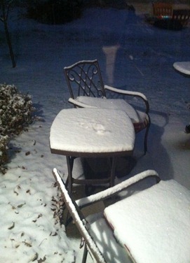
Here was the scene in the backyard Saturday evening as an inch of snow had already fallen.
Other Minnesota locations listed by amount, city, and county:
- 6.00, SPRING VALLEY 3E, FILLMORE (Golden Shovel Award)
- 5.50, ELLENDALE, STEELE
- 5.50, MAPLETON, BLUE EAR
- 5.40, WABASHA, WABASHA
- 5.20, WINONA, WINONA
- 5.20, HASTINGS, DAKOTA
- 5.20, NORTH MANKATO, NICOLLET
- 5.00, WINONA 4SW, WINONA
- 5.00, MINNESOTA CITY, WINONA
- 5.00, FAIRMONT, MARTIN
- 5.00, 1 WSW LITTLE CANADA, RAMSEY
- 5.00, RED WING, GOODHUE
- 4.90, THEILMAN, WABASHA
- 4.80, AUSTIN 1W, MOWER
- 4.50, HARMONY, FILLMORE
- 4.50, 3 SE MAPLEWOOD, WASHINGTON
- 4.50, 1 ENE INVER GROVE HEIGH, DAKOTA
- 4.50, 3 SE LAKE ELMO, WASHINGTON
- 4.50, 1 S BLUE EARTH, FARIBAULT
- 4.50, INVER GROVE HEIGHTS, DAKOTA
- 4.50, 3 SSW BURNSVILLE, DAKOTA
- 4.50, 1 NNW OWATONNA, STEELE
- 4.40, 3 N BURNSVILLE, HENNEPIN
- 4.40, MINNEAPOLIS MSP AIRPORT, HENNEPIN
- 4.30, 4 E NERSTRAND, GOODHUE
- 4.30, 1 NNW NORTH ST PAUL, RAMSEY
- 4.30, 2 W PRIOR LAKE, SCOTT
- 4.30, CREDIT RIVER, SCOTT
- 4.30, 2 W PRIOR LAKE, SCOTT
- 4.20, 1 SSE BLOOMINGTON, HENNEPIN
- 4.20, 1 S HAMPTON, DAKOTA
- 4.10, 1 ENE BLUE EARTH, FARIBAULT
- 4.00, ASKOV, PINE
- 4.00, ALTURA 5W, WINONA
- 4.00, GRAND MEADOW, MOWER
- 4.00, LYLE 2NE, MOWER
- 4.00, PETERSON 1S, FILLMORE
- 4.00, PRESTON, FILLMORE
- 4.00, 3 W NEW ROME, SIBLEY
- 4.00, 1 E OWATONNA, STEELE
- 4.00, 2 N WOODBURY, WASHINGTON
- 4.00, WINNEBAGO, FARIBAULT
- 3.90, 1 W CARVER, CARVER
- 3.70, 2 SSW LAKEVILLE, DAKOTA
- 3.70, 3 SE NEW ULM, BROWN
- 3.60, ROCHESTER AP 2NE, OLMSTED
- 3.50, 4 SSW MINNEAPOLIS, HENNEPIN
- 3.50, 1 SW EDINA, HENNEPIN
- 3.50, CHANHASSEN, CARVER
- 3.50, 1 NE MINNEAPOLIS, HENNEPIN
- 3.50, MADELIA, WATONWAN
- 3.40, ROCHESTER AIRPORT, OLMSTED
- 3.40, BLOOMINGTON, HENNEPIN
- 3.30, AUSTIN KAAL TV, MOWER
- 3.20, CANNON FALLS, GOODHUE
- 3.20, CHANHASSEN WFO, CARVER
- 3.10, ELGIN, OLMSTED
- 3.00, LAKE CITY COOP, WABASHA
- 3.00, 1 ENE RICHFIELD, HENNEPIN
- 3.00, 1 NE ZUMBROTA, GOODHUE
- 3.00, EDEN PRAIRIE, HENNEPIN
- 3.00, 2 NNW RED WING L/D3, GOODHUE
- 2.90, 2 NW CHASKA, CARVER
- 1.60, SPRING GROVE 4N, HOUSTON
- 1.30, LA CRESCENT DAM 7, WINONA
- 1.00, 14 W ISABELLA, LAKE
- 1.00, BRUNO, PINE
- 0.90, HOLYOKE, CARLTON
- 0.60, 5 NNE TWO HARBORS, LAKE
- 0.60, 9 NNE HERMANTOWN, ST. LOUIS
- 0.50, 2 E FINLAND, LAKE
- 0.50, 6 NW DULUTH, ST. LOUIS
- 0.40, WRENSHALL, CARLTON
- 0.20, 1 SW TOFTE, COOK
- 0.10, 3 E PAYNE, ST. LOUIS
RS


No comments:
Post a Comment