Saturday, December 31, 2011

Freezing precipitation this morning

Some freezing precipitation is being reported in the Brainerd area, and locations to the east this morning.

mixedprecip

From the National Weather Service in Duluth:

AT 900 AM...SNOWFALL SPOTTERS AND AUTOMATED WEATHER STATIONS WERE REPORTING FREEZING FOG AND FREEZING DRIZZLE IN THE BRAINERD AND NISSWA AREAS. AS TEMPERATURES WARM ABOVE FREEZING THROUGH THE NOON HOUR...THE FREEZING DRIZZLE AND ICY CONDITIONS WILL DIMINISH. IF TRAVELING...SLOW DOWN AND ALLOW FOR EXTRA TIME TO REACH YOUR DESTINATION. LIGHT SNOW AND POSSIBLE REDEVELOPMENT OF SOME FREEZING DRIZZLE WILL BE POSSIBLE OVERNIGHT.


RS

Winter Storm Warning?

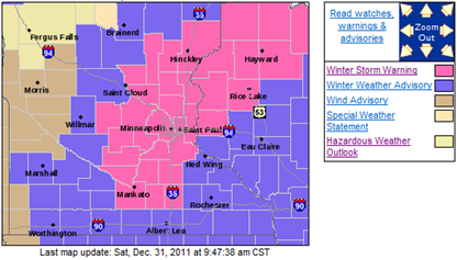
Much to my surprise this morning, on the final day of 2011, Winter Storm Warnings have been posted issued for a good portion of east central Minnesota into northwest Wisconsin.

  • Winter Storm Warning valid at Dec 31, 9:00 PM CST for Anoka, Chisago, Dakota, Hennepin, Isanti, Le Sueur, Ramsey, Rice, Scott, Steele, Waseca, Washington [MN] and Barron, Polk, St. Croix [WI] till Jan 01, 6:00 AM CST
  • Winter Storm Warning valid at Dec 31, 4:00 PM CST for Pine [MN] and Burnett, Douglas, Sawyer, Washburn [WI] till Jan 01, 12:00 PM CST

warningmap

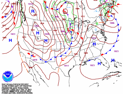
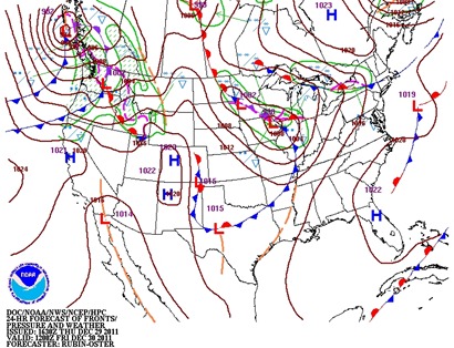
A low pressure center and associated cold front is expected to move on top of southern Minnesota by the evening hours, generating precipitation and gusty winds along with it.

92fwbgus

This storm system is forecasted to have up to a half-inch of of liquid precipitation to work with.  The precipitation will start as rain before changing over to snow by around midnight.

fill_94qwbg

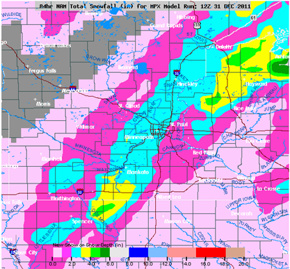
The latest NAM is spitting out generally one to three inches of snow across the Twin Cities.

NAMsnow12312011

This will be a wet snow, so I think a range of one to three inches of snow across the Twin Cities seems like a real possibility.

snowratio12312011

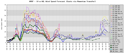
Winds will be kicking up towards midnight with sustained winds between 20-30 MPH with gusts to 40 MPH or higher!  This will result in some blowing snow and reduced visibilities.  Fortunately, we are not looking at a ton of snow, so it should not be too much of a problem.

winds12312011

Stay safe on this New Year Eve and don’t drive home drunk.  Have a sober ride lined up.  The weather conditions will be a challenge during the overnight for even the sober of drivers.

RS

Thursday, December 29, 2011

Weather notes from this week

Monday saw the mercury reach 52 degrees in the Twin Cities, which was a new record for the day. The previous record was 51 degrees set in 1936. We have been in the 50s before in December. In 1999, we set a record high temperature of 53 degrees for December 29th.

The DNR is warning us about fire danger. Yes, in December, folks. Unbelievable. Sometimes I have to ask myself which season is it again. Winter, spring, or fall? Not every year do you see green grass in some places before Christmas.

RS

One last snow hurrah for 2011?

In what perhaps will be the final snowfall of 2011, several locations across the southern half of Minnesota may pick up at least an inch of snow by midday Friday as a couple low pressure areas and associated front drag across the region.  Temperatures will slip just enough below the freezing point for snowflakes.  We’re not talking anything significant (>4 inches) by any means.

94fwbgus

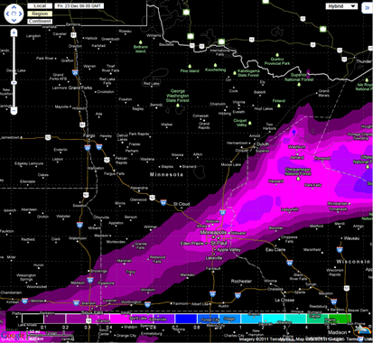
Moisture content will be meager, with the heaviest of the snow falling across far southeastern Minnesota.  The concentrated areas of snow will fall south of Interstate 94.

fill_94qwbg

The European model picks up on the moisture in far southern Minnesota in determining snow amounts.

euro

In Rochester, the models seem to be agreeing on an amount in the three to four inch range.

RSTsnow

In the Twin Cities, expect lighter snow.  Right now, I thinking generally most areas in the metro will see about two inches of snow will some isolated areas, mainly south, seeing up to two-and-a-half inches.

GFSsnow12292011


SREFsnow12292011

Expect a slow commute Friday morning.  The timing of the snow appears to be in a window between midnight and 9 AM.

RS

Tuesday, December 27, 2011

Top 5 Minnesota weather events of 2011

As 2011 wraps up, it was another historic year in weather filled with extremes.  Some of the year’s events include tornado outbreaks across the southern United States, and closer to home, a top five snowfall for the 2010-11 season, humid summer, highest peak wind gust recorded in state history, a tornado in Minneapolis, and record fall drought.  In reflection on 2011, here are my top 5 weather events for the year.  The top events as voted on by the Minnesota Climatology Working Group are here.

#5 Minneapolis tornado

Note: While this event was listed number one by Minnesota Climatology Working Group, this list presented here was weighted on the significance of unusual events that are often historic.  While this tornado impacted a lot of people in a populated area, the damage was relatively minor compared to tornado outbreaks across the central and southern United States during the spring.

The second tornado to hit Minneapolis in three years occurred on May 22th, and would be later classified by the National Weather Service in Chanhassen as a high-end EF-1. The tornado killed one person and injured 48 while it was on the ground for 14.25 miles from St. Louis Park to Blaine. The heaviest concentration of damage was confined to north Minneapolis.  The majority of the damage was downed trees atop buildings and vehicles, however the twister did demolish garages, sheds, and rooftops at during peak strength.

The supercell that produced the twister was part of a larger storm extending from northeastern Oklahoma, and through the Mississippi Valley to northern Wisconsin. There were 56 reports of tornadoes across the United States this day with the strongest one affecting Joplin, Missouri. 162 people lost their lives, and thousands were displaced from their homes as large sections of the city were leveled.

Additional reading:

#4 Humid summer

319 hours of dew point temperatures of 70 degrees or higher was recorded at the Twin Cities International Airport this summer, and a record was set for dew point temperatures of 75 degrees or higher with 103 hours.  On July 19th, the dew point temperature reached 82 degrees at the Twin Cities, breaking the old record of 81 that was set on July 30, 1999.  In addition, the highest dew point temperature recorded in Minnesota was set this day at the Moorhead Airport with 88 degrees, breaking the old record of 86 that was set at both Pipestone and St. James on July 23, 2005.

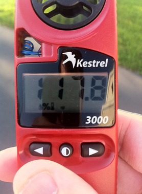
Shortly after 7 PM on July 19th, I recorded a heat index reading of nearly 118°F at my home in Shakopee.  Temperatures were into the 90s, with dew points hovering around 80 degrees.
IMG_0642

#3 Record wind speed in Donaldson

The first day of September and the meteorological autumn season brought severe thunderstorm winds across northwestern Minnesota as temperatures climbed into the 90s with dew points into the 70s.  An automated station a mile west of Donaldson in Kittson County recorded a wind gust of 121 MPH during the early morning hours.  This measurement was substantiated by damages inflicted in the surrounding landscape by such strong winds.  Two large commercial grade steel bins were torn out from the local grain elevator, and the significant tree damage in the area matched winds of that extreme range.  The National Weather Service, Minnesota State Climatology Office, and National Climatic Data Center tested the data collected from this station and later confirmed 121 MPH reading - the strongest wind speed ever measured in Minnesota.  The old state record wind speed was 117 MPH from a thunderstorm near Alexandria, MN back on July 19, 1983.  While wind speeds of this magnitude, and higher have likely occurred in Minnesota in the past, there was not any instrumentation that survived to record the wind speed.  According to Dr. Mark Seeley, the wind in Donaldson was measured by an R.M. Young Wind Monitor (aero vane), a mechanical, propeller type instrument. The actual instrument is said to have a measurement range up to 224 MPH.

#2 Record fall drought

1.36 inches of liquid precipitation fell from September 1 to November 30 in the Twin Cities, which made it the driest autumn since records began in 1871.  The entire state saw below normal precipitation for the season.  On a larger scale, the lack of rain during the fall continued the ongoing drought across much of Minnesota since late summer.  Sections of southern and western Minnesota are depicted by the U.S. Drought Monitor as falling in “moderate” to “severe” drought categories.

p20110901-20111128d_bigger

#1 Fourth snowiest snow season on record

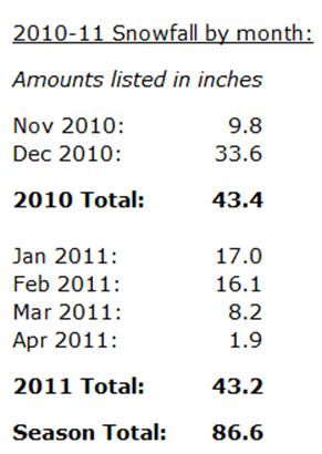
The top event of the year goes to snow.  The snowy trend carried into 2011 from December 2010 as we saw roughly the same amount of snow in the Twin Cities during the first four months of this year as we did in November and December of the previous year. 
image

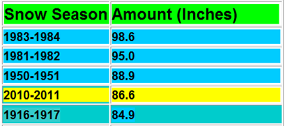
By the time the snow ended for the season, MSP recorded the fourth highest total on record with 86.6 inches.
snowrecord

February snows on the 20th and 21st shattered more climatological records.  We witnessed the largest single snowstorm for the month in the Twin Cities since 1891 with an official total of 13.8 inches. A foot was recorded at my home in Shakopee, and I put together a time lapse of the snow as it feel in the backyard.

Along with the top five list, here are my storm chasing highlights from the year.  Across Minnesota, it was a quiet year compared to 2010 with fewer ideal setups for severe storm initiation.  As a result, fewer tornadoes were reported in 2011 (31) than the 30-year historical average (37).  There seemed to be one ingredient missing or interference of mesoscale dynamics in these setups that prohibited storms from being really explosive this year.

Do you agree with my rankings?  How would you rank the top five events from Minnesota?  Share your thoughts below.  I would also like to thank everyone that stopped by this site this year.  Hopefully you learned a little bit about the weather this year, and look forward to your support in 2012!

RS
Sunday, December 18, 2011

The Best of Christmas Lights 2011

Here are some of my best Christmas lights shots of 2011.  These were taken on a Nikon D5000 with a Manfrotto tripod.

The first set comes from WaconiaChristmas.com.  It is located at 1729 Park Point Road in Waconia.  The lights are synchronized to music playing on 97.7 FM.

001

002

005

010

The second set comes from Christmas at the Fischer's Place. It is located at 16700 33rd Ave North in Plymouth. The lights are synchronized to music playing on 103.3 FM.

008

013

014

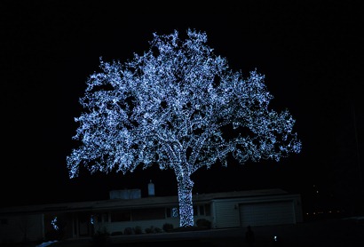
The third set comes from Bob and Julie Little's 55-foot oak tree on Meadowview Road in Bloomington. Overlooking the Cedar Avenue (Minnesota State Highway 77) Bridge, this tree has become a wintertime landmark for commuters, Twin Cities residents, and even pilots and passengers on planes approaching MSP from the south.  The tree contains over 49,000 lights made up of blue LEDs.

024

026


Hope you have enjoyed the photos!

RS

Saturday, December 17, 2011

Warm weather ahead; Christmas snow looks less likely

A mild week is on tap for next week as high temperatures will be running above average through Christmas.  We could be in the 40s on Sunday with temperatures in the 30s as the week’s theme.

temps

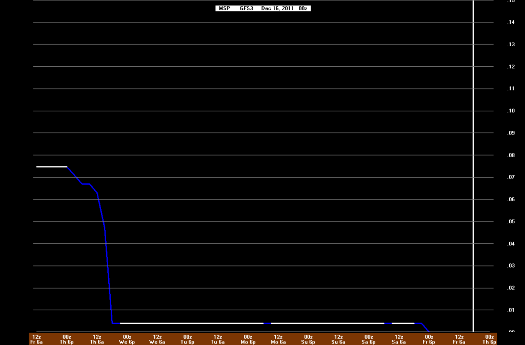
With the warm air, this will keep the snow chances low through the end of the week.  The GFS is not suggesting any snow through Christmas Eve based on the latest model run:

GFSXmasBufkit

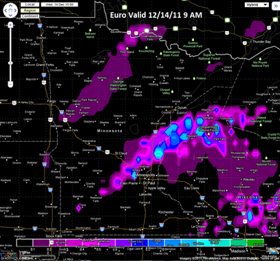
The European model was keeping a pre-Christmas dusting of snow in the forecast as of last night’s model run.  Still awaiting the mid-day Saturday model run.  This will be last chance of snow.  Based on the mild temperature profiles, I‘m favoring the GFS at this moment.  The odds of a snowless Christmas are looking better each day.

Euro

While we had nowhere to dump snow last year, it’s a whole different animal this year.  Lawns are being to green from the recent rainfall on Wednesday, and golf courses have the added benefit of staying open longer this year.  On the other hand, it hurts businesses that depend on snow – snow removal services and retailers, snowmobile dealers, and sporting good retailers of winter equipment and gear. In already tough economic times, this certainly is not welcome.

RS

Friday, December 16, 2011

Where is all the snow?

From the December 16, 2011 Shakopee Valley News’ The WeatherDesk

As you may have noticed, we no longer have any snow on the ground thanks to our recent mild temperatures. Although the ground is bare, we are not far from the historical benchmark of 10 inches of snow for December. Officially, 7.9 inches of snow has fallen this month at MSP Airport, and I've seen 7.1 inches unofficially in Shakopee. Unofficial in that I'm not always around to measure the snow, and I do require sleep once in a while for the overnight snows!

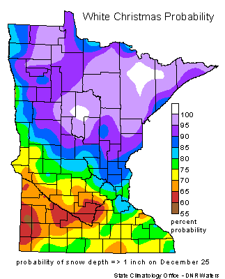
About this time last year, we saw our historical snowfall that brought 21.5 inches of snow to Shakopee (and apparently made famous by CNN), and at least 18 inches to other parts of the Twin Cities. The weight of the snow caused the roof to collapse at the Metrodome, er, Mall of America Field. A video you've probably seen many times. We have been presented with much different conditions this year with rain, yes, rain in December, that feel on Wednesday. It was much needed for the drought-stricken soil. 0.37 inch of rain total fell from this storm system, and you have to go back nearly three months to October 12th when we last received at least that much rain. Had the air been about 10 degrees cooler, we may have seen up to a half foot of snow. Mostly likely would have been in the four to six inch snow range. This would have eliminated the concern of a Brown Christmas. We have a White Christmas in he Twin Cities about 75 percent of the time. The last Brown Christmas was in 2006, so we are statistically due to see another one. As you might expect, the odds are better of seeing a White Christmas as you travel north towards the Arrowhead region where a probability of 90 percent or greater exists.


What does Christmas hold for us in terms of seeing snow? That seems to be the $64,000 question raised by local weather media. I feel it’s too soon to completely write-off a White Christmas by the big holiday. For those wishing for snow, anxiety is beginning to kick in as we count down the days to the 25th. Forecasts can and do change rapidly, and sometimes snowstorms only appear three days out from the onset. There has been a lot of fluctuation with the models in regards to snow chances next week. At one point, snow was in the forecast for Monday, but that has all but been eliminated. Just recently, there were hints of snow on Christmas Eve, but that projection was moved up to Thursday. This may be the last shot for a White Christmas.

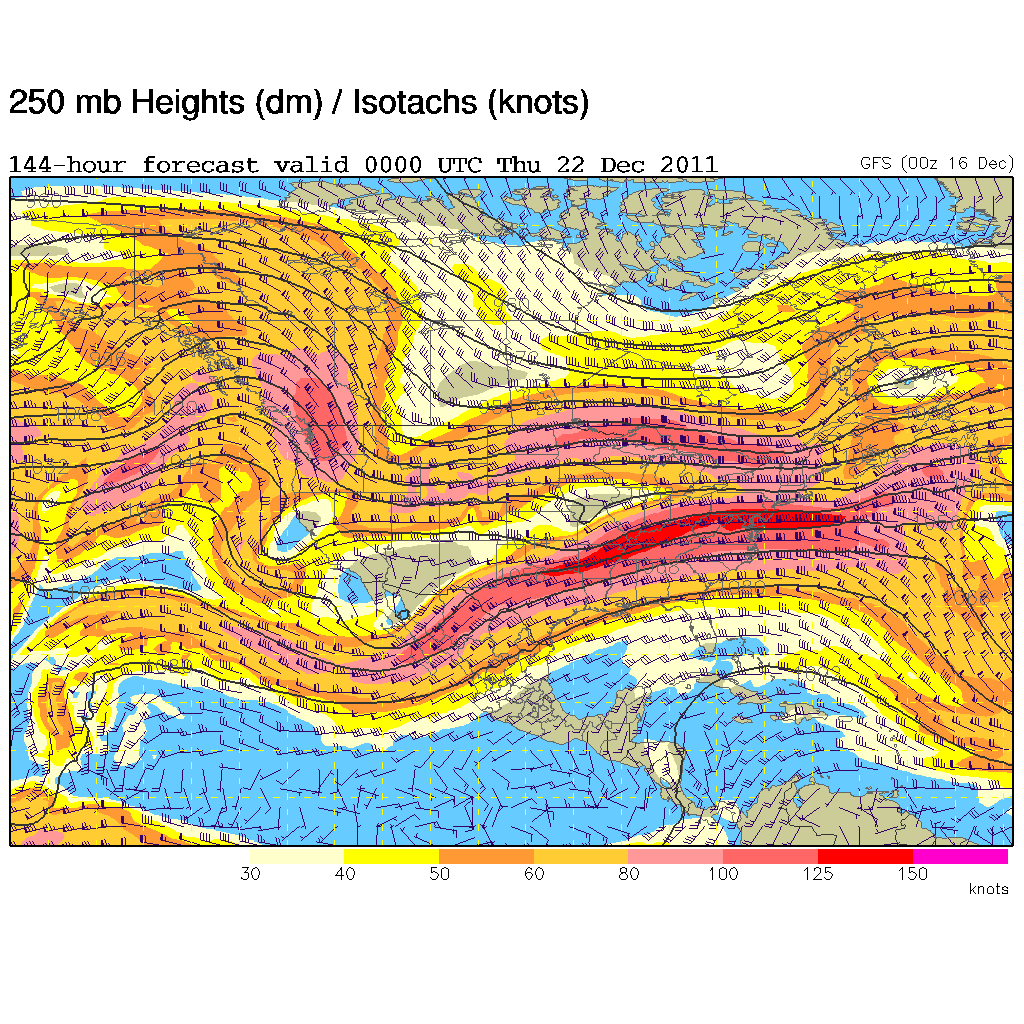
So what is my prediction? Drumroll, please. If I was a betting person, I would say that we have a Brown Christmas. I'm going to go with an 80 percent chance of that happening. There just are not any definite signs that says a snowstorm is on it's way. The jet stream shows signs of an El Nino weather pattern rather than a La Nina one with a "split flow" across the northern and southern states, which may be partially responsible for our mild weather this year.


For snow lovers, keep your fingers crossed, but the odds favor a Brown Christmas this year. Still plenty of time for things to change!

RS
Tuesday, December 13, 2011

Too early to declare a “brown” Christmas for 2011?

As I was reading various weather-related articles from local media and watching weather segments during television newscasts on Tuesday, there seems to be a scare that we could be in for a “brown” Christmas this year with the recent mild temperatures taking care of the current snow pack.  A brown Christmas is defined as less than one inch of snow on the ground.  As of December 12th, locations across the Arrowhead and southeastern Minnesota are still reporting a few inches of snow on the ground.  The Twin Cities had one inch of snow.

1-day_snowdepth_21

Occasionally, we do have a Christmas when there is no snow on the ground.  It’s not uncommon.  Nearly three out of four Christmases in the Twin Cities have at least one inch of snow on the ground.  The last time the Twin Cities had seen a brown Christmas was in 2006, so we are due for one.  As the map below indicates, if you want to see a white Christmas, then your odds are generally better to head north.

white_xmas

We are less than two weeks away from Christmas, and I feel it’s too soon to write-off any snow yet for the holiday.  For those wishing for snow, anxiety is beginning to kick in as we count down the days to the 25th.  Forecasts can and do change rapidly, and sometimes snowstorms only appear three days out from the onset.

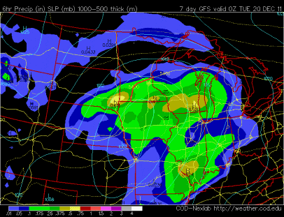
Another storm system we will need to pay attention to comes into play on Monday.  This will be another system that will be teetering on the rain/snow line.  The GFS model is showing the rain/snow line roughly south and east from the northern Twin Cities metro, to just southeast of St. Cloud, and extending south along Minnesota State Highway 15.
storm12202011

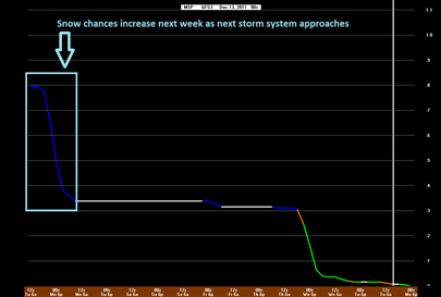
We could see accumulating snow with this system on Monday, but it’s still early to give precise estimates on amounts.

GFSBUFKIT13_00z

What happens late next week and still a mystery, but it will provide one last chance at snow before Christmas if we do not see anything significant before then.  Stay tuned for more on this white Christmas suspense story!

RS

Storm update

The storm event for Wednesday into Thursday is looking more and more like a rain producer.  Some of the models have trended towards shifting a warm front into north central Minnesota, thus allowing precipitation from the approaching low pressure center to fall as rain.  There will not be much snow associated with this, but central Minnesota and the northern parts of the Twin Cities could see some flakes late Wednesday into Thursday morning on the back side of this system as it exits to the east.

The NAM model shows the temperature profile being just above freezing (0°C) at the lowest 6000 feet in the atmosphere at 7 AM on Wednesday to melt any snow in the upper-levels of the atmosphere.

BUFKITNAM12142011

The SREF model also agrees with the precipitation type (p-type) as rain for Wednesday morning.

SREFrain12142011

The European model suggests snow flurries Wednesday morning across the northern and western parts of the greater Twin Cities metro, but as of now, I’m not buying into this solution.  I think we will be too warm to see any snow close to the Twin Cities to start the day.

Euro12142011

It’s looking like this will be a missed opportunity to have a “white” Christmas, but I still believe it’s too soon to declare a “brown” Christmas this year.  I will explain more in my next post.

RS

Sunday, December 11, 2011

Rain midweek; freezing rain?

For snow lovers across the southern half of Minnesota, the storm system for midweek does not look all that promising for snow.  Recent trends are indicating that the southern two-thirds will be in the warm sector, thus any precipitation will fall as rain.  Yes, you heard that right, rain for mid-December!  The red line below from the NAM model indicates the rain/snow line.

rainsnow12142011

Another short-range model, the SREF, shifts the rain/snow line a bit further south, but keeps the southern half of the state in the “rain zone”.

SREFrain12142011

There are some hints that there could be freezing rain at times early Wednesday morning across central Minnesota, and encroaching on the Twin Cities.  This is something that will have to be closely watched in the upcoming days as it could impact the work commute.

SREFzr12142011

There is not a ton of moisture associated with this system.  The southeastern third of Minnesota could see a half to three-quarters inch of rain out between Wednesday morning and Friday morning.  The upper layer of the soil profile is said to be frozen to a few inches in most Minnesota locales, so unfortunately any rain will have difficulty penetrating into the ground to alleviate the drought.

95e12p48iwbg_fill

RS

Saturday, December 10, 2011

A look back at the December 10-12, 2010 snowstorm and blizzard

Between December 10th and 12th, 2010, a paralyzing snow fell over much of southern Minnesota.  By the conclusion of the event, it would have historic impacts - it was the largest snowfall in nearly 20 years for the Twin Cities since the Halloween Blizzard of 1991, the largest snowstorm to affect the Twin Cities in December, and the fifth largest snowfall from any one storm on record in the metro.  The Minnesota Climatology Working Group named it the third biggest weather event of 2010.  It also ranked third on my personal list of top weather events for the year.

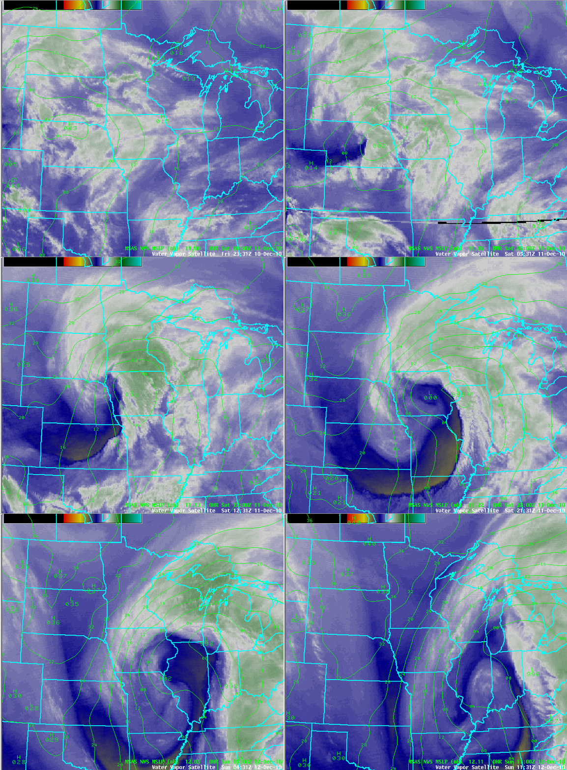
A very potent winter storm developed over South Dakota and Nebraska on Friday, December 10th.  It was an unusual storm in that it was a Pacific type storm system, which are not known to be high snowfall producers due to the limited amount of moisture available.  The moisture transport for this system was along an “atmospheric river”.  Here is an animated loop of the storm system as it moved across the Upper Midwest:

Dec112010_wv_small

Precipitation began as freezing rain, with sleet across far southern Minnesota on the evening of the 10th.  Eventually enough cold air wrapped into the system to cause all precipitation to change over to snow before midnight.  Snow continued into the day on Saturday, December 11th.  Radar loop of the precipitation as it moved through the area during the duration of the event:

Dec112010_radar

The storm system strengthened as it moved into Iowa through the 11th, and brought the highest snow accumulations during the morning and afternoon hours.  The deepened low pressure area created a tight pressure gradient in the atmosphere to generate strong winds and blizzard-like conditions across southern Minnesota, including the southern parts of the Twin Cities metro (Carver, Scott, and Dakota Counties).

Visibilities to one-quarter mile or less was reported at MSP airport during a seven hour span on December 11th. This resulted in the airport being shut down for four hours.  The poor visibilities were captured by a fixed camera I set up at my weather desk in Shakopee.

The storm system then moved east Saturday night, causing the snow to come to an end across southeast Minnesota by the morning of December 12th.  The weight of all the snow collapsed the roof of the Metrodome in Minneapolis during the early morning hours.

The highest concentration of snow occurred across east central and southeast Minnesota. A total of 17.1 inches of snow fell officially in the Twin Cities at Twin Cities International Airport during the 10th (0.8 inch) and 11th (16.3 inches).  Locally, I measured 21.5 inches of snow from the storm on the front sidewalk.  It was a challenging snow to measure with winds from 25 to 40 MPH causing snow drifts.  Here was the view from outside my front door just before 1 PM on the 11th:

029

Our neighbors on the east side of the St. Croix, Eau Claire, Wisconsin, picked up 22 inches of snow in one day, setting a new record. The largest Minnesota snow total was 23 inches recorded in the southeastern city of Winona.  Here are snowfall totals across the state from the National Weather Service in Chanhassen:

Here is a closer look at snow amounts in the Twin Cities, and reports from the seven-county area listed by inches, city, and county:

metrosnow

  • 21.0, OAKDALE, WASHINGTON
  • 20.0, MAPLEWOOD, RAMSEY
  • 18.0, (3 SSW) BURNSVILLE, DAKOTA
  • 18.0, (2 W) PRIOR LAKE, SCOTT
  • 17.5, (3 NW) MINNEAPOLIS, HENNEPIN
  • 17.4, LAKEVILLE, DAKOTA
  • 17.2, WOODBURY, WASHINGTON
  • 17.2, (1 W) CARVER, CARVER
  • 17.1, MINNEAPOLIS, HENNEPIN (MSP AIRPORT)
  • 16.5, SAVAGE, SCOTT
  • 16.3, HASTINGS, DAKOTA
  • 16.1, BLOOMINGTON, HENNEPIN
  • 15.5, CHANHASSEN, CARVER (NWS OFFICE)
  • 15.2, ST LOUIS PARK, HENNEPIN
  • 14.7, WACONIA, CARVER
  • 14.5, (3 SSW) WHITE BEAR LAKE, RAMSEY
  • 13.5, (1 ESE) CHASKA, CARVER
  • 13.0, STILLWATER, WASHINGTON
  • 11.5, ANDOVER, ANOKA
  • 10.8, CHAMPLIN, HENNEPIN

This was a memorable storm for several reasons.  It may also be considered this generation’s 1991 Halloween Blizzard for those who may not have been old enough to recall that event, or were not living in the area.

Additional information on this event:

RS