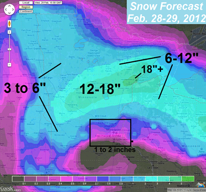
Recent trends of the forecast weather models have shifted the storm track further north for Tuesday and , bringing the low pressure center into southwest Minnesota by Wednesday morning.
This northerly shift draw more warm air into the weather system to cause precipitation to fall mostly as rain during the duration of the storm.
Temperatures will climb well into the 30s in the Twin Cities, with some 40 degree readings expected across southeastern Minnesota near Rochester.
Precipitation will fall as a mix of rain and snow as temperatures hover around freezing Tuesday morning.
The mix will transition to all rain by Tuesday afternoon across the Twin Cities with snow falling from a line north of Isanti to St. Cloud. Rain will continue across the metro and begin the transition back to snow Wednesday morning by 9 AM or so, where we may pick up an inch or two of snow when it’s all said and done. Some parts of southeastern Minnesota may not see much precipitation of any kind as the “dry slot”, which I’ve mentioned for the last several days, works into the southeastern quadrant of the low pressure area. The dry slot is like a shut off valve for moisture. It can reduce the amount of available moisture to create snow quite impressively.
Central Minnesota will see the bulk of the snow from this system as it will remain cold enough for snow across this area. Given then ample amount of liquid precipitation this system has to work with, amounts in excess of a foot of snow would not be shocking. The bullseye for this heavy snow would be from Alexandria to Brainerd to the Duluth area. Lake effect snows may push snow totals around Brainerd over a foot and a half! Some places across the Arrowhead saw a foot of snow on Sunday, so residents will be digging out from a second round!
It’s finally starting to look like winter across the northern half of the state. It only took us until the end of February to make it a reality.
RS


No comments:
Post a Comment