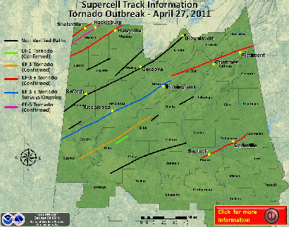
April 2011 is now in the books and what an active severe weather month it was across the southern and eastern part of the United States. The month brought the second largest tornado outbreak in history with 263 preliminary tornado reports on April 27th (numbers as of May 1st). All the red dots below represent tornado reports from that day. At least 344 people have died, according to NOAA estimates, from this outbreak making this the deadliest single day for tornadoes since the March 18, 1925, tornado outbreak that resulted in 747 fatalities across 7 states. Even with advanced technology and warning systems in place today, it’s a matter of fate surviving through an EF-4 or EF-5 tornado.
Tornadoes were the common theme in April with major metropolitan areas being affected. Raleigh, North Carolina took a direct hit by an EF-1 tornado on April 16th. North Carolina saw as many as 30 tornadoes that day, and pending the final count, could be the largest single day tornado outbreak in the state’s history. Six days later, on Good Friday, a tornado ripped through the northern section of the St. Louis, Missouri metro with EF-4 damage. Lambert-St. Louis International Airport took a hit. Extensive damage was done to one of the concourses, and it was believed it would take up to two months to completely repair. The super outbreak on April 27th saw complete devastation across much of Mississippi and Alabama. Nearly every supercell spawned that day was rotating, and had a tornado warning on it. A long track tornado, directly impacted the city of Tuscaloosa, Alabama and continued on a path brushing the northern Birmingham, Alabama metro area. Damage surveys are still taking place, but the preliminary rating of the Tuscaloosa to Birmingham tornado is EF-3. Including the numbers from the worst outbreak in modern history, the United States has now seen a preliminary count of over 1,000 tornadoes(!) through April this year. That is usually what the country averages in a year! Unreal.
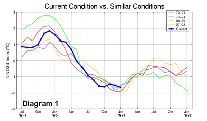
Closer to home, our cool and wet weather pattern has prevented these horrific severe weather events from occurring here as a result of La Nina. That’s the trade-off we get, and it should be safe to say that I think most would find our weather to be the lesser of the two evils. The effects of La Nina should be gone by June, as indicated by the model predictions below.
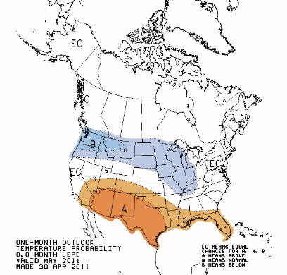
Until then, we should expect May to have a similar climate pattern to April as we head into another month of the weakening La Nina. According to the Climate Prediction Center, forecasters believe that will be the case for May with chances of below normal monthly temps for much of the northern tier of the country with above average precipitation chances once again. Free lawn waterings for everyone! Looking ahead the next couple weeks, I think it’s still too early to get excited about 70-degree readings yet. There has been some inconstancies with the model data around the middle of May.
What does this all mean once the weather pattern shifts in June? Well, it’s not truly possible to correlate the severe weather activity across the south with what we’ll experience this year. However, we can look at global weather patterns, and try to make a forecast based on conditions experienced in prior years with similar variables. Looking at climate conditions this summer from the strength of this past La Nina, it is comparable to 1971, 1974, 1999, and 2008.
When we have a similar strength La Nina, the National Weather Service in Chanhassen believes that there are equal chances of an active or non-active tornado season. Looking at the the most recent La Nina influenced summer, the 2008 season in Minnesota was most notable for the EF-3 tornado that struck Hugo, Minnesota, resulting in one fatality. 2008 did turn out to be an above average year for tornadoes with a final tally of 43. Between 1950 and 2009, the state averages nearly 26 tornadoes a year. I don’t expect May to be real active for severe weather, but beyond that, it’s anyone’s guess. Last year, we saw a very active June, and the recent trend as been a late start to the tornado season across Minnesota. It will be interesting to see how this all unfolds as we transition from spring(?) to summer. Definitely will be worth monitoring.
RS


we could say that April wasnt just for Aprils fools day but for tornadoes also... it was horrible indeed fearsome... indeed when mother natures strikes it brings wrath
ReplyDeleteStorm Repairs minneapolis