A stormy weather pattern is on tap this week after we have enjoyed sunshine and 70-degree weather the past couple days. It was finally nice to enjoy being outside and opening up windows in the house to get some fresh air flowing. Very enjoyable!
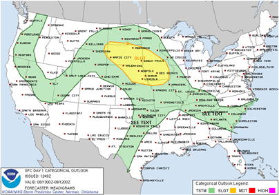
With the return of the warmth, we are a looking at thunderstorm chances increasing through Wednesday. The Storm Predication Center has indicated a slight risk of severe thunderstorms over southwest Minnesota today, roughly southwest of the Minnesota River. The setup for severe weather today is marginal- storms will be isolated and I’m not expecting any widespread outbreaks.
The severe weather chances are looking the greatest in southern Minnesota, approaching the Twin Cities metro, on Tuesday, after the dinner hour, *IF* storms are able to overcome a cap that is forecasted to be in place for much of the day. There has been a bit of weather model unpredictability lately as the models are dealing with the transition from the cold/snow to warm/thunderstorm season. Convective Available Potential Energy (CAPE) values over 2000 J/kg are definitely supportive of severe weather and Energy Helicity Index (EHI) is supportive of supercells with tornadoes.
I will continue to monitor the stormy situation and provide updates as warranted. A new feature I’ve added to the blog on the main page is a 5-day severe weather outlook to provide a quick glance as to what active weather is possible during the period. It is more or less a blog within a blog to provide critical information for upcoming dangerous weather situations. Feel free to provide feedback on this feature if you find it helpful, or there are tweaks you would like to see.
Happy Mother’s Day!
RS


No comments:
Post a Comment