Monday, May 30, 2011

Memorial Day Forecast

I’ve been watching Memorial Day for the last several days to understand what kind of severe weather outbreak we may have across the Midwest.  My analysis of the most active weather today is an agreement with the Storm Prediction Center.  The moderate risk area in red across eastern South Dakota into far western Minnesota will be the hot zone today for all modes of weather – tornadoes, large hail, and damage winds.  This weather is an association with a cold front that will be moving in from the Dakotas through Minnesota during the overnight hours on Tuesday.

spc053011

Looking at the four major severe weather parameters from Twister Data – instability, shear, lift, and moisture, it appears everything is in place for an active day.  There is one key area which is keeping this day from being a potentially explosive outbreak that I will touch on later.

Instability – check.  CAPE values are very high signaling extreme instability in the atmosphere over the eastern Dakotas and Minnesota.

RUC_255_2011053014_F10_CAPE_SURFACE

Shear – check.  The strongest levels of shear will be found over Nebraska, however, the entire area will be conducive for tornado development by this evening.

RUC_255_2011053014_F10_EHI1_SURFACE 

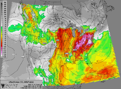
Lift – check.  The cold front will surface as the lifting mechanism for storms to fire across Nebraska and up through northeastern South Dakota

RUC_255_2011053014_F11_LFTX_SURFACE

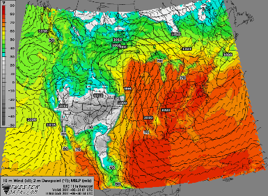
Moisture – check.  Out ahead of the cold front and south of a northward lifting warm front, dewpoints will scream well into the 60s with some 70-degree readings possible.

RUC_255_2011053014_F11_DPTF_2_M_ABOVE_GROUND

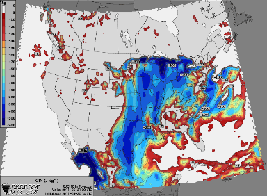
So what’s the one major variable that’s holding this back from being a huge outbreak? It’s the cap – warm air aloft.  This is one of the stronger caps I’ve seen all year so far.  It’s expected to hold throughout much of the day, but appears it will weaken enough for storms to develop across Nebraska, South Dakota, and far western Minnesota.  This cap will keep the storms from tracking far quickly and some of the models show the storms weakening as they move across Minnesota during the late night hours towards the Twin Cities.  With the strength of the cap, I can buy into this, and it’s been a trend with the models during the last couple days.

RUC_255_2011053014_F10_CIN_SURFACE

Here are a couple models “futurecasing” the precipitation later today.

The HRRR places storm initiation across central Nebraska this evening.  Supercells are forecasted to develop during this time period.

1ref_sfc_f11

As we move into the late night, the supercells are expected to transition into a squall line as they march through Minnesota.  By 10 PM, the line is approaching the Alexandria and Willmar areas.

1ref_sfc_f15

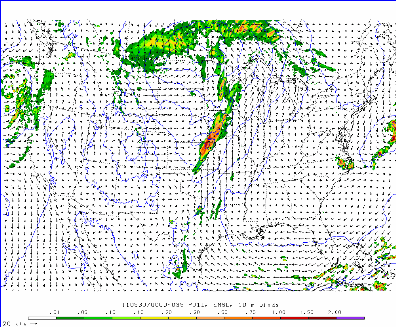
The high resolution WRF model shows more of a line of storms forming generally in the same area as the HRRR.

today_1h_f26

During the overnight hours, the line of storms dissipates as it marches towards the Twin Cities metro as it as trouble working against the cap in place.  We may see a few stronger storms out of this, but not expecting widespread severe weather during this time frame.

today_1h_f35

So this is what I’m forecasting today.  For people across the western portion of the state, you’ll want to pay attention to the skies closely and move indoors quickly if it turns threatening.  Have a great Memorial Day!

RS

Heavier storms this morning

Some stronger storms are making their way through the Twin Cities this morning.  Nothing severe, but Minneapolis-St. Paul and east suburbs may see some small hail out of this.  More storms are beginning to form to the southwest and will also pose a small hail threat.

Capture

RS

Sunday, May 29, 2011

05.22.11 Minneapolis, MN

It was another unusual day for tornadoes. Didn't feel real conducive for severe weather with the morning convection and clouds lingering around.  A strong low pressure system was forecasted to track from the Dakotas across the Twin Cities metro area into Wisconsin.  I illustrated the position of the low pressure center, valid at 2:43 PM Sunday.

2011052219_metars_dlh

I was local this day as I was visiting my parents in Eden Prairie.  A linear segment with embeded individual cells were moving into the southwest side of the metro by 1 PM, which prompted the first metro warning of the day for severe thunderstorms at 12:53 PM.

MPX_N0R_1105221800_912x684_none__173

Things didn’t really start to get interesting until 2 PM, when I was tracking an area of rotation on the velocity radar scan (watching winds towards and away from the radar site in Chanhassen) approaching the Eden Prairie area.  Did some “porch” chasing after 2 PM as I watched the rotation pass about a half mile to the east along near Highway 169 in Eden Prairie.  There were just a bunch of low based clouds, but nothing real interesting at that point.  Here is radar imagery put together by the National Weather Service in Chanhassen beginning at 2 PM:

MinneapolisTornado

The National Weather Service also released an image of the areas of stronger rotation as the storms tracked through the metro:

230961_212267825473354_200752513291552_685539_1028112_n

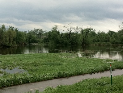
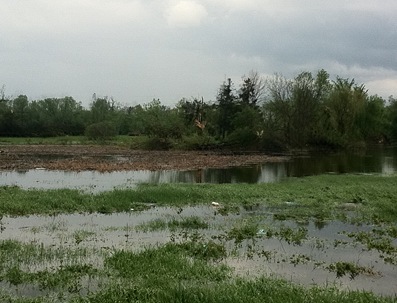
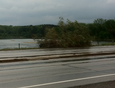
Heard a tornado warning issued at 2:10 PM as the storms tracked north and decided to go after them since it appeared business was about to pick up. Chased with nothing more than a cell phone with radar and ham radio due to the unexpected nature of the severe weather setup.  Pretty much was playing catch-up with the storm from the beginning, so I ending up being more of a damage spotter than storm chaser this day.  In the car, I was flipping between WCCO and MPR on the car radio to hear of any damage reports.  Heard reports coming in of activity/damage in the St. Louis Park area, so I took Highway 100 up towards the St. Louis Park/Minneapolis area where I began to see debris in the road at Highway 100 and Interstate 394.  There were pieces of brown insulation that I later learned were from the Nestle plant nearby. From Highway 100, I took the Highway 55 east exit and about 1.25 miles down the road is where I saw what appeared to be the tornado path as trees were snapped at Theo Wirth Park near the Golden Valley/Minneapolis border.  I stopped the car along Highway 55 to check out the damage and also reported to the NWS that something went through here, so they would be aware of it for when they did their survey. Took these photos at 2:53 PM from Highway 55 in Wirth Park on my cell phone and lack zoom, so I apologize for the quality. They won't win any awards.  I was standing in what I thought was the tornado path track.  This was my first chase ever where I’ve seen damage first-hand from an apparent tornado.

Large trees snapped in the distance:

205206

Downed tree limbs blocking the Highway 55 shoulder and twisted street signs near Wirth Lake:

207208209

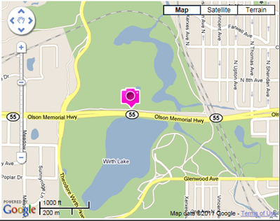
Since I used my phone, I was able to geotag the photos and this is where they were taken. Based on the damage pattern with fallen trees in different directions, it looked possible that a tornado went across Wirth Lake and the park.

gpswirthpark

The National Weather Service performed a damage survey and by Tuesday had concluded that an EF-1 tornado tracked from St. Louis Park to Blaine, including the Wirth Park area. 

Google%20Earth%20Image

This tornado was one in a family of small tornadoes that touched down this day around the Twin Cities metro. Had we received more sunshine and daytime heating, I feel that this situation could have been A LOT worse! It will take some time for Minneapolis to recover, but it just goes to show you how even an EF-1 tornado can wreck havoc on a metropolis!

Total reports: 1

“12 TO 18 INCH TREE LIMBS DOWN IN THEO. WIRTH
PARK...SPOTTER SAYS POSIBLE TORNADO”

RS

05.28.11 Southern Twin Cities MN

It was another day of crazy weather across the southern Twin Cities metro as severe storms fired very unexpectedly (in many people’s minds).  Going into Saturday, it appeared if there was going to be any severe weather, it was going to be north of the metro in eastern Minnesota.  I’m not going to make any excuses.  I didn’t see this coming as I was expecting to spend a pleasant afternoon over at Canterbury Park in Shakopee.  Fortunately,  the storms were headed for Scott County and were local, so I was already in a somewhat decent spot to get on these storms.  It appeared that the storms were going to move in a northeasterly direction and clip Shakopee as well as the heart of the Twin Cities, but then the supercell decided to make a more easterly progression as it came into Scott County.  Here is the radar base reflectivity of the supercell as it tracked through Sibley and Scott Counties:

MPX_N0R_1105282057_800x600_none__0865_an

As the storms approached, I could see mammatus clouds build in from the southwest over Canterbury, which is a signal that active weather is in the area.  After hearing about a tornado warning issued for Sibley and Carver Counties at 2:39 PM, I left Canterbury Park to chase.  I didn’t want to have my car just sit in the parking lot and get hailed on either had the cell continued to move northeast.  I got my anemometer setup and hit the road towards Prior Lake.  Saw just a ton of heavy rain out of this and some pea size hail.  I wanted to get further south and east, so I took County Road 21 from Highway 13 to Interstate 35 to head south.

I got off at the Lonsdale exit on I-35 and headed a little bit west so I could get a better look at the tail end of the supercell.  The cell was going to cross north of me, so I knew I was going to be safe even if a tornado was going to touch down.  At 3:58 PM, I shot the only  photo of the day of this lowering of the cloud base as I looked to my northwest, which placed the storm north of Lonsdale.

016

Here is the NEXRAD radar image from 3:57 PM.  I’m just to the southeast of the little notch on the southern end of the supercell in Little Chicago township.

radar400PM

gpsmark052811

Because I used my cell phone for taking the photo (because I was caught off-guard, I had no equipment other than a ham radio and cell phone with me), I was able to geotag my location of where I took the photo.  It’s amazing what you can do with technology nowadays, and I find geotagging to be important for severe weather reporting so I’m able to get a better sense of where I am when I shoot photos.  I really like having this ability for recalling information.

I had to stop for gas before continuing and the delay caused me to fall behind the storm as it marched east and I wasn’t able to catch up to the storm again until I got to Red Wing.  From Red Wing, I decided to call it a day since it’s difficult to chase in the bluffs along the Mississippi River due to the poor visibility, as well as the limited road network.

Here are the storm reports from around southern Minnesota for the day.  The majority of the reports were for hail, but a brief spin-up tornado was reported at 2:38 PM just west of Gaylord with funnel cloud reports in Henderson and New Prague.

reports

It was quite an active day and surprise, which seems to be following the theme of this year.  I’m thinking this will be a very active year as we head towards June for the Upper Midwest.  As I mentioned in a previous post, it’s important for the public to to take safety precautions and have safeguards in place.  You never know when disaster might affect you!

RS

Wednesday, May 25, 2011

Week in Review: Tornadoes across the Midwest

It was quite the active weekend across the Twin Cities metro area for storms.  From a forecasting standpoint, it was very frustrating trying to predict when and where storms were going to initiate because off morning rains and cloud cover, we never got the heating that is usually required to get the instability and violent storms.  This was definitely not a textbook case for favorable severe weather conditions.  Saturday saw enough afternoon heating to create storms that did put down a brief tornado in the city of Medina and Sunday had enough wind energy to keep storms turning, which produced a 14-1/4 mile EF-1 tornado across St. Louis Park, Golden Valley, northern Minneapolis, Fridley, and Blaine.  The Minneapolis tornado ended up being the weakest of the weekend tornadoes if you can believe that.  The storm system also produced tornadoes in Midwestern cities such as La Crosse, Wisconsin (EF-2) and the hardest hit area, Joplin, Missouri, which took the brunt of an EF-5 tornado.  The tornado has killed at least 125 people as of this writing.

TWC Severe Weather Expert, Dr. Greg Forbes (Find him on Facebook) now says the Joplin, Mo. tornado is the deadliest single U.S. tornado in 64 years, since 181 were killed in Woodward, Okla. on Apr. 9, 1947.

Top 10 deadliest tornadoes

  1. Mar. 18, 1925 (Tri-State Tornado): 695
  2. May 6, 1840 (Natchez, Miss.): 317
  3. May 27, 1896 (St. Louis, Mo.): 255
  4. Apr. 5, 1936 (Tupelo, Miss.): 216
  5. Apr. 6, 1936 (Gainesville, Ga.): 203
  6. Apr. 9, 1947 (Woodward, Okla.): 181
  7. Apr. 24, 1908 (Amite, La., Purvis, Miss.): 143
  8. May 22, 2011 (Joplin, Mo.): 125
  9. Jun. 12, 1899 (New Richmond, Wisc.): 117
  10. Jun. 8, 1953 (Flint, Mich.): 115

On Tuesday, more deadly tornadoes spawned across the south in Oklahoma, Kansas, and Arkansas. These storms killed 13 people and brought the death toll for 2011 at more than 500 with 501 fatalities reported.  The hardest hit area from these storms was the Oklahoma City metro, where a family of at least EF-3 tornadoes touched down.

Wednesday brought the second consecutive day of severe weather to the Midwest states with several tornadoes across Missouri – including the Kansas City and St. Louis metro areas.

today

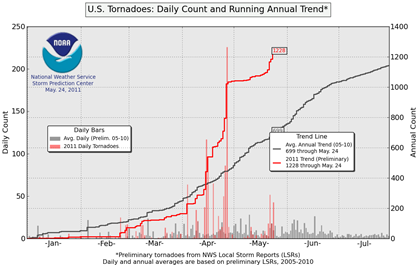
As of May 24th, there have been over 1,200 this year.  The country typically averages around a 1,000 per year and we are not even into the summer months yet!

ptorngraph-big

What’s the cause of all these particularly violent storms this year?  La Nina is said to blame, but a new study shows that the affects of the surface sea temperature phenomenon on tornado activity is inconclusive:

What is the current understanding of La Niña effects on US tornado occurrences? There are suggestions that winter (January-March) tornado counts may change their preferred geographical location depending on the phase of the El Niño/Southern Oscillation (ENSO). However, that study's analysis covering 1950-2003 found that neither the frequency of tornado days nor of violent tornado days (days with 5 or more F2+ tornadoes) is affected systematically by the phase ENSO for the US as a whole. A separate investigation that used data for a shorter period of 1950-1992, but covering all seasons, argued that La Niña events increase tornadic activity in the Ohio River Valley and the Deep South during spring, and that La Niña facilitates large tornadic outbreaks and is associated with more destructive storms.

It’s been a rather unbelievable year so far with an unprecedented amount of death and destruction, particularly to metro areas.  Hopefully this year will break the myth that metropolitan tornadoes can’t happen.  There is not such thing as a shield.  Tornadoes touchdown wherever the conditions come together, whether it is the middle of nowhere or a downtown district.  We still have more open land than cities across the United States, so that’s why you hear more reports (or go unreported) of tornadoes in rural areas.  That might also explain the spike in tornadoes over the last 50-60 years.  Urbanization and the advancement of technology in the information age makes it difficult for any tornado to go undetected anymore.

As we head into June, I recommend checking your insurance policy of your dwelling and make sure you’re adequately covered - that includes renters.  If you have not purchased a NOAA weather radio this year, I HIGHLY, HIGHLY recommend it.  It’s the cheapest form of life insurance you can buy for yourself and family.  Outdoor sirens were meant to be heard OUTDOORS, and as we saw in Washington County over the weekend, they can be prone to failure.  Sign up for free cell phone alerts from Cell Warn (texting rates apply).  From my observations with the Minneapolis tornado, there were far too many people that did not have the early warning.  Don’t let that happen to you!

RS

Sunday, May 22, 2011

Good chances of severe weather for the area today

Severe weather chances will return for Sunday as a strong area of low pressure moves from the Dakotas across Minnesota.  The upper-level winds out ahead of this system are very strong, which will cause quite a bit of turning in the atmosphere.  Enough for supercells with the possibility of tornadoes.

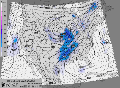
RUC_255_2011052213_F08_WSPD_850_MB

Here is a look at the difference in wind direction from the surface up to approximately 18,000 feet.  Notice that winds as you head towards Wisconsin are nearly 90 degrees, which is ideal for rotation within the supercells.

RUC_255_2011052213_F08_WSPD_10_M_ABOVE_GROUND_500_MB

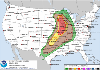
Here is the Storm Prediction Center outlook for the tornado risk today. There is a high potential for tornadoes across much of the Midwest.  For Minnesota, the greatest tornado threat will lay over the southeastern Minnesota, roughly east of a Rochester north-south line. However, much of state has at least an isolated chance of a tornado.

torprob

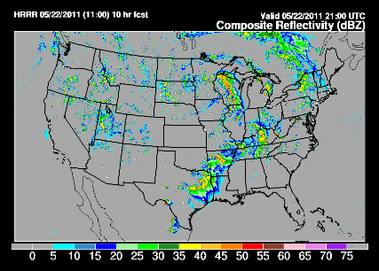
Looking ahead for later today around 4 PM using my two favorite “futurecasting” sources for determining where storms may develop, there seems to be a bit of disagreement.  The first model places storm development near Rochester and the other initiates storms north of the Twin Cities.  I’m tending to favor the first model because it’s in closer to the proximity of the upper-level winds and also frontal boundaries.  Concerned with the Rochester area today and points southeastward for having a rough day.

today_1h_f21

cref_sfc_f10You’ll want to keep an eye to the sky and follow watch and warning information on the right side of this blog today.

RS

Saturday, May 21, 2011

Strong storms to the west of the metro

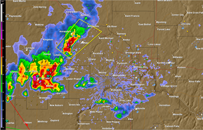
Some heavier storms are moving in towards the west metro at the 5 PM hour.  There is a severe thunderstorm warning for Wright Co. until 5:45 PM.  Hail up to one inch is possible with these storms.  Not hearing reports of strong winds with these storms.

Capture

RS

Rain totals from Friday

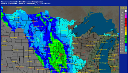
Here is a look at precipitation totals from yesterday since 7 AM Saturday morning.  Looking across the state, most areas have picked up anywhere from .25 to 1.25 inches of rain over a 24-hour period.

Capture

Rainfall totals across the metro average around half an inch with over an inch reported at the St. Paul airport.

metroprecip

We’ll definitely add onto these totals today with on and off rain expected throughout the day.  Hopefully we will see some peaks of the sun, but our chances are not looking too good right now.

RS

Thursday, May 19, 2011

Weekend outlook – Here comes the rain

Our “Omega High” blocking pattern that kept the state dry and brought us very pleasant temperatures for much of the week is in the process of breaking down.  A low pressure area will move into a position near the South Dakota/Nebraska border and stream moisture in from the Gulf of Mexico.  You will feel the humidity this weekend as dewpoints make their return above the comfortable level and into the 60-degree range.  This tropical moisture will bring with it rain for a good portion of the weekend with some heavier rain amounts, especially across the southwest and western part of the state.

The map below illustrates the amount of rainfall in inches possible Thursday night through Sunday night.  We are looking at around 1.25 to 1.50-inches of rain out of this system, with amounts close to 2 inches in southwest Minnesota in closer proximity to the low pressure center.

d13_fill

I have been monitoring the dynamics for severe weather with this system for the last couple days and the parameters appear weak for any organized severe weather threat.  The worst of the weather will stay south of the Minnesota border into Iowa.

Rain will begin to fall Friday night and last into Saturday night, where we will get a break until Sunday afternoon.  We had a good stretch of nice weather, and while it’s disappointing to see the rain, especially on a weekend, we couldn’t expect our fortunes to last forever.  Mother Nature always finds a way to balance things out.  This is why I’m not on the global warning bandwagon yet, but that’s another topic for another time.  Have indoor plans ready to go for the weekend.  The track at Canterbury Park will be a sloppy one, and will play a role in which horses are favored.

Enjoy what you can of the weekend!

-RS

Sunday, May 15, 2011

Return of sunshine and 70-degree temperatures

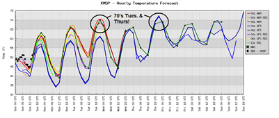
After a cool, wet, and stormy week across much of the state, this week is fairing much better.  We’ll see the return of sunshine as high pressure settles into the area for much of the week.  With the sun, we’ll see a good chance of reaching 70-degrees on both Tuesday and Thursday.  Finally a chance to get back outside!  Some frost may be possible in the outlying suburbs of the Twin Cities metro into Western Wisconsin Monday morning, so it may be a good idea to cover up and delicate plants as a precaution.

untitled

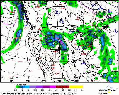
The next chance of rain moves into the area Thursday night as a low pressure system approaches from the southwest.  Precipitation amounts appear to be light, however this rain could linger into the weekend.  Any outdoor plans my need a “Plan B” at this point.  The graphic below is valid at 7 PM Thursday.

CONUS_GFS_1000-500_SLPPRPTHK_120HR

Today through Wednesday will be very nice.  Get out and enjoy!

RS

Friday, May 13, 2011

05.10.11 Twin Cities MN

The Twin Cities metro area was affected by severe weather after a very unseasonably warm and record setting day for humidity readings.  This helped fuel the atmosphere for thunderstorm development.  A tornado watch was issued just before 6 PM.  I was a little surprised the Storm Prediction Center went with a tornado watch since I didn’t think the wind shear parameters were all that great near the metro.  Because it wasn’t looking like a huge outbreak, I decided not to go through the trouble of setting up a live chase stream.  In fact, I decided to chase light on the gear.  Along with my DSLR and Handycam cameras, I used a cell phone for radar, and as my primary means for submitting storm reports.
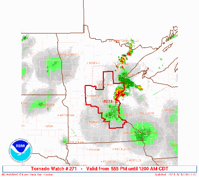
ww0271_radar_big

I started my chasing journey around 6:30 PM headed south on Highway 13 to catch up with some cells developing near New Prague in Scott County.  The storms were just beginning and were not really showing anything interesting other than some rain.  Headed east on Highway 19 towards Interstate 35 to head back north.  As I was traveling north on I-35 near Lakeville, there was a severe thunderstorm warning issued for the cell in Scott County for possible quarter size hail at 7:25 PM. Making my way through Scott County, all was quiet. Just some heavy rains and some small hail mixed in.  The storm was still trying to get organized from what I could see on radar and I was a little surprised to see a SVR warning on this cell.  It was one of the few SVR warnings issued by the National Weather Service (NWS) in Chanhassen that did not verify that evening – storm reports did not meet severe criteria for that particular warning.  As the cell traveled north through Shakopee into extreme eastern Carver County and western Hennepin County, the cell merged with another cell near Deephaven and traveled east through the northwest side of Eden Prairie.

MPX_N0R_1105110200_640x480_none__0865_an

In was in Eden Prairie where things began to get interesting.  This is where the larger hailstones started to fall.  Hail greater than one inch poured from the sky and laid on the road.  Vehicles stopped underneath overpasses to get out of the hail.  I stopped at a gas station off of Highway 5 and Mitchell Road to get a better look at the storms.  Here is a photo from Eden Prairie at 8:16 PM looking northeast shortly after the storm went tornado warned at 8:10 PM.  There were some low hanging clouds in the distance, but nothing that appeared to be a funnel cloud or tornado.  Saw one inch hail at this location and reported it to the National Weather Service via eSpotter.

001

I followed this tornado warned storm through Eden Prairie into Bloomington and eventually St. Louis Park on Interstate 494 and Highway 100.  Traveling north on Highway 100, I saw a funnel to the northwest of my location shortly after 8:30 PM as I was on the off-ramp to Excelsior Blvd.  At 8:30 PM, a spotter reported a funnel cloud near Highway 169 and Excelsior Blvd and I believe this was the same funnel I was looking at.  Unfortunately, I was stuck at a long stop light trying to get onto a side street where I could stop and take photos.  The joy of storm chasing in the Cities!  By the time I got stopped and got the camera ready, the funnel was out of my view.  Here are some photos of the tail end of an apparent wall cloud over St. Louis Park from 8:32 PM where I saw the funnel minutes earlier.  If something was going to drop from the clouds, it was going to be at this spot.  In the foreground is Highway 100.  The storm also produced some of the most beautiful mammatus clouds I’ve ever seen, which is seen here on the far right side of the first photo.


005
007

I continued to follow the storm north on Highway 100 to Highway 55 east into Minneapolis towards Target Field, home of the Minnesota Twins.  The Twins were hosting the Detroit Tigers and this was setting up to be a dangerous situation with 40,000 fans inside the ballpark.  I was behind the storm and could not see any more evidence of a severe storm, but large hail, nearly half dollar size, was witnessed at Target Field around 8:35 PM.  Once I reached Target Field, I decided to call it a day and head home as the storm cell began to weaken as it moved northeastward and I was losing daylight.

I did not notice a lot of wind associated with the storm cell that tracked over Minneapolis from Eden Prairie.  This storms were inflow dominate and produced towering vertical cumulonimbus clouds.  The strength of the updraft is tied to the size of the hail.  The longer the updraft keeps the hail floating aloft, the larger the hail gets before the updraft can no longer support the weight of the hail and falls towards the ground.  The NWS put together hail tracks from the storms that moved over the Twin Cities metro based on radar reflectivity.  There are two distinct storm tracks.  One from Chanhassen to downtown Minneapolis, and a second from near St. Michael over to Isanti.  The St. Michael storm did produce a brief tornado three miles long from Hanover to St. Michael, rated an EF-1 with top winds at 90 MPH.  One neighborhood suffered damage west of downtown St. Michael.

11may10_mesh

Additional text listing of storm reports from the day can be found here.  Here is a graphical depiction of storm reports.  As you can see, the hail reports match the estimated hail track from NWS radar.

stormreports051011

Here is a GPS summary of my storm chasing journey for the day.  Starting from my home in Shakopee and finishing in Minneapolis.  It was a nice local chase that materialized based on my forecast of storm development around 7 PM for the Twin Cities.  Being close to home made it easier to stomach the price of gas versus my previous chase in Wisconsin a month ago, which was a disappointing bust.
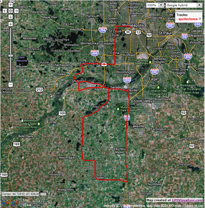
chasetrip

We had our first severe weather outbreak across the Twin Cities metro and surrounding areas, our first tornado watch, and our first tornado report for the year.  I’m just grateful the storms were not worse over Minneapolis. That could have been a terrible situation with all the people at Target Field to watch the baseball game.  Had the storm that tracked from across the southwest metro been tornadic, downtown Minneapolis as well as Target Field would have taken a direct hit.  That was the biggest positive that came out of this for me.

Total Reports: 1 (1” hail in Eden Prairie)

RS
Tuesday, May 10, 2011

Severe weather threat for Tuesday

Tuesday is looking to be an active day for the southern half of Minnesota later on the day Tuesday.  Still expecting an outbreak of severe weather, a 2 and 10 chance for any location south of Interstate 94 where the CAPE values will be the highest.  There will be plenty of “juice” for storms to work with.  The gasoline will be in place with plenty of instability as a result of temperatures  now there needs to be the spark.  Not expecting a widespread outbreak as there will be pockets of instability where there is a weak cap.

CAPE values at the surface approaching 5000 J/kg south of Interstate 94 illustrated below at 7 PM Tuesday.  There is where the storms will initiate if able to over the cap.  The cap (warm air at all layers of the atmosphere preventing cloud growth) will be the contingency with the severe weather setup on Tuesday.  It will be all or nothing as temperatures approach 80 degrees.  I expect us to be in the sun much of the day before storms roll in during the evening/overnight hours.  Any time after 4 PM is when storms may fire.

NAM_221_2011051000_F24_CAPE_SURFACE

The GFS and NAM forecast models below at 7 PM are in agreement that western Minnesota, from Worthington northwards to Fergus Falls, will have the weakest cap (red and white shading – values closer to zero indicates a weaker cap) near the intersection of a warm and cold front on the Minnesota/Dakotas border.  Based on this observation, there will be a greater likelihood of severe weather over the western half of Minnesota with the Twin Cities seeing storms towards midnight.

GFS_3_2011051000_F24_CIN_SURFACE

NAM_221_2011051000_F24_CIN_SURFACE

You’ll want to stay tuned to this blog and local media for possible watches and warnings throughout the day on Tuesday, especially if you have outdoor interests.  With this unfamiliar warm stretch of weather this spring, many people will be out enjoying themselves not realizing the possibilities of strong to severe thunderstorms with all this heat and humidity.  Like a local television weatherperson around here says, you’ll want to stay sky aware!

RS