The heat wave concluded Friday night as a cold frontal boundary pushed from north to south across the southern half of Minnesota, and triggered a few rain showers and thunderstorms. The hot weather went out with a bang as the high temperature in the Twin Cities reached 102 degrees. It was also the first time since 1988 that one month has seen at least two days with temperatures at 100 degrees or above.
The stretch of eight days from June 29 to July 6 with high temperatures at 90 degrees or above has happened on five other occasions in the Twin Cities. The average high temperature during this period was 96.4 degrees, and the average temperature was 84.5 degrees. This would make it the 4th warmest heat wave ever based on mean temperature!
| Date | High Temp | Record Temp | Year |
| 6/29/12 | 90 | 102 | 1931 |
| 6/30/12 | 92 | 100 | 1931 |
| 7/1/12 | 94 | 100 | 1883 |
| 7/2/12 | 99* | 96 | 1911 |
| 7/3/12 | 97 | 100 | 1949 1990 |
| 7/4/12 | 101* | 100 | 1949 |
| 7/5/12 | 96 | 100 | 1982 |
| 7/6/12 | 102 | 104 | 1936 |
The sagging frontal boundary was very visible on radar Friday night. Thunderstorms developed along the leading edge on this boundary, but had a hard time surviving.
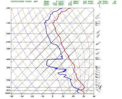
Why did the storms die off so quickly? There was a capping inversion in the atmosphere. What that means is there was a layer of warm (stable) air stacked on top of a colder layer. Cloud formation from the lower layer is "capped" by the inversion layer. Convection requires warm air rising into cold air.
Shown below is a temperature profile at the National Weather Service in Chanhassen at 7 pm Friday. While temperatures (red line) initially decrease with height from the surface, temperatures increased with height from 925 millibars (~2500 feet above sea level) to 850 millibars (~4600 feet above sea level). The limited how much storms could grow, even when there is plenty of energy for them to work with.
Dr. Greg Forbes from The Weather Channel briefly explains in the video clip below how the cap prevents thunderstorms from happening:
RS


THANKS for the information! I appreciate knowing what makes the weather happen, and you make it so easily understood. Thanks for all the hard work on your part ... I feel much more informed since I subscribed to your site!
ReplyDeleteI appreciate the comment, Olk Folks! That means a lot to me! Glad to hear you find this blog of some use. My goal is to make weather easy to understand for regular people.
Delete-Ryan