A warm front, or is this instance, a “hot” front will move to the International border by this evening. This front will be the focus for thunderstorms, some of which will be severe across the north. To the south of the front, very warm air will dominate the state today.
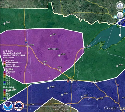
The greatest area of concern for severe thunderstorms is north of a St. Cloud line, but the focus for storm development will be near the warm and cold front intersection.
The Storm Prediction Center has indicated hail as the greatest threat today, with the purple area below as the area at risk.
Unlike yesterday’s setup, a tornado threat does exist today as an area of low pressure moves into the northwest portion of the state. Areas northwest from Bemidji may see an isolated risk of a tornado during the early stages of severe weather.
The high-resolution WRF model at 7 pm below depicts a bow echo moving through the Northland tonight, with a secondary bowing mesoscale convective system forming near Fargo and moving southeastward. The Fargo bow misses the Twin Cities to the north.
Further south, it is just going to be hot. Dew points in the 70s will keep temperatures from reaching 100, but highs around 95 degrees should be doable today in the Twin Cities. The mid 90s will dominate most of southern Minnesota.
A heat advisory is in effect for the southern half of Minnesota today until 10 pm as heat indices will top 100 by the afternoon.
Stay cool today!
RS


No comments:
Post a Comment