Friday, July 20, 2012

25th anniversary of the 1987 Superstorm

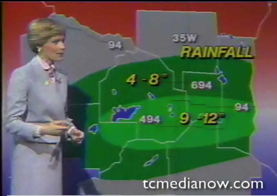
25 years ago, the largest flash flood in Twin Cities history began on July 23, and ended during the early morning hours of July 24.  Known locally as the “Superstorm”, the storm caused damage to 9,000 homes and killed two people.  Value of the damage was estimated at $27 million.  This storm was voted the eighth most significant weather event in the state of Minnesota during the 20th century.

This storm is special to me as It is one of the earliest significant events that I am old enough to remember.  I was seven years old at the time, watching my Dad play softball that evening at Dred Scott Playfield in Bloomington.  As the game progressed, the skies off to the north and west turned an eerie green, and the outdoor sirens sounded soon after.  Play was halted as the participants on the field looked around in confusion at the weather situation.  Realizing that conditions were about to get ugly, people bolted for their cars, using any means necessary to exit the park.  Upon returning home, seeing images on television of streets turning into rivers, and no one being able to venture out anywhere was something I will never forget.  This was my first experience riding out a severe storm locally, and it peaked my curiosity into weather!

During the afternoon hours of July 23, 1987, temperatures were hovering around 90 degrees, with a dew point in the low 70s. This created a very unstable environment for the development of severe thunderstorms and heavy rain as a cold front moving from north to south through the area served as a lifting mechanism.  A tornado watch was issued by the National Severe Storms Forecast Center (pre-Storm Prediction Center) for central and southern Minnesota, including the Twin Cities metro, until 9 p.m.

jul231987tmpdp

Storms developed west of the Twin Cities during the early evening hours, and moved into the northwestern metro after 6 p.m.  Severe thunderstorm warnings were issued at 6:16 p.m. for Wright, Hennepin, and Anoka Counties.  Straight-line winds of 70 mph were reported in these areas.  The storms went tornadic within the hour as a tornado warning was issued for Hennepin and Anoka Counties at 6:40 p.m., followed by a reported tornado at 6:47 p.m. in Maple Grove.  It traveled about five miles into northern sections of Brooklyn Park.  It was later rated as an F3 by the National Weather Service with winds estimated at 158 to 206 mph.  No fatalities or injuries were reported with this twister.  According to Jonathan Yuhas, the twister destroyed 14 homes and damaged over 300 homes and businesses in it’s path.  While there were many reports of tornadoes and funnel clouds across the metro throughout the evening, only one confirmed tornado occurred this day.

maplegrovetornado

The severe thunderstorms transitioned into heavy rain producers as they reached the core of the Twin Cities by 8 p.m.  The frontal boundary stalled over the southern part of the Twin Cities area, and additional storm cells formed along the front throughout the evening and early morning hours.  In a span of six hours, 10 inches of rain fell officially at Minneapolis/St. Paul International Airport (MSP).  To this day, it stands as a record for rainfall in a 24 hour period.  In addition, the largest official single-day rainfall in Twin Cities history occurred on July 23 as 9.15 inches fell over five hours.  During the first three hours, rainfall intensity exceeded 2 inches per hour.  Between the 8 and 10 p.m. hour, the rate exceeded 2.5 inches per hour.  According to Dr. Mark Seeley, this was a once in a 100 year occurrence.  The greatest 60 minute precipitation total during the Superstorm was 2.78 inches.

jul231987precip

By sunrise on July 24, parts of Minnetonka, Hopkins, Eden Prairie, Edina, Bloomington, Richfield and south Minneapolis had received about 12 inches of rain. In northeastern Eden Prairie, a weighted water gage recorded 11.32 inches.

Other rainfall totals from across the Twin Cities:

  • Edina - 11.09 inches
  • Bloomington - 10.36 inches
  • St. Paul (Highland Park) – 9 inches
  • New Hope – 7.83 inches
  • Plymouth – 7 inches

superstormrains  Rainfall totals - KARE News11 Sunrise from July 24, 1987

Water was as deep as 13.5 feet on Interstate 494 near East Bush Lake Road in Bloomington, forcing the road to be closed for nearly 5 days until drainage systems could catch up.

I494flooding 
Flooded Interstate 494 at East Bush Lake Road in Bloomington.  Photo courtesy of KARE11

Flood damage across the Twin Cities was severe.  Just three days before this event, up to nine inches of rain fell over the same areas across the southern metro on July 20 and July 21, setting the stage for flash flooding with any additional rain.  Flood waters from the Superstorm closed many roads, and vehicles were completely submerged.  Storm sewers could not keep up with the deluge, causing water to gush out of manholes like geysers.  Minnehaha Creek and the Nine Mile Creek were turned into raging rivers, threatening residences and roads along it’s banks.  One person died in Hopkins when his vehicle was swept into Nine Mile Creek.  Thousands of basements were flooded, and some roofs collapsed.  A man in south Minneapolis was killed in his basement when a foundation wall collapsed on him.  Water entered businesses along flooded roadways, and the ground level of the Southdale Center in Edina was covered with one to three inches of standing water.  Some stores sustained water damage.  Stranded shoppers stayed overnight inside the mall.

The two heavy rain events during the month (July 20-21 and July 23-24) combined to give the Twin Cities it’s wettest summer on record, with 23.52 inches of rain falling from June to August.  Total annual precipitation in 1987 was 32.16 inches.  Of that total, nearly 56 percent of that fell in July, and 31 percent of the precipitation that year occurred during the Superstorm.

Additional resources:

RS

Tuesday, July 10, 2012

Hot start to July

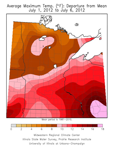
July started out of the gates at a record pace with very mild temperatures - well above the norm for this time of the year.  During the first six days of the month, high temperatures have been 12 to 15 degrees above normal across the southeastern part of Minnesota.  The Twin Cities has already seen two 100-degree plus days this month, which has not happened in 24 years.

MaxTdeparture_Jul12

As of July 9th, the average high temperature in the Twin Cities is a sweltering 94.7 degrees.  The typical maximum temperature is around 83 degrees.

MSPhightemps_071012

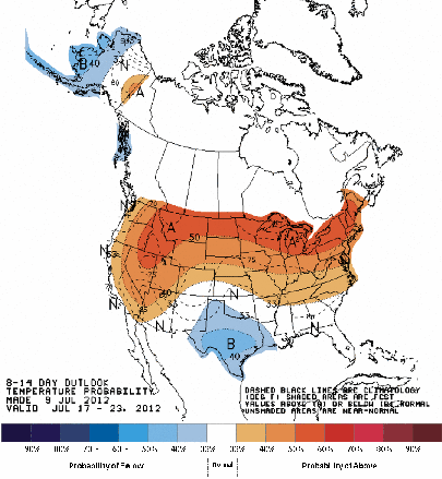
The Climate Prediction Center seems to think the hot trend will continue throughout July.  It is forecasting above normal temperatures over the next 14 days for the northern two-thirds of Minnesota.

814temp_new_Jul0912

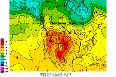
What is responsible for this mild, dry weather pattern?  A dome of high pressure is located out in the Rockies.  Northwest winds in the upper levels of the atmosphere will draw in the warmth across the state.

850tmpcf144_071612

Right now, it appears that Wednesday and Thursday have a chance of seeing 90 degree temperatures in the Twin Cities.  Seeing a 90 in for a high temperature this weekend would not be out of the question either.

MSPmeteo_071012

The heat will stick around into next week as temperatures remain well above average.  There is a pretty good chance that July 2012 will go down in the books as the warmest July on record.  The warmest July on record is 81.4 degrees in 1936.

RS

Monday, July 9, 2012

A reminder why thunder and lightning do not require rain

During the fourth inning of Sunday night’s baseball game between the Texas Rangers and Minnesota Twins, a sudden bolt of lightning, followed by loud thunder struck near Rangers Ballpark.  Players and umpires immediately (and rightfully) exited the playing field.  Rangers officials said the lightning struck north of stadium and did not hit the facility. There were no reports of damage or any injuries.

Although scattered storms were in the area, no rain was occurring inside the stadium.  Was this a bolt of lightning out of the blue?  Was some higher calling paying a visit?  Actually, there was nothing out of the ordinary with this event other than the proximity of the thunder and lightning to the stadium made for a scary situation.  According to the National Oceanic and Atmospheric Administration (NOAA), lightning can strike outwards of 10 miles from a thunderstorm.  Because of this, it may seem as if lightning came from “out of the blue”.

Lightning is a phenomenon to take seriously.  It is in the top three for storm-related killers in the United States.  If you hear thunder, you are already in danger of becoming a lightning victim.  One method used to calculate the distance of a storm to your location for safety purposes is to count the seconds between the flash of lightning and the crack of thunder and divide by 5.  If the storm is within 10 miles, find a safe shelter such as a substantial building or an enclosed metal vehicle, and wait for the storm to clear.

RS

Saturday, July 7, 2012

Summary of recent heat wave and capping inversions explained

The heat wave concluded Friday night as a cold frontal boundary pushed from north to south across the southern half of Minnesota, and triggered a few rain showers and thunderstorms.  The hot weather went out with a bang as the high temperature in the Twin Cities reached 102 degrees.  It was also the first time since 1988 that one month has seen at least two days with temperatures at 100 degrees or above.

The stretch of eight days from June 29 to July 6 with high temperatures at 90 degrees or above has happened on five other occasions in the Twin Cities.  The average high temperature during this period was 96.4 degrees, and the average temperature was 84.5 degrees.  This would make it the 4th warmest heat wave ever based on mean temperature!

Date

High Temp

Record Temp

Year

6/29/12 90 102 1931
6/30/12 92 100 1931
7/1/12 94 100 1883
7/2/12 99* 96 1911
7/3/12 97 100 1949
1990
7/4/12

101*

100 1949
7/5/12 96 100 1982
7/6/12 102 104 1936
* = Indicates new record

The sagging frontal boundary was very visible on radar Friday night.  Thunderstorms developed along the leading edge on this boundary, but had a hard time surviving.

MPX_N0R_1207062357_912x684_none__0865_an

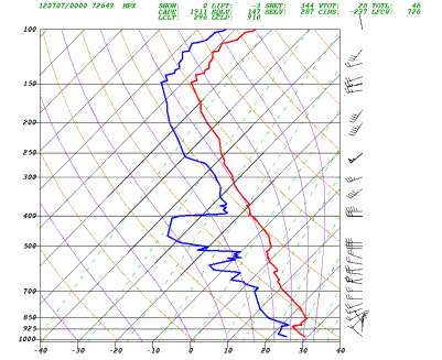
Why did the storms die off so quickly?  There was a capping inversion in the atmosphere.  What that means is there was a layer of warm (stable) air stacked on top of a colder layer.  Cloud formation from the lower layer is "capped" by the inversion layer.  Convection requires warm air rising into cold air.

Shown below is a temperature profile at the National Weather Service in Chanhassen at 7 pm Friday.  While temperatures (red line) initially decrease with height from the surface, temperatures increased with height from 925 millibars (~2500 feet above sea level) to 850 millibars (~4600 feet above sea level).  The limited how much storms could grow, even when there is plenty of energy for them to work with.

12070700

Dr. Greg Forbes from The Weather Channel briefly explains in the video clip below how the cap prevents thunderstorms from happening:

RS

Friday, July 6, 2012

A few strong to severe thunderstorms mainly west and north of the Twin Cities today

A meandering frontal boundary across southern Minnesota will be the focus for thunderstorm activity on Friday.

94fwbgus_070612

Strong to severe thunderstorms will be possible across central into southwestern Minnesota near a low pressure center.  A capping inversion is forecasted to break by the afternoon to allow storms to develop.

RAP_255_2012070610_F15_EHI3_SURFACE

The high-resolution WRF model places heavy (severe?) thunderstorms across southwest Minnesota by 7 pm.  MSP is represented by the red dot.  Any thunderstorms that do develop across southern Minnesota will affect the Twin Cities after midnight, and will likely be a marginal severe weather threat.

4kmWRF_070612

Another one of the models paints the heaviest of the weather to the north, near the Lake Mille Lacs area.  So there is some disagreement within the models are where the storms will form today, therefore a broad area from east central into southwestern Minnesota will be highlighted for the threat of severe thunderstorms.

rad26_070612

The main threats from any severe thunderstorms will be large hail and damaging winds.  Another factor will the heavy rains.  Between now and 6 am Saturday, one to two inches of rain is possible across the Northland.  This is an area that does not need anymore rain.  Duluth is still drying out from flooding, and water levels on the lakes and rivers that run through Aitkin County are high.

fill_94qwbg_070612

There is still a bit of uncertainty with today’s severe weather setup, but it is always a good idea to have a means of receiving weather alerts ready to go.

RS

Heat wave summary in the Twin Cities

The-heat-index-is-somewhere-between-OMG-and-WTF
Since June 29th, the high temperature in the Twin Cities has been at 90 degrees or above.  Combined with high dew point values, the heat index has reached in excess of 100 degrees for several periods during the heat wave.  New high temperature records were set on July 2 and July 4, as the mercury climbed to 99 and 101, respectively.  The daily high temperature reached 100 degrees or more for the 34th time since 1873 over the Fourth of July.
 

Date

High Temp

Record Temp

Year

6/29/12 90 102 1931
6/30/12 92 100 1931
7/1/12 94 100 1883
7/2/12 99* 96 1911
7/3/12 97 100 1949
1990
7/4/12

101*

100 1949
7/5/12 96 100 1982
* = Indicates new record
 
July 4th also marked the first time since 1995 an hourly observation at MSP Airport recorded a temperature of 100 degrees or more with a dew point of 70 or greater.  That statistic was impressive to me.  We do not often hit 100 degrees here, and to do with tropical humidity like this is quite an accomplishment.  A heat index of 109 was observed from my home in Shakopee at 7:15 pm Thursday.
 
548322_10150915253752544_1372633222_n
 
RS

Tuesday, July 3, 2012

Just how rare is this heat in the Twin Cities?

The high temperature barely missed hitting the century mark in the Twin Cities on Monday as the mercury peaked at 99 degrees.  However, this did break the previous record of 96 degrees set over a century ago in 1911.

Just how often do we see these hot temperatures in the Twin Cities?  In the past 30 years, the temperature reached 100 degrees or more only 10 times.  That is once every three years on average.  The most recent 100 degree or higher reading was last year on June 7, when the temperature hit 103 degrees.  In most cases to top triple digits, a lower dew point, below the mid-60s, is needed for air to mix down to the surface efficiency.  Not often do you see temperatures greater than 100 when the dew point is at 70 degrees or more.  Here is a look at a few case studies:

On June 7, 2011, temperatures climbed as the dew point decreased.  Temperatures reached the 100 degree mark when the dew point dropped into the high 50s.  A humidity level in the “comfortable” range for most people.

060711_temp_dp

The opposite was found to be true on July 31, 2006.  On this day, the maximum temperature of 101 was obtained as the dew point was rising steadily.  At 4 pm, the dew point was 68 degrees as the temperature peaked.  Would the temperature have hit 100 if the dew point was at 70?  Close call, but probably not.  98 or 99 degrees would have been more likely in that instance.

073106_temp_dp

Jumping back over 10 years from 2006 to 1995 was the next occurrence of temperatures 100 degrees or greater.  July 13 was the date as temperatures soared to 101 degrees yet again.  This was one of the few times where the temperature hit 100 degrees as the dew point was over 70 degrees.  When this happened at the 4 pm hour, the dew point observation was 71.  The heat index was 109.

071395_temp_dp

Monday’s 99 degrees was reached as the dew point was 67 degrees at the 6 pm hour.

RS

Monday, July 2, 2012

Urgent notice for Bemidji residents

THE FOLLOWING MESSAGE IS TRANSMITTED AT THE REQUEST OF THE BELTRAMI EMERGENCY MANAGEMENT:

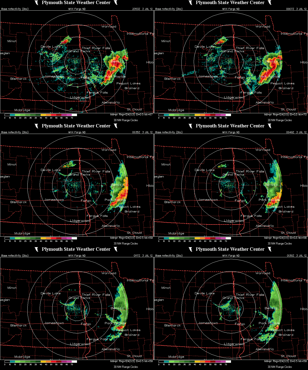
“EMERGENCY TRAVEL ONLY IS BEING ADVISED IN THE CITY OF BEMIDJI AT THIS TIME DUE TO EXTENSIVE STORM DAMAGE. THIS DAMAGE INCLUDES NUMEROUS POWER-LINES DOWN...NUMEROUS AND SIGNIFICANT TREE DAMAGE AS WELL. ALL PHONE SYSTEMS ARE DOWN EXCEPT FOR 911 FOR EMERGENCY CALL ONLY.”

Some of the storm reports from the Bemidji area:

  • Bemidji [Beltrami Co, MN] law enforcement reports TSTM WND DMG at 07:00 PM CDT -- numerous trees down throughout the city of bemidji. street flooding as well.
  • Bemidji [Beltrami Co, MN] broadcast media reports NON-TSTM WND DMG at 07:05 PM CDT -- public report of a 60 ft spruce tree broken off about halfway up the tree with other limbs down in the area ... posted on kvly facebook site

In addition to damage in Bemidji, visitors at Lake Itasca State Park are trapped inside the park due to trees down across the exit.   Winds were estimated around 80 mph.

Radar image from earlier in the evening:

MVX_4519_an

RS

Hot, with severe thunderstorms possible over the Northland

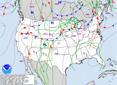
A warm front, or is this instance, a “hot” front will move to the International border by this evening.  This front will be the focus for thunderstorms, some of which will be severe across the north.  To the south of the front, very warm air will dominate the state today.

94fwbgus_070212

The greatest area of concern for severe thunderstorms is north of a St. Cloud line, but the focus for storm development will be near the warm and cold front intersection.

NAM_221_2012070200_F21_EHI_3000_M

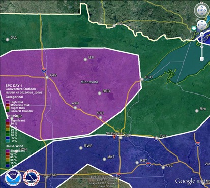
The Storm Prediction Center has indicated hail as the greatest threat today, with the purple area below as the area at risk.

hailthreat_070212

Unlike yesterday’s setup, a tornado threat does exist today as an area of low pressure moves into the northwest portion of the state.  Areas northwest from Bemidji may see an isolated risk of a tornado during the early stages of severe weather.

NAM_221_2012070200_F24_EHI_1000_M

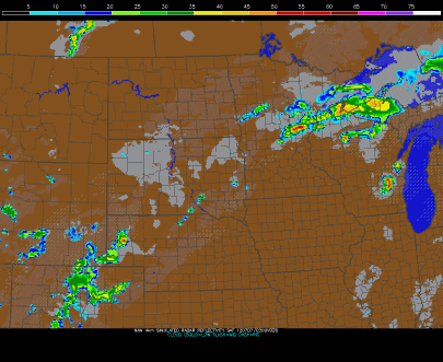
The high-resolution WRF model at 7 pm below depicts a bow echo moving through the Northland tonight, with a secondary bowing mesoscale convective system forming near Fargo and moving southeastward.  The Fargo bow misses the Twin Cities to the north.

rflslp24_070212

Further south, it is just going to be hot.  Dew points in the 70s will keep temperatures from reaching 100, but highs around 95 degrees should be doable today in the Twin Cities.  The mid 90s will dominate most of southern Minnesota.

MNtemps_070212

A heat advisory is in effect for the southern half of Minnesota today until 10 pm as heat indices will top 100 by the afternoon.

heatadv_070212

Stay cool today!

RS

Sunday, July 1, 2012

Strong to severe thunderstorms for the area tonight

Temperatures close to 95 degrees with dew points near 70 will create an unstable environment for thunderstorms to work with tonight.

simuawipsCAPE_070112

A couple of the high-resolution models show storms initiating close to the Twin Cities during after the dinner hour going into the night.

rad14_070112

rflslp23_WRF070112

The Storm Prediction Center is indicating a slight risk of severe thunderstorms for far southern Minnesota with wind and hail as the primary threats.

svrthreatDay1_07012012

There may be brief periods of severe thunderstorms, but most of the activity should remain below severe limits as strong storms.  Just something to keep an eye on for those getting an early start on 4th of July celebrations.

RS