Saturday, June 30, 2012

First heat wave of the year

The first stretch of heat of 2012 will be upon us over the next several days as the jet stream lifts into Canada, allowing very mild air to travel northward across the area.

wrfUS_250_spd_72

Our weather will be dominated by a ridge with Minnesota being on the northern periphery of a dome of high pressure sitting out in the Four Corners region.

850tmpcf72

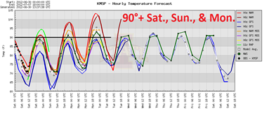
The NAM model is hinting at our first chance of 100 degrees on Monday.  Lately, the NAM has been overdoing the high temperatures a bit, as it has some trouble with handling dew point temperatures.  It will depend on dew points.  If the air can remain relatively dry and dew points stay in the low 60s, then I think we have a legitimate shot of hitting 100 degrees Monday in the Twin Cities.

heatwaveJunJul12

The record for July 2nd is 96 degrees, set in 1911.  Will a new record be set Monday?  Stay tuned!

RS

Thursday, June 28, 2012

Wireless Emergency Alerts: What it means to you

The wireless industry joined the Federal Communications Commission (FCC) and Federal Emergency Management Agency (FEMA) to offer a robust and reliable wireless emergency alert system - Wireless Emergency Alerts (WEA).  They are not text messages, rather these alerts use a different kind of technology to ensure immediate delivery on wireless networks.  There are three types of WEA: Presidential Alerts, Imminent Threat Alerts (i.e. natural disasters), and AMBER Alerts.  Consumers may opt out of Imminent Threat and AMBER alerts, but not Presidential Alerts.  Alerts are location-specific using a point-to-multipoint system, so messages will be sent to those within a targeted area.  If traveling into an affected area after the original alert has been issued, messages will still be received as they are re-broadcast throughout the duration of the alert time.

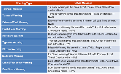
Weather-related alerts from the National Weather Service will include the following:

WEAHazards

Who receives the alerts?  It all depends on carrier and device.  Right now, there are a limited number of phones that offer this capability.

Here is the current availability of WEA on major carrier networks.  More phones are expected to be added during 2012 through software updates, including the popular Apple iPhone, with iOS 6 expected to be released in the fall.  For Apple users, I still recommend installing the iMap Weather Radio app ($9.99).  It is well worth the money, and includes extras, such as five-day forecasts, radar, and tropical system tracking.

AT&T

  • Samsung Galaxy SII (SGH-i777)
  • Samsung Captivate Glide (SGH-i927)
  • Motorola Atrix 2 (mb865)

Sprint

  • Sanyo Inuendo
  • Sanyo Vero
  • Sanyo Milano
  • HTC EVO 3D
  • Samsung Galaxy SII 4G Touch
  • LG Marque
  • Kyocera DuraMax
  • Kyocera Duracore
  • Kyocera Brio
  • Samsung Trender
  • HTC EVO Design 4G
  • Samsung Transform Ultra.

Verizon

  • Droid X by Motorola
  • Droid 2™ by Motorola
  • Droid 2 Global
  • Droid Pro by Motorola
  • Droid RAZR by Motorola
  • Droid RAZR MAXX by Motorola
  • Motorola Bionic LTE by Motorola
  • LG Cosmos™ 2
  • LG Revere™
  • LG Enlighten™
  • Lucid™ by LG
  • Verizon Jest 2
  • Samsung Convoy™ 2

With the increased usage of smartphones, this is another vital way to receive real-time weather alerts.  The Shakopee Valley News recently published an editorial regarding not relying on sirens to stay safe.  This is a point I have been making all year.  We need as many safety nets as possible.  Cell phones have a battery, and will work in power outages (granted it has a charge), whereas outdoor sirens will not.  NOAA Weather Radio, with a battery backup feature, is another option.  While this technology will alert for approaching storms, the downfall is that it operates under a county-based system.  This leads to the possibility of being awaken at night to storms in your county, but not necessarily approaching or affecting your location within the county.  While we are heading past the peak of severe weather season, now is the time to prepare for the remainder of the summer.

RS

Tuesday, June 26, 2012

First real dose of heat this year

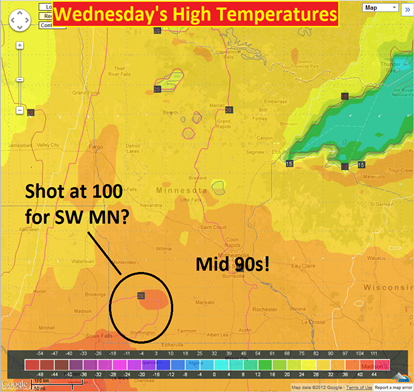
Perhaps the warmest day of the year for the Twin Cities is on tap Wednesday as high temperatures push into the mid-90s.  The mercury has topped out at 93 degrees on three occasions this year, including twice on June 10 and 19.  Combined with high humidities, the heat index, or “feels like temperature”, will exceed 100 degrees.  Air temperatures may approach 100 degrees across southwest Minnesota.

Jun272012heat

I think there will be a chance of seeing heat advisories issued for Wednesday as heat indices approach 105 degrees.  You will want to take it easy and drink plenty of water.  As the National Weather Service in Chanhassen states, “NEVER leave anyone unattended in an automobile. It takes less than a few minutes for the temperature to rise above safe levels. People (or pets) can die of hypothermia, even if the windows are cracked.”

RS

Monday, June 25, 2012

Shakopee’s freak wind storm

A wind storm blew through Shakopee last Wednesday between 9:30 am and 10:00 am.  This storm toppled a tree at the Donahue residence on Jade Circle, but neighboring trees were unharmed, other than a fallen branch.  So what caused this tree to fall?  Was it straight-line winds, tornado, or something else?  This blog post will attempt to answer that question.

 Photo submitted to the Shakopee Valley News

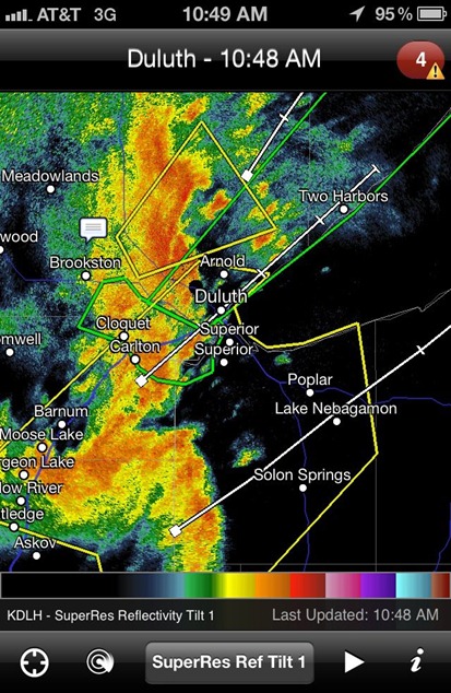
During the morning hours of the 20th, a thunderstorm complex moved from west to east across Minnesota.  As it approached the Twin Cities, it began to die out, with strong to severe thunderstorms ongoing north of the Twin Cities.  An outflow boundary, or gust front, was created with the southern flank of the boundary moving through the Shakopee area just before 9:40 am.

MPX_N0R_1206201439_912x684_KFCM__0865

The sudden burst of winds, combined with a saturated ground from recent rainfall, was likely the culprit for the tree damage at the Donahue residence. 

An automated weather station located near Jade Circle recorded observations approximately every ten minutes.  Checking the history for June 20, 2012 at Weather Underground, it revealed wind gusts to 16 mph at 9:34 and 9:44 am.  It is entirely possible that winds were higher between observation intervals.  Flying Cloud Airport in Eden Prairie recorded a 27.6 mph wind gust at 9:53 am, therefore winds to 30 mph were not out of the question.  Since the tree did not snap, nor were roots exposed, it is reasonable to believe that winds did not reach severe levels of 58 mph or greater.

wxstationlocation

The south metro had been inundated with rain and wet soils as June 20 approached.  National Weather Service imagery shows 30-day precipitation amounts as of noon on Monday, June 18th in the eight to ten inch range for rainfall.  With the ground this saturated, it would not take much wind force to knock down trees.

precip0618

it is of this weather enthusiast’s opinion that the felled tree was the result of a sudden burst of wind to 30 mph, with water-logged soil that could not longer support the tree.

RS

Friday, June 22, 2012

Aftermath of historic Duluth flooding

Rain continued into the day on June 20th, and finally ended when a strong cold front moved through Wednesday afternoon.

600307_10150886732552544_798346428_n

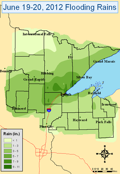
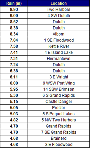
Officially, another 3.10 inches of rainfall was added Wednesday, bringing the total to 7.24 inches over the two days. However, many locations around Duluth saw as much as 10 inches of rain.

Precip_map

preciptableDLH

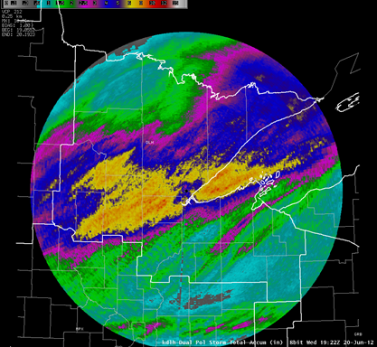
The Duluth radar shows where the heaviest rain occurred during the historic flood event.  The North Shore to Aitkin County has been declared a disaster area.  Duluth Mayor Don Ness believes that damage from the flooding will be $100 million region-wide.

DP_STA

The mayor claims that “Duluth and the region is open for business … Duluth is safe”, but visitors must be very careful traveling on roadways.  Many of them are compromised with unstable foundations from the flooding.  Sinkholes and washouts are still possible on city roads, even after the rain.  Canal Park is said to be safe to visit, but areas on Duluth’s hillside are still experiencing flooding.  If you are planning to travel to Duluth soon, stay safe!

RS

Wednesday, June 20, 2012

Major flooding in Duluth

A record daily rainfall of 4.14 inches in Duluth on Tuesday triggered flash flooding in the city.  It is believed to be one of the worst flooding events to affect the city 40 years.  Pictures and video from The Weather Channel can be seen here.

A SIGNIFICANT LIFE THREATENING FLOOD EVENT WILL CONTINUE ACROSS THE TWIN PORTS...NORTH SHORE OF LAKE SUPERIOR...AND PARTS OF NORTHWEST WISCONSIN. TRAVEL IS NOT RECOMMENDED IN THE TWIN PORTS EARLY THIS MORNING. THUNDERSTORMS WILL FOCUS ACROSS MOST OF THE NORTHLAND TODAY. DUE TO UNUSUALLY HIGH AMOUNTS OF MOISTURE IN THE ATMOSPHERE...RAINFALL RATES AT TIMES WILL APPROACH 1 TO 2 INCHES PER HOUR. FLOODING WILL CONTINUE TO BE EXACERBATED BY ADDITIONAL RAINFALL. PLEASE REFER TO THE LATEST FLOOD WATCHES AND WARNINGS ISSUED BY THE NATIONAL WEATHER SERVICE IN DULUTH.

Some locations near Duluth saw almost eight inches of rain in one day!

  • Duluth [St. Louis Co, MN] nws employee reports FLOOD at 12:24 AM CDT -- water over the road at highway 53 and maple grove road.
  • Duluth [St. Louis Co, MN] broadcast media reports FLOOD at 02:26 AM CDT -- numerous roads are washed out or flooded within duluth. this includes several sinholes and collapsed roads. reports of high water rescues and evacuations in progress across the city.
  • Duluth [St. Louis Co, MN] broadcast media reports HEAVY RAIN of M6.38 INCH at 02:27 AM CDT -- lester park

Additional reports in the graphic below:

duluthflooding

From the Duluth Police Department:

I-35 IS SHUT DOWN IN BOTH DIRECTIONS AT 40TH AVE W AND IN THE DOWNTOWN TUNNELS AS THE ROAD IS IMPASSABLE DUE TO FLOODING. HIGHWAY 23 IS SHUT DOWN IN FOND DU LAC DUE TO FLOODING. HIGHWAY 61 IS IMPASSABLE ALONG THE NORTH SHORE DUE TO FLOODING. THE FOND DU LAC NEIGHBORHOOD IS BEING EVACUATED AS FLOODING IS EXPECTED DUE TO INCREASED WATER RELEASE FROM THE FOND DU LAC DAM. OFFICIALS REPORTED NUMEROUS SINKHOLES...ROADS WASHED OUT AND MUDSLIDES ACROSS THE CITY OF DULUTH. ONLY EMERGENCY TRAFFIC IS ADVISED.

Definitely an ugly situation up on the North Shore.  Travel to the area is not advised.  I was just up there last weekend for Grandma’s Marathon.  It is amazing what a  difference a couple days makes.  Fortunately, most of the visitors for the race have already left town, minimizing the impact to life.

122

RS

Monday, June 18, 2012

Active Sunday evening across Minnesota

A line of strong to severe thunderstorms moved through west central and east central areas of Minnesota Sunday night causing high winds, flooding, and numerous funnel cloud reports.  The line weakened as it approached the Twin Cities as drier, more stable worked into the system from convection earlier in the day.

MPX_N0R_1206180357_800x600_none__2595_an

Dew points were most impressive across northeastern South Dakota and far west central Minnesota at 7:30 pm Sunday.  Despite the models printing a large MCS (mesoscale convective system) coming into the Twin Cities by 10 pm or so, I knew it was going to lose a bit of punch, and questioned whether it would be severe by the time it arrived into MSP.  I think weather folks tend to get too excited about what the computers are telling them and assume the worst without looking at other information.  One can not forget the basics, such as surface observations.  Have to ask yourself, “Does this model solution make sense?”

MSLDPWinds_061712

Only one official tornado report was received Sunday east of Wheaton, Minnesota.  There were many reports of funnel clouds and thunderstorm wind damage across west central Minnesota.  The highest wind gust observed was 77 mph in the town of Cosmos at 9:56 pm.

stormreports_061712

The National Weather Service offices were busy issuing warnings all night.  Tornado warnings clipped the far west metro, and severe thunderstorm warnings extended all the way to the St. Croix River.  The Twin Cities saw heavy rains, two to three inches, on already saturated ground, triggering flash flood warnings.

nwswarn_061712

It was definitely a busy night, and we could see more storms on Tuesday.  Look for additional updates as they are warranted!

RS

Wednesday, June 13, 2012

Severe weather possible Thursday

Warm and humid air will work it's way into Minnesota by Thursday, which will create an unstable air mass for thunderstorm development as a cold front moves through the area during the evening hours.

98fwbgus_061512

Isolated severe thunderstorms will be possible in the warm sector (behind the warm front and ahead of the cold front) across the southern two-thirds of Minnesota Thursday night.

NAM_221_2012061300_F48_EHI_3000_M

The veering of winds is much more impressive with this system than the Sunday storm.  The upper, lower, and surface level winds are forecasted to be from the southwest, west, and southwest, respectively.

250 mb:

NAM_221_2012061300_F48_WSPD_250_MB

500 mb:

NAM_221_2012061300_F48_WSPD_500_MB

850 mb:

NAM_221_2012061300_F48_WSPD_850_MB

The wind shear profile seems to be favorable for tornadoes, and surface-based convection is likely.  I wouldn’t be surprised to see a tornado watch issued during the afternoon hours on Thursday.

NAM_221_2012061300_F48_EHI_1000_M

You will want to keep an eye to the sky if you have Thursday outdoor activities, as this storm will mean business if we get the necessary daytime heating.

RS

Monday, June 11, 2012

Did the Sunday storms produce a tornado?

As expected, a line of strong to severe thunderstorms rolled across Minnesota Sunday night ahead of a cold front.

MPX_N0R_1206110200_800x600_none__173_an

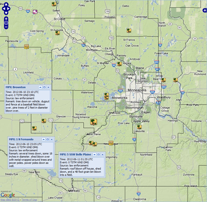
Widespread damaging wind reports were received throughout the state, and at one time, 18,000 Xcel Energy customers were without power in the Twin Cities.  Some of the more interesting storm reports received that involved structural damage are below.  The majority of the wind reports involved tree damage.

svrstormreports_061012

Things really become interesting after 8 pm when a tornado warning was issued at 8:18 pm on a cell heading into southwestern Scott County.

* AT 814 PM CDT...RADAR INDICATED A STORM CAPABLE OF PRODUCING A TORNADO. THE MOST DANGEROUS PART OF THE STORM WAS 6 MILES SOUTHWEST OF BELLE PLAINE...OR ABOUT 4 MILES EAST OF HENDERSON...AND MOVING NORTHEAST AT 50 MPH.

torwarn061012

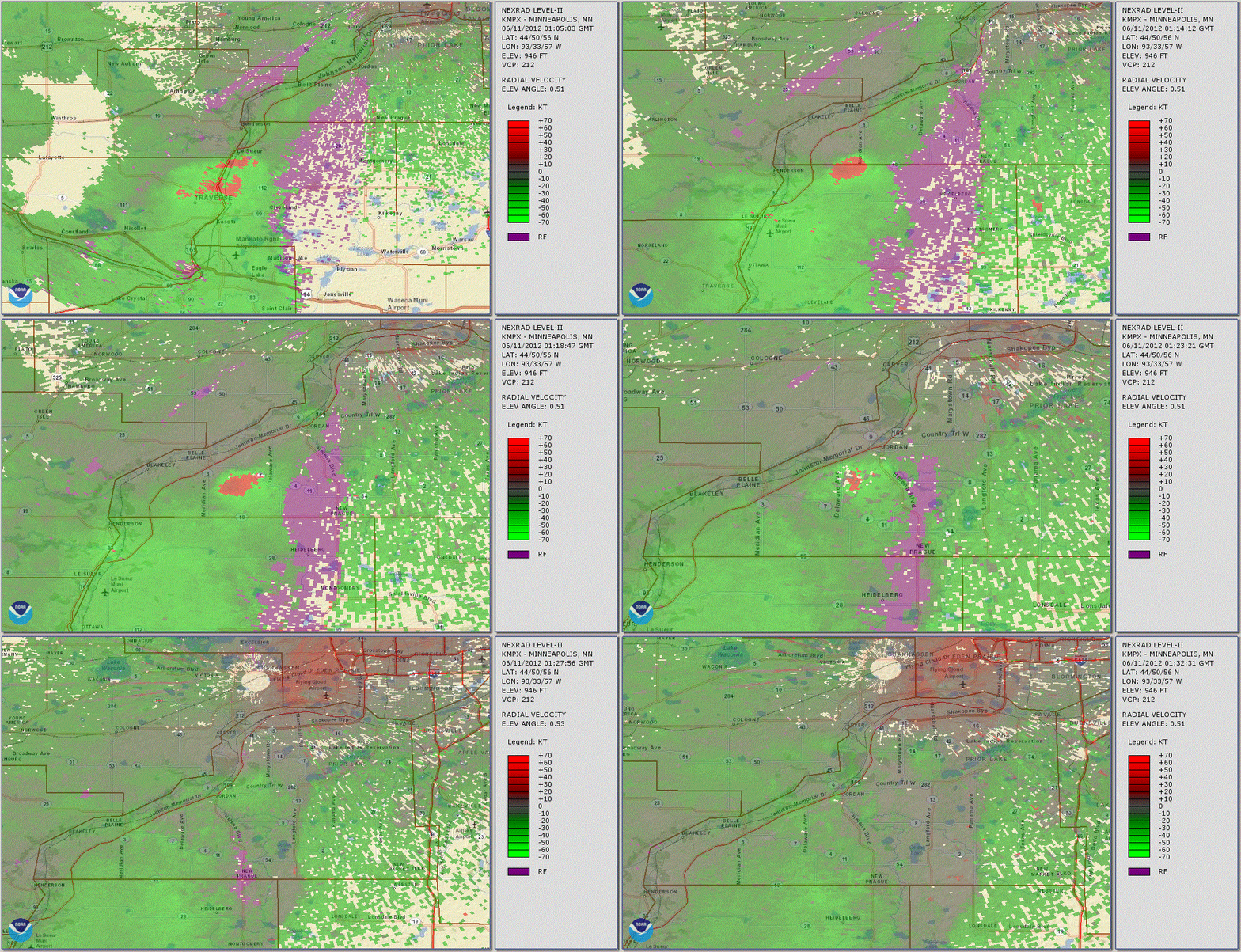
Strong rotation was detected on radar as the cell travelled between Belle Plaine and Jordan.  Damage in the Belle Plaine area included, “Roof blown off house, shed down, and a 48 foot grain bin blown into a field.”

belleplainerotation

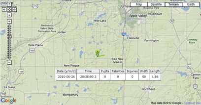
Was this a tornado?  Based on what I have seen on radar, there is pretty good evidence that it was.  However, the National Weather Service in Chanhassen will conduct a formal damage survey to determine if the damage was caused by straight-line winds or a tornado.  If it is indeed ruled a tornado, this would be the first tornado to impact Scott County in almost two years.  The last tornado in the county occurred on June 26, 2010 near Elko New Market.  Damage was reported to trees and a silo in that storm.

scottco2010tor

RS

Sunday, June 10, 2012

Storms still set to arrive tonight

Storms are projected to develop late this afternoon across west central Minnesota and push through the state during the night ahead of a cold front sweeping through today.

coldfront_06102012

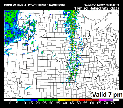
All of the models are depicting a line of storms, some of which will be severe within embedded cells, lining up north to south across the state by the evening hours.

rad22_061012_22z

1ref_t2sfc_f14_06102124kWRF_06102012

One inch or greater hail is the primary concern with these storms today, according to the Storm Prediction Center.

SPChail_0610212

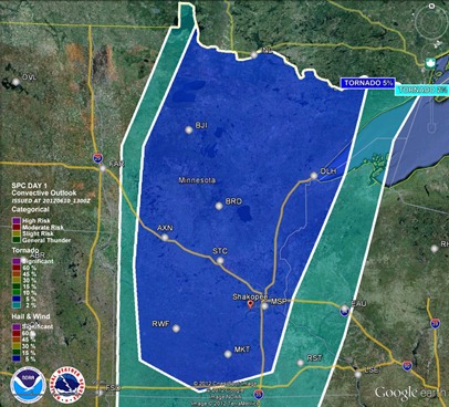
There is also an isolated tornado threat, mainly during storm initiation across a large portion of the state.  I still believe the greatest threat for tornadoes will be north of a Brainerd line.

SPCtor_06102012

Keep it tuned here for additional updates throughout the day!

RS
Saturday, June 9, 2012

Severe weather likely to close out the weekend

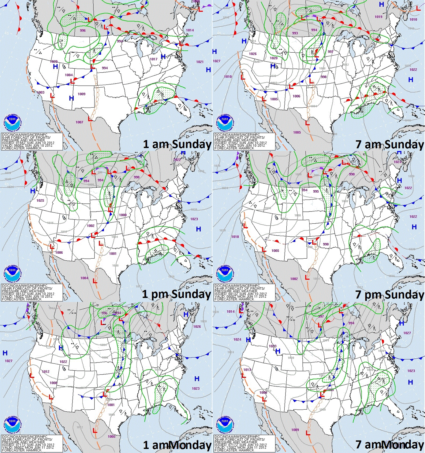
A cold front is expected to sweep through Minnesota during the day Sunday, which will bring a good chance of thunderstorms, some severe, to the region.

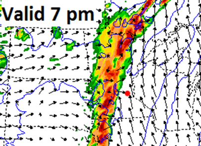
Cold front position at 7 pm Sunday:

98fwbgus_061012

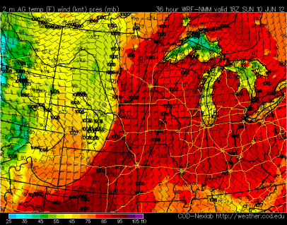
Out ahead of the front, conditions will be hot and muggy on Sunday.  Temperatures are forecasted to be in the mid-90s with dew points approaching 70 degrees.

Temps:

wrfGL_2_temp_36

Dew point:

wrfGL_2_dewp_42

This will result in a very unstable atmosphere for thunderstorm development.  There will be more than enough energy for storm initiation once the cold front begins to move into the state.

wrfGL_0_cape_36

The greatest risk for severe weather will be over the central and northern sections of Minnesota.  Roughly from the St. Cloud area, and northward.  However, an isolated severe storm is possible for the Twin Cities metro.

NAM_221_2012060900_F42_EHI_3000_M

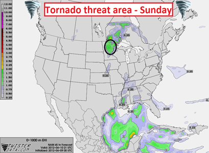
The overall primary concerns from the Sunday storms are large hail and damaging winds.  A tornado risk does exist closer to the intersection of the cold and warm fronts in northern Minnesota – Brainerd lakes vicinity and north.

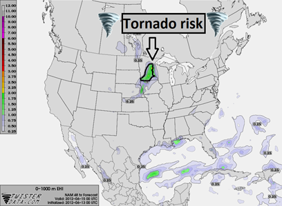
NAM_221_2012060900_F45_EHI_1000_M

If you are going to be out on the lake during the latter half of the weekend, make sure to have a NOAA Weather Radio with you, and keep an eye on the western horizon for darkening skies!

RS

Wednesday, June 6, 2012

Meteorological Spring 2012 recap

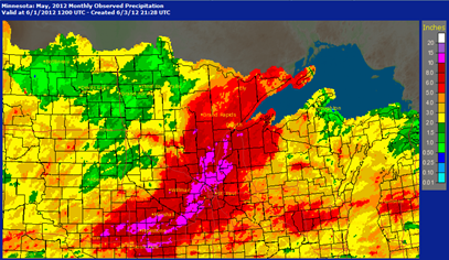
The month of May finished warm and wet across much of the state, which was typical of spring.  Both Minneapolis and St. Cloud recorded the second wettest May on record with 9.34" and 8.76" of rainfall, respectively.  A large swath of Minnesota saw anywhere between two to four times normal precipitation for the month. 

mayppdev

During the month, as much as ten inches of rain fell just west and north of the Twin Cities, causing area rivers to rise rapidly to near or at flood stage.  The National Weather Service in Chanhassen recorded 11.23" of rainfall in May.  Over half the days in May brought measurable rainfall.

May2012precip

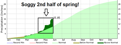
Soggy conditions persisted through the second half of the meteorological spring with central Minnesota receiving more than normal rainfall for the season to eliminate drought concerns by the end of May across the same areas.  The total precipitation in the Twin Cities from March to May this year was 13.78 inches, or 5.87 inches above normal.  Precipitation at MSP as of May 31, 2012 is 15.85 inches.

rainsurplus_spring12

springppdev_12

mn_dm_05292012

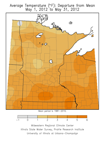
May was also known to be a mild month.  Nearly the entire state saw temperatures above the mean.  The Twin Cities was 4.6 degrees above normal, with St. Cloud also checking in above normal at 3.8 degrees.

maytempdev

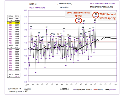
May contributed to the warmest spring on record for locations in central and southern Minnesota including the Twin Cities, St. Cloud and Rochester.  The Twin Cities recorded a mean temperature of 54 degrees.  Duluth tied the warmest spring on record, and International Falls had the fourth warmest spring.  March 2012 was the main reason for the extremely warm spring, and nearly single-handedly carried the seasonal average to the number one warmest!

MSPspringtemphistory

It was quite the unusually spring with a little bit of everything, from droughts to floods, and an unprecedented mild March!  If spring was any indication, summer will be quite the three month ride.  Buckle up!

RS