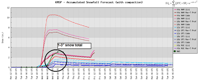
Looking at the 00z NAM model data, it appears the snow will begin to fall between 7-9 PM Tuesday and be continuous through the afternoon on Wednesday. Liquid precip amounts will be running around .35 inches. Using a 8-to-1 snow ratio average, it equates out to roughly 3 inches of snow, which will be the high end of the snow total range.

Looking at all the available model output, the general consensus seems to be from 1 to 3 inches of snow across the Twin Cities metro. Since temperatures will be hovering right around freezing, we will not see fluffy snow. Just some thick, wet flakes as the changeover happens from rain to snow.

The Wednesday morning commute could be a little slow, as the GFS model advertises the heaviest of the snowfall will occur. The temperature profile below at 7 AM Wednesday shows all layers of the atmosphere below freezing (0°C) all the way up to 25,000 feet above the earth’s surface. That’s impressive for this time of the year!

To wrap this up, I’m expecting 1-3 inches of snow for the metro with heavier amounts across southeast Minnesota, where they could be closer to the 4-6 inch snowfall range. Places such as Red Wing, Rochester, and towards La Crosse, Wisconsin. Spring is being casually late this year due in part to the La Nina winter we experienced. With the effects of La Nina diminishing, hopefully we will find some balance and that our summer will be beautiful. Still too early to say for sure, but my hunch is that the middle part of summer could very well be hot and dry. Something I will keep my eye on, that’s for sure. We’ll make it through this.
Latest watches and advisories:
Winter Weather Advisory valid at Apr 19, 7:00 PM CDT for Anoka, Blue Earth, Brown, Carver, Chisago, Dakota, Faribault, Freeborn, Goodhue, Hennepin, Le Sueur, Martin, McLeod, Nicollet, Ramsey, Rice, Scott, Sibley, Steele, Waseca, Washington, Watonwan [MN] and Barron, Chippewa, Dunn, Eau Claire, Pepin, Pierce, Polk, Rusk, St. Croix [WI] till Apr 20, 12:00 PM CDT
RS


No comments:
Post a Comment