My first chase of the 2011 severe thunderstorm season took place on Sunday, April 10. I had been anticipating a tornado outbreak to occur several days in advance as all the dynamics were coming together to set the stage for explosive thunderstorm development with enough wind shear for tornado development. In the end, the day turned out to be a bit of a bust as storms failed to muster anything noteworthy in my target area.
The Storm Prediction Center (SPC) had put out a moderate risk of severe weather in the early morning hours for much of Wisconsin into northern Illinois during the day on Sunday, primarily for large hail and possibility of strong tornadoes.
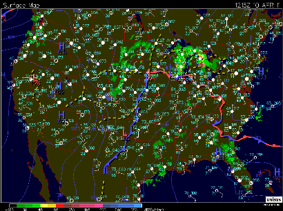
Here was the surface setup at 7:15 AM (1215Z) Sunday morning. The low pressure center with adjacent warm front extended from the Minnesota/Iowa border with a trailing cold front across western Iowa.
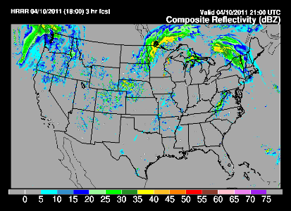
Based on the tornado parameters I was seeing, and knowing that any storms would be racing to the east-northeast very quickly (nearly 60 MPH!) along with the High Resolution Rapid Refresh (HRRR) forecast model showing storm development in southeast Minnesota and western Wisconsin, I chose to chase in an area between Hudson, WI, Menomonie, WI, and Red Wing, MN.
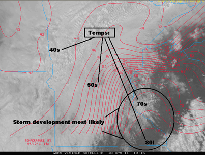
Shortly after 2 PM after stopping at my parents’ place for lunch, I set forth on the road towards Wisconsin. I arrived in Roberts, WI, just north of Interstate 94 shortly after 3 PM to await storm initiation, and to get my live dash camera rolling. As I was driving east, one thing concerned me and that was the cloud cover. I never seemed to get completely away from it and that really prevented surface heating from happening. Cloud tops also had a “milky” appearance to them, which is a sign that instability isn’t great for severe storms. Here is a satellite image and associated cloud cover 2:15 PM, which was put together by Paul Huttner on his Sunday, April 10, blog post. Western Wisconsin broke out into the 70’s for temperatures, but pesky cloud cover really prevented the trigger for strong storm development in my view.
Storms begin to fire along the cold front near Red Wing, MN around 3:08 PM, as depicted on National Weather Service radar from Minneapolis.
Shortly after, a tornado watch with particularly dangerous situation (PDS) emphasis was issued at 3:20 PM by the SPC in anticipation for a widespread tornado outbreak.
Here is radar for the duration of my time chasing out in Wisconsin. Going in with the mindset that it was going to be a bad day based on the cloud cover and the storms moving like rockets, I decided to make this a short chase. There was no severe weather reports associated with any storms until one inch hail was reported in Spring Valley, WI around 3:30 PM and some smaller reports of hail around Menomonie between 4:30 and 4:45 PM. I generally worked the southwest side of the storm cell I was chasing to watch for tornado development instead of punching the core and being hailed on. If I want to chase ice cubes, I would go after the refrigerator in the kitchen. I did find it difficult to keep up with the speed the storms were moving at and also ran into data dead zones, which prevented me from picking up updated radar images. Keep getting behind the storms and when I did catch up, all I experienced was rain. I ended my chase shortly before 5 PM in Menomonie, where temperatures reached 80 degrees before the rain moved in, knowing not much was going to take place. The storms would eventually become tornadic east of Eau Claire in Augusta, where two EF-1 tornadoes touched down on the west and north side of town.
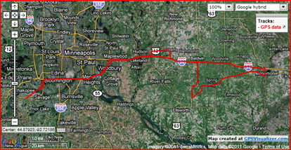
It was a disappointing chase, but I’m also glad the storms were not worse. I encountered college students at UW-Stout, horseback riders, and walkers out enjoying the warm day. Given how rapidly these storms could have intensified and fast movement, people would had little opportunity to find shelter. This could have been a much disastrous situation. Here is a GPS plot of the area I chased this day. I managed to determine the area where the storms would be, but were not of any significance. I had mixed thoughts on this chase. It was good to finally see some storms, however with gas prices climbing, I may need to be more selective with which storms I chase, and how far I travel this year. Storm chasing is definitely not a cheap hobby!
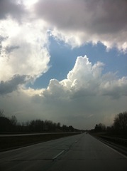
All the media I got from this storm is one photo of clouds heading back home west on I-94 from Menomonie.
RS





No comments:
Post a Comment