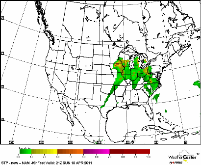
Our first bout of severe weather this year is possible this weekend across many areas of the Upper Midwest as a low pressure system moves in overhead from Nebraska. A warm front draped across Iowa will move northward, drawing up very warm temperatures with readings near 70 degrees, and dew points approaching 60 degrees. Severe weather is possible both days with the slow moving warm front, but I’m anticipating Sunday to have the greatest severe storm potential. All the dynamics are coming together in the upper and lower levels of the atmosphere for a significant severe weather outbreak across several states, including Minnesota.
A tornado threat will exist near the Mississippi River valley Sunday as wind shear will be quite strong - change in direction with height.
Here are the parameters why I’m liking the severe storm chances on Sunday based on the latest NAM models:
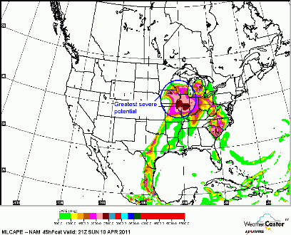
Convective Available Potential Energy (CAPE) values will be well above 1000 joules per kilogram, which is often used as the threshold for thunderstorm development. CAPE indicates the amount of energy available for convection. The higher the number, the greater the potential for severe weather. Far southeast Minnesota, eastern Iowa, most of Illinois, and southern Wisconsin are under the gun for the most active weather. Here are the CAPE values as of 4 PM Sunday:
Another reason why I favor the above area for severe weather are the lapse rates. Lapse rates are the change in temperature with height in the atmosphere. Steep lapse rates, where there is the greatest cooling with height will be found across Iowa into southeastern Minnesota.
With steep lapse rates, also correlates with a weak cap, which will allow for thunderstorm development. A cap, or lid, is warm air aloft that prevents storm development since air particles are restricted from rising to create the large cumulonimbus clouds that form thunderstorms. The cap is the weakest across southeast Minnesota along the Mississippi River into southwest Wisconsin and northern Iowa.
This is shaping up to be quite a stormy weekend. If you have outdoor interests, I would advise to have a plan B and pay attention to the skies. If you see any towering cumulonimbus clouds, it’s a sure sign bad weather is on it’s way. Be safe this weekend and stay tuned for additional updates!
RS


No comments:
Post a Comment