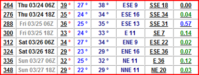
The rest of March is looking to be mild according to the GFS forecast models, with below freezing high temperatures largely behind us. We may even see a shot at 50-degree temperatures by mid-week, which will feel very nice for all us after this winter we have been through. As the temperatures warm up, I’m concerned with the severity of the flooding situation as we may see a couple “waves” of precipitation during the latter half of the month. Each wave may bring around three quarters to an inch of rain, with perhaps some snow mixed in. The first weather system may arrive Sunday, March 20th, and last through Tuesday, March 22th. The second system is advertised as arriving Thursday, March 24th, and lasting through Sunday, March 27th. There may be some change over to snow as the second system moves out of the area as temps drop below freezing.
GFS showing .86 inches of precipitation (in green) between March 20 and March 22:
GFS showing .99 inches of precipitation between March 20 and March 22:
For people in flood prone areas, this is a situation that needs to be monitored closely. Forecasts can and do change this far out, but with record or near-record flood levels being projected across much of the region, this is nothing to take lightly.
RS


No comments:
Post a Comment