I haven’t blogged much lately - trying to avoid thinking winter as much as I can, but with all the attention that this upcoming snowstorm is receiving, along with the flooding potential this spring, I felt it was necessary to post an entry.
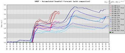
First March 2011 snowstorm: About five days ago, a strong storm system was being advertised on the GFS forecast models for the March 8th-9th timeframe. I know what you’re thinking, “That’s so far out, how can we believe it?” Well, one of the things I picked up on was the very high preliminary snow totals, indicating the strength of the system. At the start, the GFS was indicating over a foot of snow. You don’t see that very often at the onset. Yes, the totals fluctuate and tend to work DOWNWARD rather than trend upward. The question then becomes of the storm track. If the low pressure center tracks in a northern direction, it brings warm air with it and increases the rain/snow mix chances. If it says south, but not too far south and miss completely, we get the cold air that wraps back around the low to produce snow. For the last 5 days, it appeared MSP would take a direct hit from this weather system, but the latest trend is that the storm track will pass just north of St. Louis to around the Chicago area – just brushing southern Minnesota.
Here is the surface map around midnight Wednesday:
Snow totals have been reduced dramatically and now indications are that 2 – 4 inches of snow may fall:
Spring flooding: The new spring flooding outlooks have been released by that National Weather Service, and the forecast for major flooding has increased from the last forecast issued at many locations along the Minnesota and Mississippi Rivers. Generally, many locations have a 90% chance or better at reaching major flood stage, including the Red River Valley of the Fargo-Moorhead area. The year 1965 is being thrown out there as a comparison to the severity of the 2011 flooding will bring. Closer to home, here are my comments that I posted on a spring weather discussion at the Shakopee Valley News website regarding the flooding situation for Shakopee (along with my old snow forecast for early next week!):
My current thinking is that there is a 50/50 chance of flooding reaching 1965 levels. I believe the NWS has the number at 40% as of 3/3/11. We may see an additional six inches of snow or more Tuesday into Wednesday. I also think we will see a sharp transition from winter to spring conditions towards the later half of March resulting in a rapid snow melt. The ground is also very saturated from last fall's precipitation with snow cover preventing deep frost penetration into the soil. Once the ground thaws, this moisture will runoff into rivers and streams.
I completely expect flooding to be of historic/epic proportions. If you have no flood insurance, you need it ASAP. This will be nothing to sneeze at.
La Nina winters have a tendency to bring more snow during early March than normal, which will not help with flooding. I also believe we will see a quick changeover to spring-like weather towards the end of March into April as the cold air is not willing to let go coming into March. Water-snow content is a large reason why flooding is receiving the attention it is. There is still well over a foot of snow in many parts of southwest Minnesota, and in some cases 20 inches! This equates to roughly 10 to 20 inches of water in the snow in close proximity to the Minnesota River basin:
When melting begins this will run off into the river and flow upstream towards the Twin Cities. Any weather impacts over southern MN will have a role in the flooding situation in and around the Twin Cities metro. This is a situation that needs to be monitored closely. I can’t recommend enough to purchase flood insurance, if you live near one of these rivers. Even larger creeks such as Minnehaha and Nine Mile may see water flow above the banks, which residents need to watch. It’s shaping up to be a historic flood event. Stay tuned!
One plug: Follow my Facebook blog page for weather updates as they are warranted, and receive notifications on new posts.
RS


No comments:
Post a Comment