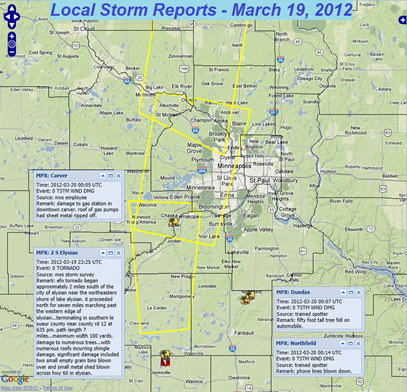
Monday saw the first severe thunderstorms of the year across Minnesota to end the winter season. The National Weather Service in the Twin Cities determined that an EF-0 touched down across Waseca and Le Sueur Counties, impacting the town of Elysian the hardest.
This was the second earliest tornado recorded in the state’s history by one day. The tornado was on the low-end (I avoid the term “weak tornadoes”. ALL tornadoes are capable of causing damage and harming people) and embedded within straight-line winds, making it difficult for meteorologists to detect, thus may explain why no warning was issued when it occurred.
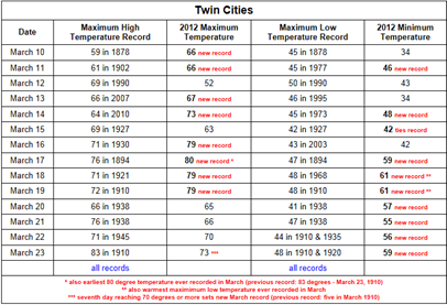
The record-breaking heat wave ended by Tuesday as a cold front moved through the area. 8 out of the 10 days between March 10 and 19th saw new records at MSP. Included in this stretch was the earliest 80 degree reading ever recorded in the Twin Cities, and a record seven days of 70 degree or higher temperatures for March.
Through March 23rd, we are already on our way to the warmest March ever with the average temperature over three degrees warmer than the highest mark set in 1910.
From Bill Stein at The Minnesota Forecaster:
New dew point records were also established in March:
According to the Minnesota State Climatology Office, as noted by Dr. Mark Seeley before the recent warmth, "The highest March dewpoint in the Twin Cities climate record is 60 degrees F on March 24, 1945."
- On March 17th, 19th, and 22nd, a dew point of 60 degrees was reported on hourly observations at Minneapolis St. Paul International Airport, tying the March dew point record.
- March 17th is now the earliest date in the calendar year that a 60 degree dew point has been recorded in the Twin Cities.
Despite a cool down with a couple fronts moving in early next week, temperatures will remain above normal (45 to 49 degrees) for the week with highs at least into the 50s.
Thunderstorm threat will increase for the start of the week with the best chance of storms for Minnesota coming on Tuesday. The parameters for severe weather do not look all that impressive for the state Tuesday. The greatest threat for any severe weather will be Monday to our south and southwest across South Dakota and Nebraska. With the best wind shear over northeast Nebraska, tornadoes will be possible with any supercells expected to develop that day.
We should dry out after Tuesday night and should remain that way until next Saturday when another disturbance moves through the area.
RS


No comments:
Post a Comment