Tuesday, August 30, 2011

Summer is not over yet

As August comes to a conclusion, summer weather is going to stick around a little longer across much of Minnesota, at least through this week.  We’ll see the warmest temperatures this week on Thursday.  Here is the temperature map as of 7 PM Thursday showing the warm air streaming northward:

NAM_221_2011083000_F72_TMPF_2_M_ABOVE_GROUND

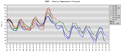
The latest short-term NAM forecast model guidance indicates high temperatures on Thursday will be well into the 90-degree range and close to the century mark.  For this late in the year, it’s quite an amazing feat to have temperatures this warm!

msptemps

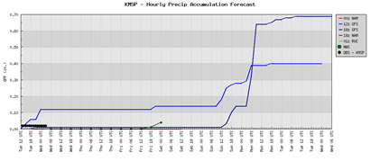
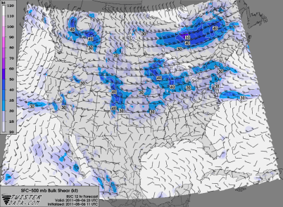
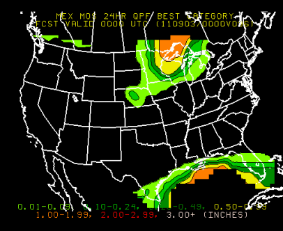
Along with the heat, humidity will return to the area later in the week.  This will provide a better chance of thunderstorms as a cold front cuts through the state.  With strong instability and wind shear in place, some severe weather will be possible later in the day on Thursday and into the overnight hours if the atmospheric cap can break.  Rain amounts will be heavier traveling north where up to an inch of rain may fall across the arrowhead region of Minnesota.

MEX_BQPF24_005Temperatures will drop considerably by the weekend with the frontal passage.  We should see highs in the 60s and a touch of fall will be in the air as we begin September.

RS

Tuesday, August 23, 2011

2011 Minnesota State Fair forecast

minnesota-state-fair-tickets-01

The annual get-together, the Minnesota State Fair, kicks off Thursday and runs through Labor Day.  Here is a look at the weather forecast for the first half of this year’s Fair.

Forecast model spaghetti plots - temperature and precipitation:

fairtemps

fairprecip

  • Thursday:  Dry.  High of 84 degrees.
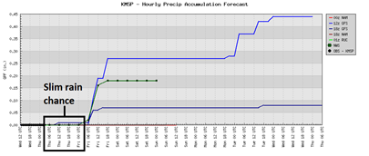
  • Friday: Another nice day.  Slightest chance of rain in the afternoon (10%).  High near 90 degrees if we stay out of the clouds.
  • Saturday:  Cooler, and not as humid.  Dry.  High of 75 degrees.
  • Sunday:  Dry early, then a chance of thunderstorms late in the day during the evening.  High near 75 degrees.
  • Monday:  Chance of rain throughout the day (30%).  High 72.

Enjoy the Fair!

RS

Saturday, August 20, 2011

2012 Minnesota Storm Chasing Convention

Registration has opened for the 2012 Minnesota Storm Chasing Convention, organized by Michael Stanga and Dean Baron.  It will take place on Saturday, January 14, 2012 at the Best Western Kelly Inn in Plymouth, Minnesota.  I decided to skip this year’s convention, but I will be attending in 2012 as the keynote is none other than Reed Timmer.  He is perhaps the most recognized and known storm chaser due in part to his appearance in Discovery Channel's weekly show, Storm Chasers, aired during the fall.

Tickets are $35 per person and are said to be limited to a first come, first serve basis.  All proceeds will go to charities assisting tornado victims.

I attended the inaugural event at St. Cloud State University in 2010, and enjoyed it a lot as Dr. Josh Wurman was the keynote of this conference.  Interesting and informative.  With a couple years under it’s belt now, I suspect that January’s conference will be the best yet!

RS

Wednesday, August 17, 2011

Thursday severe weather threat

A few severe thunderstorms will be possible across northern sections of Minnesota during the latter part of Thursday.  Instability and wind shear will be sufficient to support storms with large hail, strong winds, and perhaps an isolated tornado.  The most widespread, intense storms should stay south and west of the state.

NAM_221_2011081800_F24_EHI_3000_M

A threat for tornadoes exists in the Brainerd lakes area during the evening hours where wind velocity and shear is the greatest.

CONUS_ETA212_ATMOS_STP-NEW_24HR

The Twin Cities area should remain dry with just a very small chance of a passing shower/thunderstorm.  Should be another great day to go along with the majority of this week!

precip

RS

Tuesday, August 16, 2011

A few flooding reports coming in tonight

Some flooding is being reported tonight across the north and northwest of the Twin Cities.  Over two inches of rain has fallen in some parts of the metro in just over a couple hours.

raintotals
  • Spring Lake Park [Anoka Co, MN] law enforcement reports FLASH FLOOD at 07:52 PM CDT -- road impassable due to high water at 81st and hwy 65.

  • Fridley [Anoka Co, MN] law enforcement reports FLASH FLOOD at 07:56 PM CDT -- university ave impassable due to high water between 73rd and osborne. local sewers are backing up due to excessive run off.

  • 8 Nw Princeton [Mille Lacs Co, MN] law enforcement reports FLASH FLOOD at 06:02 PM CDT -- water washed over county road 6 near the intersection of county road 6 and 55th street. nearby culvert washed out.

  • Osseo [Hennepin Co, MN] law enforcement reports FLASH FLOOD at 07:12 PM CDT -- resedential street flooding in osseo. some roads impassable due to high water.

RS

Monday, August 15, 2011

What can we learn from the Indiana State Fair stage collapse?

This post is going to be a bit different.  Instead of providing a forecast or sharing a storm chase,  it will be a reflection and commentary on how we can prevent future weather-related incidents from occurring in the wake of a deadly concert stage collapse at the Indiana State Fair on Saturday night.  With the Minnesota State Fair beginning in a couple weeks and the severe thunderstorm season ongoing across the Midwest, I felt this would be an appropriate time to reflect on the tragedy in Indiana, and understand what proactive measures can be taken to prevent similar incidents from occurring in the future.

The collapse was caused by high winds that moved into the fairgrounds from severe thunderstorms in the vicinity.  As the winds reached the grandstand area where the stage was located, it is believed the winds were as high as 70 MPH.  Here is video of the collapse as onlookers awaited for the arrival of the country singing group, Sugarland.  Five people are known dead, and 45 were injured.

The storms were sparked by a cold front moving through the area during the evening hours on Saturday.  Just before 6 PM local time, a severe thunderstorm watch was issued until early Sunday morning for central Indiana as a line of storms formed in Illinois and moved eastward.

ww0777_radar

As the storms continued east into central Indiana, a Severe Thunderstorm Warning was issued for Marion County, and the Indianapolis area at 8:39 PM local time.  The stage would collapse 10 minutes later, at 8:49 PM.  Here is a radar loop of the storms moving into the Indianapolis area:

IND_N0R_1108140129_912x684_none__0865_an

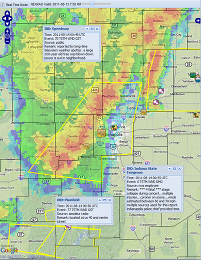
Damaging wind gusts were reported (actual ground truth) with the line of severe thunderstorms near Indianapolis.  Winds of 70 MPH were recorded, just west of Indianapolis, at Speedway in Marion County, and 77 MPH at Plainfield in Hendricks County, west-southwest of Indianapolis.  By rule, any winds over 70 MPH are considered destructive, and the National Weather Service usually goes with this wording in warnings where winds may reach this threshold.  Just to compare straight-line winds to other natural hazards, hurricane-force winds are classified as 74 miles per hour or greater, and EF-0 tornadoes have winds between 65–85 MPH. Here is what radar looked like at 8:50 local time, one minute after initial reports of the concert stage collapsing.  The strongest winds were just out in front of the leading edge of the thunderstorms that extends several miles - an outflow boundary, or “gust front”.  I believe this is the aspect of the storm that caught the public off-guard.
indystorms

According to Indiana State Police, State Fair personnel were in contact with the National Weather Service throughout the day for weather updates.  In reviewing this timeline, communication between the fairgrounds and the local weather service appeared to be adequate as there was an awareness level that severe weather was possible during the day.  This was followed up with additional updates of severe thunderstorm watches/warnings in effect for the area.  There was advanced warning provided by the National Weather Service in Indianapolis. In fact, I thought the local weather service handled this night pretty well overall.  Where the fault lies, in my opinion, is how the weather information was conveyed from State Fair officials to the general public.   An announcement was made to concert attendees by Fair officials at 8:45, six minutes after the warning was issued, of severe weather present and where and when to seek shelter.  Why was there such a delay in relaying this information?  In the world of weather, six minutes is a long time, considering how quickly thunderstorms can move.  In addition, according to The Indianapolis Star, officials did not officially call off the concert, thus thousands of anxious concert go-ers decided against heeding the warning:

But the weather near the Indiana State Fairgrounds was starting to get dicey. Backstage, State Police special operations commander Brad Weaver was watching an ugly storm moving in on radar via his smartphone. He and fair Executive Director Cindy Hoye decided it was time to evacuate the crowd.


But a minute later, when WLHK program director Bob Richards addressed the crowd, the word was that the show would go on, and that the crowd should be prepared to find shelter if things changed. Some of the crowd sensed the danger and left without further word. But the majority remained.

The severity of the thunderstorms was not communicated to the public properly, thus created a confusion as to whether it was necessary to evacuate since Fair officials determined the weather would not be turbulent enough to cancel a concert.  Another issue I have is that State Fair operations likely had no idea of the actual wind reports received with this storm since they are not meteorologists.  If they had tracked storm reports and knew winds in excess of 70 MPH were happening with this line of storms, I think their thought process would have changed a bit.  Weather at the Fair was being monitored by a radar on a cell phone.  Usually this kind of radar information available to cell phone users is basic, and doesn’t provide grand detail of what’s really going on.  It can only tell you so much to an untrained eye, such as where storms are, but to a meteorologist, or someone experienced in the weather field, can interpret particular characteristics on radar.  For example, the “wave” radar return ahead of a thunderstorm, indicating gusty winds with the outflow boundary. Meteorologists can tell you if a storm is rotating, or how fast winds may be moving looking at radar velocities.  This radar loop assembled by AccuWeather details velocity winds heading into the fairgrounds at around 30 meters per second, or 67 MPH.  If that’s enough wind to take down 100-year old trees, it can sure take down a temporary stage that acts like a wind trap.

There has been a growing trend of concerts operating during bad weather.  It feels like the inevitable was going to happen sooner or later as the probabilities would eventually catch up.  Unfortunately, it happened to be the Indiana State Fair where luck ran out.  On August 6th, a stage collapsed because of severe weather before a Flaming Lips performance in Oklahoma.  During the same weekend, Lollapalooza in Chicago narrowly escaped bad weather as the Foo Fighters were set to perform.  In July, a severe storm toppled a stage in Ottawa, Canada when classic rock band Cheap Trick was performing.  Closer to home, severe weather nearly affected people gathered at Huber Park in Shakopee to watch a fireworks display on August 6th as part of the city’s Derby Days (my take on the situation posted at The WeatherDesk here).

This was no “fluke” incident that I have heard some meteorologists and elected public officials use.  We need to stop putting lives in danger and focus on public safety during weather events.  It should not take deaths for change to be made.  During my career working in the corporate world, I have learned over the years from management that it’s always better to be proactive rather than reactive.  A situation like this could have been avoided if practices and policies were changed for dealing with severe weather.  Here are a couple of my recommendations:

  1. A severe thunderstorm warning that affects the event location should be enough to postpone an event until the weather has passed, regardless if there is ground verification of severe weather from spotter networks.
  2. An on-site meteorologist or a private/public meteorologist team should be monitoring conditions 24/7 during the duration of the event, and be in constant communication with event officials since weather can change at a moment’s notice.  We need people trained in the field of weather to call the shots that understand and can interpret weather conditions.  Hazardous weather alerts should be transmitted as they are received so individuals have the maximum amount of time to prepare for bad weather.
  3. For outdoor event attendees, make sure you have a means for receiving weather alerts (i.e. automated text messaging through services such as CellWarn).  Ultimately, it’s up to each individual to look out for their own safety.  If you are attending an outdoor event and receive notification of severe weather in the area from event personnel or through your own channel, you should assume the worst and seek shelter in a sturdy building. It’s better to be safe and live another day.  It’s also important to be up-to-date on weather conditions before heading out the door, and have an expectation for what may happen later in the day. In our information age, there’s really no reason why someone should be unaware of the day’s weather forecast.

With the Minnesota State Fair coming up, I really hope we don’t come close to seeing a repeat of what happened in Indiana.  Injuries and deaths from an incident like this at one event is one occurrence too many.

RS
Thursday, August 11, 2011

Heading into the Dog Days of summer

As you may have noticed, July happened to be a warmer than normal and very humid.  By my count, more than 80% of July days had high temperatures above normal.  The summer has been unusually muggy with 274 hours of dew points of 70 degrees or higher recorded this season as of August 1, 2011.  The record is 512 hours, set in 2002.

What is responsible for the warmer and moist air mass?  We are in a “Ring of Fire” weather pattern.  No, it doesn’t have anything to do with a Johnny Cash song or earthquakes.  Rather, it’s a dome of high pressure, created from longer and stronger daylight, dominating the southern states (and bringing along with it record drought to Texas).  Minnesota resided at the edge of this dome ridge, with the jet stream riding along it that brought rain and some severe weather to the area.  With the jet stream so far north, Gulf moisture was able to surge all the way up into the Upper Midwest, which made our climate feel tropical for an extended length of time.

11JulySevereSetup

As we venture into August, we have witnessed a cold front move through this week that brought humidity and temperatures into a more comfortable level.  90-degree temperatures appear to be a thing of the past as we transition into a cooler weather pattern.  With the cooler weather pattern, severe weather season will begin to wind down quickly over the next few weeks.  However, until about mid-October, severe thunderstorms can never be ruled out completely across the state because of air mass clashes with the changing of the seasons.

MPXSevereWeatherClimo

For those that enjoy the hotter conditions, we should see 80-degree temperatures return in about a week, and perhaps some mid-80s as the Minnesota State Fair begins at the end of this month.  We are in that period where the weather will have something for everyone – a little bit of summer and fall.

RS

Saturday, August 6, 2011

Forecast models put severe storms across central Minnesota today

Thunderstorms will be found Saturday along a frontal boundary that stretches across central sections of Minnesota.

namncsfcwbg

While instability will be modest, there will be enough wind shear (40 to 50 knots) to generate supercells that may eventually evolve into a complex of strong to severe thunderstorms.

RUC_255_2011080611_F12_SHRM_500_MB

A couple of the high resolution forecast models are in agreement of showing thunderstorm activity later this evening across central Minnesota.  Here is how the models are depicting storms at 7 PM today:

refd_1000m_f24

cref_t2sfc_f14

It appears the greatest threat for severe weather will be from the St. Cloud to Brainerd area today.  This activity will push through the state by early Sunday morning, and bringing with it a pleasant day.

Anyone heading up to the cabin later today should keep these forecasts in mind.  Being caught on the lake is the last place you want to be during a thunderstorm.

RS

Wednesday, August 3, 2011

July weather summary and August outlook

The month of July will go down as hot and very muggy.  The Twin Cities experienced a record three consecutive day period of dew points of 80-degrees or higher.  On July 19, a record maximum dew point in the Twin Cities was established of 82 degrees at 3 PM.  The dew point actually reached a higher mark at 84-degrees, however, this was in-between hourly observations, and therefore not recorded.  At MSP, from count, high temperature were at or above average for 26 of the 31 days in the month

KMSP201107plot-2

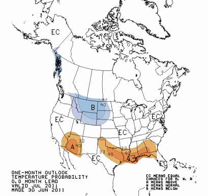
Temperatures were above normal as was predicted by the Climate Prediction Center in their June outlook.  At Minneapolis, the average temperature during the month was 78.8°F, normal temperature of 73.2°F for a departure of 5.6-degrees above normal. At St. Cloud, the numbers were still above average.  The average temperature for the month was 75.1°F, with a normal average temperature of 69.8°F for a departure of 5.3-degrees above normal.

m07_11_tdev

This July had the fifth warmest average temperatures on record, according to the National Weather Service:

Capture 
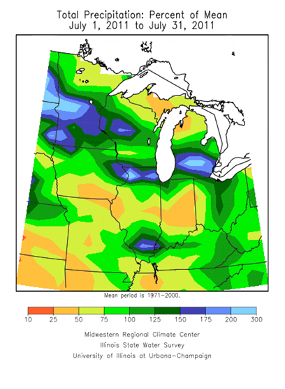
With the heat, saw plenty of rain during the month due to storm systems repeatedly moving throughout the area.  Many places in the state were at or above normal for precipitation.  At Minneapolis, 5.23-inches of rain fell, with an average of 4.04-inches for the month that equates to 1.19-inches of rain above normal.  St. Cloud was even wetter with 5.63-inches of rain, compared to an average of 3.34-inches of rain for 2.29-inches above normal.  These rainfall amounts are consistent with the Climate Prediction Center June outlook.

m07_11_pperc

Looking ahead to August, temperatures will be more seasonal for late summer.  Cooler air stays to the west, while the south continues to scorch in the heat.

off15_temp

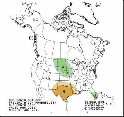
Our rain that stuck around will linger into August.  Chances for above normal precipitation exists for the southwestern two-thirds of Minnesota.

off15_prcp

Enjoy the dog days of summer!  It’s sad to think that summer is almost over after the warmth arrived late this year.

RS

Monday, August 1, 2011

Overnight severe weather threat?

Some of the latest RUC forecast model guidance is indicating very strong severe weather parameters in place across far western Minnesota, near the triple-border point of North Dakota, South Dakota, and Minnesota.  While it may be a bit overdone, there’s quite of bit of dynamics in place for explosive thunderstorms.

RUC_255_2011080123_F04_EHI3_SURFACE

Checking some of the observations around the state, dew points have climbed back up near or into the 80s across this area! That’s tropical!

Storms are expected to push through the state overnight along a cold front with severe weather possibilities maintained throughout the duration.

Make sure your weather radio alert is set to “on” tonight.  It could be quite active!

RS