Tuesday, August 17, 2010

Farmington Tornado

Many of you were probably awaken by wave after wave of strong to severe storms that moved through the Cities during the early morning hours of Friday, August 13th. The National Weather Service in Chanhassen determined that an EF-1 tornado touched down about three miles northwest of downtown Farmington at 3:04 AM CDT. The tornado moved in a northeast direction for 1.5 miles.

Farmington tornado

A fellow weather enthusiast, Tadd Parris, informed me that the tornado was very well defined on the radar velocity scan, which is used to see winds blowing towards and away from the radar site. On a simplistic scale, when the winds come together from both directions, it often forms a “couplet”, which is a very good indicator of strong rotation within a cell. Here we can see a couplet just northwest of downtown Farmington that is circled in yellow from a radar image at 3:07 AM. Based on my research, there was no warning of any kind while the tornado was in progress, so residents would have not received an alert on the weather radios or heard sirens sounding.

While significant damage to residential homes was reported, there were no injuries or deaths thankfully. In populated areas, that can be difficult to avoid.

Saturday, August 14, 2010

Isolated storms and end of the heat

Yesterday’s cold front that moved through Minnesota brought with it the end of the oppressive heat and humidity that the Twin Cities metro area and points southward have experienced the last couple of weeks where we saw record high temperatures tied at MSP. It will also be the end of the streak of rain and damaging winds that the Lakeville/Farmington area experienced.

svr081410

A secondary system, a trough of low pressure, will move across the state today, bringing with it the end of the humid spell for a while.  There will be isolated storms some could be severe, but the setup is very marginal today and widespread activity is not expected later today.  Anything that does pop will occur towards the evening hours.  Hail and winds will be the greatest threats from any of the stronger storms.

MN_statemap

The Storm Prediction Center, which keeps record of storm reports for the U.S. has a preliminary tally of 116 tornado touchdowns in Minnesota this year.  This is amazing!  Who would have thunk that a location in the northern continental part of the country would have more tornadoes than Texas, which has a count of 87.  The number may be dwindled down a bit as research from storm surveys are done by the six National Weather Service offices (Twin Cities, Duluth, La Crosse, WI, Sioux Falls, SD, Aberdeen, SD, and Grand Forks, ND) that serve the state.  Looking at the map, there seems to be a couple local concentrated “tornado alley” pockets.  The first one is around the Alexandria area and a second near Albert Lea.  It’s been an odd year to say the least considering Minnesota had not seen a single tornado for the year as of mid-June!  The severe weather season will be winding up here shortly and then it will be the arrival of the “s” word, which for some people cheer while others dread. Ah, winter.

Enjoy your weekend.

RS

Tuesday, August 10, 2010

Heavy rains

Tuesday’s storms brought heavy rains across the Twin Cities metro area and isolated severe storms.  As of 11:15 PM, downtown Minneapolis has seen 2.5 to 3 inches of rain and pockets of 1.5 to 2.5 inches of rain across far western Hennepin County, northern Scott County around Shakopee, just east of St. Paul, and far southern Dakota County.  The National Weather Service in the Twin Cities has issued a flash flood warning for the central portion of the metro area until 2AM.

image

Fortunately, it appears the rain and potential flooding on the roadways will be gone by the morning rush as the storm sewers will have a chance to catch up with all the rain water. Stay safe.  If you see flooded roadways, don’t attempt to cross, turn around!

RS

Sunday, August 8, 2010

Severe weather threat continues

SPC Outlook 8-8-10

Repeat performance?  Another day of active weather is possible for Minnesota as there is a slight risk of severe storms south of a Alexandria, Milaca, to Stillwater, MN line.  Not expecting tornadoes today, as was the case yesterday southwest of Fergus Falls, and any severe weather that does occur will be isolated.  Damaging winds will be the primary threat.

lsr08072010[1]

Yesterday’s storm reports. Here is a graphical depiction of the storm reports received from Saturday’s storms.  As supercells developed on the Minnesota/Wisconsin border, they had enough spin in the atmosphere to produce tornadoes before moving east-southeast along a frontal boundary draped across Interstate 94 towards St. Cloud and the Twin Cities and dropping fair amounts of rain across the area.

Awesome video. Here’s video of a tornado shot by Andy Gabrielson of SevereStudios near the towns of Doran and Campbell in Wilkin County, located in northwest Minnesota.  This guy always seems to be at the right place at the right time, and has captured some amazing footage this year.  My hats off to him.

RS

Saturday, August 7, 2010

Tornado watch

 ww0584_radar_big[2]

The Storm Prediction Center has issued a tornado watch for much of Minnesota effective until 1 AM local time. The watch includes the following counties: Anoka, Benton, Carver, Chippewa, Chisago, Dakota, Douglas, Hennepin, Isanti, Kanabec, Kandiyohi, McLeod, Meeker, Mille Lacs, Morrison, Pope, Ramsey, Renville, Scott, Sherburne, Sibley, Stearns, Stevens, Swift, Todd, Washington, and Wright. Stay tuned.

RS

Severe threat for August 7th, 2010

SPC Outlook

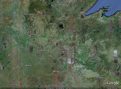
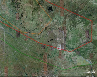
There is a slight risk of severe weather across much of southern Minnesota today, primarily during the afternoon and evening hours.  The trigger for rough thunderstorms is a warm front draped across the central part of the state.  The main weather threat from any storms today will be the potential for damaging winds as highlighted by The Storm Prediction Center for areas inside the red line.  There is also concern about isolated tornadoes with initial storms that development across west central Minnesota from about St. Cloud to Alexandria and points northwest (orange area on the map) before the storm system evolves into a complex during the evening hours in a southeast direction towards the Twin Cities.  For those that have outdoor plans later on today, you will definitely want to keep an eye to the sky.

RS

Sunday, August 1, 2010

7/27/10 Chase: Glencoe, MN

A cold front raced across Minnesota during the evening of Tuesday, July 27th, 2010.  I chased out west along highways US-212 and MN-5 towards Glencoe, MN. The storms were severe in western Minnesota, but lost their intensity as they approached the Twin Cities, only to regain their strength as the line moved into Wisconsin.

MPX.N0R.1007280059.640x480.none..173_an[1]

The leading edge of this line of storms produced nice shelf clouds, indicating strong straight-line winds.  Here is a photo I took of a shelf cloud approaching from the north near the towns of Glencoe and Plato:

IMG_0216

Following the back end of the line of storms on the way home, I experienced some wind and rain.  The real prize of this trip was the lightning strike I captured as I was traveling eastbound on US-212/MN-5 outside of Glencoe:

Nice little storm for an evening chase!

RS