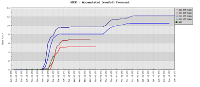
The Twin Cities just made it through one historic snowfall and now may be impacted by another snowstorm Monday night into Tuesday. This storm, based on the forecast models, will not be as large as the one on December 10th and 11th, but it will be enough to plow and slow down the workday commute.
Winter storm watches have been issued:

- Winter Storm Watch valid at Dec 20, 6:00 AM CST for Carver, Chippewa, Dakota, Douglas, Goodhue, Hennepin, Kandiyohi, McLeod, Meeker, Pope, Rice, Scott, Stearns, Stevens, Swift, Todd, Wright [MN] till Dec 21, 6:00 AM CST
- Winter Storm Watch valid at Dec 20, 12:00 PM CST for Anoka, Benton, Chisago, Isanti, Kanabec, Mille Lacs, Morrison, Ramsey, Sherburne, Washington [MN] and Barron, Chippewa, Dunn, Eau Claire, Pepin, Pierce, Polk, Rusk, St. Croix [WI] till Dec 21, 6:00 AM CST
How much snow are we talking? The forecast models are throwing out a range of 5 to 10 inches for the Twin Cities. My hunch right now is that many locales will generally see 6-8 inches of snow. The NAM model tends to be more accurate that the GFS when it comes to winter events. These numbers will change however as we get closer to Monday night and the models get a better grasp of this storm as it has yet to develop. The models update four times a day, so it is possible that we could be looking at significantly different totals tonight, but I'm not betting on it. There has been consistency of placing large amounts of snow over the metro the past couple days, so this storm wouldn’t be something to sneeze at.
How does December 2010 stack up to prior years? Digging through the numbers from the Minnesota Climatology Working Group, the record for December snowfall is 33.2 inches, which occurred in 1969. 2010 is already the snowiest start since 1991. It is quite possible that December 2010 could go down in the books as the snowiest December. Currently, 24.2 inches of snow has fallen so far this month.
Greatest monthly snowfall for December
1. 1969............33.2 "
2. 2000............30.2 "
3. 1968............28.7 "
4. 1950............25.0 "
5. 1902............24.0 "
6. 1996............23.7 "
7. 1927............22.8 "
8. 1983............21.0 "
9. 1982............19.3 "
10. 1909............19.2 "
Stay tuned for further updates.
RS


No comments:
Post a Comment