Wednesday, December 29, 2010

One, two punch

This holiday weekend is shaping up to see two rounds of weather as two low pressure centers track over Minnesota during the day on Thursday and then again on Friday. The two storm tracks are plotted below.

lowtrack_circlesThe first round will be a rain event as temperatures will be well above freezing (temperature projected to be above the freezing mark, the green line, in the chart below) during the day on Thursday before dipping below the 32 degree mark late Thursday night into Friday. This will force the change over from rain to snow.

untitled

Rain totals for Thursday range from two tenths to four tenths. This will create slick roads during the overnight hours into Friday.

untitled

As far as snow goes on Friday, we could see a few inches of snow out of the second system as it moves in, but nothing major. It will be the rain freezing over that will create the greatest problems.

untitled

Welcome to the world of everything!

RS

Sunday, December 26, 2010

Minnesota Vikings at Philadelphia Eagles for Sunday Night Football

A major winter storm is impacting the northeast U.S., which may drop over a foot of snow and blizzard conditions in some places. The Minnesota Vikings are scheduled to play the Philadelphia Eagles on Sunday Night Football. The NFL is considering postponing the game due to the conditions.  Considering what the Minnesota Vikings have been through during the 2010 season, this would only be a fitting exclamation point.  Hey, if they can get a game up and going at TCF Bank Stadium, why can’t they get the field ready at Lincoln Financial Field, home of the Eagles?  A heat pipe system is used at that stadium to keep the grass from going dormant, but are not used to melt snow.  It’s football and snow, what else could you ask for?  Play the game!

Winter storm warnings for the areas shaded in pink, and blizzard warnings for areas in orange, which includes NYC and all of Long Island.

phi

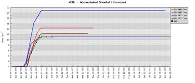
10-14 inches of snow possible for Philadelphia according to the latest NAM and GFS Cobb output through Monday night:

Phillyweather

Just the latest chapter that is the 2010 Vikings season!

RS

Friday, December 24, 2010

New Year’s Eve winter mess?

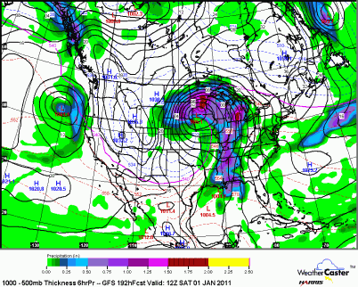
Looking ahead towards New Year’s Eve, there is a chance that this next weather system could cause a real travel headache for New Year’s Eve plans that you may have.  The GFS forecast model is indicating well over an inch of water, which would equate out to over a foot of snow, however, it appears that enough warm air will mix in to create a mix of rain/snow/ice.  You may also notice the tight isobars, which indicate strong winds with the low pressure center that will move along the Minnesota/Iowa border by next Friday night.  This one is looking pretty ugly and I advise you watch for updates if you have to travel.  You may be better off staying home and not risking it if this storm is as advertised, but it’s still a ways out.

CONUS_GFS_1000-500_SLPPRPTHK_192HR

RS

Wednesday, December 22, 2010

Christmas Eve snowstorm?

My blog has been busy with December entries with storm after storm that has moved through the area, dropping significant amounts of snow. New data tonight suggests that the snowfall on Christmas could be a bit on the heavy side. As much as 5 inches of snow could take aim at the southwest portion of the Twin Cities metro with the northeast side of town seeing lighter amounts. This will be one of those storms where the significant snow cutoff lies right over the heart of the Cities. Fortunately, with the latest thaw taking hold over the area, some of the recent snows have begun to melt. This next system could offset any melting that has taken place and could put a wrinkle into Christmas travel. Stay tuned for more updates.

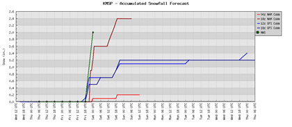
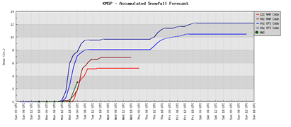
Forecast models based on the MSP airport location showing the lighter amounts of snow. Perhaps an inch or two towards the eastern half of the metro:

untitled

The latest NAM output showing the heavier snow bands over the southwest metro:

00zNAM122310

RS

Tuesday, December 21, 2010

Getting closer to a December record

The official reading at MSP airport from Monday’s snowfall was 4.6”, which brings the monthly total to 28.8”. Track the total here. We are now 4.4” shy of tying the December record that was set in 1969.

The snow headed our way for Thursday and Christmas Eve doesn’t look all that impressive right now. Looks to be about a half inch of snow for most locations. With all the snow we’ve had, we need the break. There is simply no place to put any more snow. It’s already become dangerous trying to navigate residential streets that have snow banks obstructing the view at intersections. Sometimes it feels like Russian Roulette. It’s just one more thing to worry about in life along with work deadlines, holiday shopping, distractions, etc.

Just one other note. I’m quoted in the Shakopee Valley News about the Great Blizzard of 2010 that brought 21.5 inches of snow to Shakopee. That snow total was taken by yours truly. Apparently the city’s snow total was recognized by national media outlets, such as CNN. Here is an online version of the newspaper edition where I’m noted for you to check out:

pnt-12-16-10-p02pnt-12-16-10-p13

I’m honored to be part of a historic event. Never did I think when I took the reading that it would be such a big deal. I’m a little surprised at the total I arrived at, but I have no doubts that the 21.5 inches was a very good approximation to what we got. Measuring snow is truly one of the greatest challenges as a weather observer. There’s blowing and drifting and you really have to use good judgment and react to the situation appropriately. In this case, I took far more measurements before doing an average to ensure I was dealing with a greater level of accuracy. I know there are some naysayers out there, but I did the job to the best of my abilities in a very difficult situation. I would do it all over again if I had too. It’s the curiosity of how much snow is there that interests me.

That’s it for now.

RS

Sunday, December 19, 2010

Sunday night storm update

With the late night forecast model runs, it appears the totals aren’t quite nearly as high as this morning’s runs.

How much? Right now it appears that the Twin Cities metro will see anywhere between 5-8 inches of snow I believe.

00zupdate

Where? The heaviest amounts will be seen on the southwest side of town, much like the last snowfall that impacted portions of the metro area. The areas shaded in dark green below may see up to 8 inches of snow. The snows are expected to begin after the noon hour and linger into the day on Tuesday. Expect a very slow afternoon/evening commute on the roadways.

RS

Just another December snowstorm…

The Twin Cities just made it through one historic snowfall and now may be impacted by another snowstorm Monday night into Tuesday. This storm, based on the forecast models, will not be as large as the one on December 10th and 11th, but it will be enough to plow and slow down the workday commute.

Winter storm watches have been issued:

  • Winter Storm Watch valid at Dec 20, 6:00 AM CST for Carver, Chippewa, Dakota, Douglas, Goodhue, Hennepin, Kandiyohi, McLeod, Meeker, Pope, Rice, Scott, Stearns, Stevens, Swift, Todd, Wright [MN] till Dec 21, 6:00 AM CST
  • Winter Storm Watch valid at Dec 20, 12:00 PM CST for Anoka, Benton, Chisago, Isanti, Kanabec, Mille Lacs, Morrison, Ramsey, Sherburne, Washington [MN] and Barron, Chippewa, Dunn, Eau Claire, Pepin, Pierce, Polk, Rusk, St. Croix [WI] till Dec 21, 6:00 AM CST

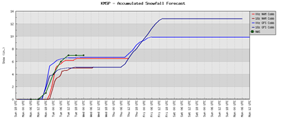
How much snow are we talking? The forecast models are throwing out a range of 5 to 10 inches for the Twin Cities. My hunch right now is that many locales will generally see 6-8 inches of snow. The NAM model tends to be more accurate that the GFS when it comes to winter events. These numbers will change however as we get closer to Monday night and the models get a better grasp of this storm as it has yet to develop. The models update four times a day, so it is possible that we could be looking at significantly different totals tonight, but I'm not betting on it. There has been consistency of placing large amounts of snow over the metro the past couple days, so this storm wouldn’t be something to sneeze at.

untitled

How does December 2010 stack up to prior years? Digging through the numbers from the Minnesota Climatology Working Group, the record for December snowfall is 33.2 inches, which occurred in 1969. 2010 is already the snowiest start since 1991. It is quite possible that December 2010 could go down in the books as the snowiest December. Currently, 24.2 inches of snow has fallen so far this month.

Greatest monthly snowfall for December

1. 1969............33.2 "
2. 2000............30.2 "
3. 1968............28.7 "
4. 1950............25.0 "
5. 1902............24.0 "
6. 1996............23.7 "
7. 1927............22.8 "
8. 1983............21.0 "
9. 1982............19.3 "
10. 1909............19.2 "

Stay tuned for further updates.

RS

Sunday, December 12, 2010

The Great Blizzard of 2010

The Twin Cities experienced the biggest snowstorm since the infamous Halloween Blizzard of 1991. In my opinion, the '91 storm was more impressive because it was over a three day span and dumped nearly 30 inches of snow on the Twin Cities. As an amateur weather forecaster, I underestimated this latest storm just because it appeared on the "radar" only a couple days before it actually happened, which made it difficult to completely buy into the 15-23 inch snow totals from the forecast models.

Here are snowfall totals from the area from this storm:

Here’s how this storm ranks in history with other famous snowfalls from the State Climatology Office:

1. 28.4 inches: 1991 October 31 - November 3 (Halloween Blizzard)

2. 21.1 inches: 1985 November 29 - December 1

3. 20.0 inches: 1982 January 22 – 23

4. 17.4 inches: 1982 January 20 – 21

5. 17.1 inches: 2010 December 10 – 11

6. 16.8 inches: 1940 November 11 - 12 (Armistice Day)

t7. 16.7 inches: 1985 March 3 – 4

t7. 16.7 inches: 1940 March 11 - 14 (tie)

9. 16.5 inches: 1982 December 27 – 28

10. 16.0 inches: 1917 January 20 – 21

It’s going to take a while to completely recover from this storm. Curbs look like snow mountains and many side streets and sidewalks have yet to be plowed. With the arctic chill on it’s way, this snow won’t be melting anytime soon. Living here is definitely “character building”. We put up with a lot here and still manage to find a way to get through it somehow. More snow is possible midweek, but this doesn’t appear to be a major system at this time. Be sure to keep watching this blog for further updates.

RS