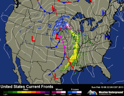
Good morning. Today is a day you will want to plan activities indoors as a mixed bag of precipitation is falling over the Twin Cities metro. Heavy snow and blizzard conditions are expected today across far west central Minnesota. An area of low pressure will track northeastward, across the southeastern portions of the state.
As of 8:30 am, it is freezing rain across the majority of the Twin Cities, with snow falling into Anoka County. Already an inch of snow reported in Andover this morning.
Why are we seeing freezing rain? Although temperatures at the surface are below freezing, there is a temperature inversion between 1000 and 2500 feet, where the air is warming with height. it is above this inversion where temperatures are hovering just greater than freezing (indicated by 0 [°C] line below). Snow is falling from the upper levels of the atmosphere, melting at 0°C, and then re-freezing as water droplets at the surface.
The rain will transition to snow later on Sunday into Monday, but the rain will certainly cut into snow totals across the Twin Cities. For the last few days, I thought the southern Twin Cities would see one to three inches of snow, and the north side would receive three to six inches. I am still sticking to this forecast. We will not see nearly as much snow as some of the models are hinting at. Six to nine inches of snow is possible for west central Minnesota.
Road conditions will deteriorate as the day goes on. An icy layer will likely be found on roads underneath the snow cover, so exercise caution if you have to drive today.
RS


No comments:
Post a Comment