Wednesday, May 1, 2013

A few snow reports from “Mayday” storm

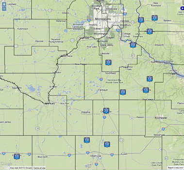
Here are a few snow fall total reports received from the National Weather Service office in Chanhassen.  At last report, MSP Airport has received a trace of snow today.  The record for the month of May stands at three inches.  Owatonna has seen that much today already, with areas just south and east of the Twin Cities receiving two inches or more.

snowreports_05012013

Report Time (UTC) Location County ST Mag. Source
Thu May 2 03:00:00 CDT 2013 Owatonna Steele MN 3 trained spotter
Thu May 2 00:30:00 CDT 2013 Kenyon Goodhue MN 2.4 public
Thu May 2 00:30:00 CDT 2013 Roberts St. Croix WI 2 public
Thu May 2 00:30:00 CDT 2013 River Falls Pierce WI 2 public
Thu May 2 00:40:00 CDT 2013 Castle Rock Dakota MN 2 public
Thu May 2 00:00:00 CDT 2013 Owatonna Steele MN 1.5 trained spotter
Thu May 2 00:30:00 CDT 2013 Fairmont Martin MN 1.5 public
Thu May 2 01:38:00 CDT 2013 Goodhue Goodhue MN 1.5 public
Thu May 2 02:18:00 CDT 2013 Zumbrota Goodhue MN 1.5 public
Thu May 2 00:39:00 CDT 2013 Hartland Freeborn MN 1 public
Thu May 2 00:39:00 CDT 2013 Hollandale Freeborn MN 1 public
Thu May 2 00:40:00 CDT 2013 Hudson St. Croix WI 1 public
Thu May 2 00:47:00 CDT 2013 Hastings Dakota MN 0.8 public

RS

Tuesday, April 30, 2013

Rare May snow fall possible?

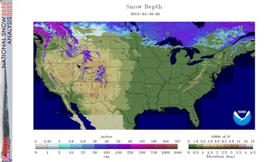
As flip the calendar towards May, you may be thinking that we are out of the woods for snow, right?  After all, the Twin Cities has seen nearly 18 inches of snow in April.  Well, I have some bad news for you.  Some snow is possible as a sharp cold front moves through Tuesday night, and ushers in cold Canadian air out of the northwest, where much of the country is still covered with snow.

nsm_depth_2013043005_National

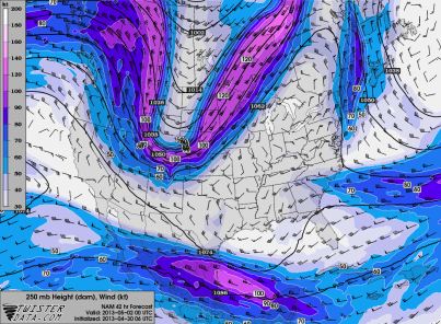
We typically do not receive much snow in May.  The most snow the Twin Cities has ever seen during the month is three inches, which occurred three times.  Could this be a record setting year?  To be honest, it going to be a close call…too close.  It will all depend on where the snow band sets up, and placement of the rain/snow line.  The jet stream is setting up over northwest Minnesota by Wednesday night.

NAM_221_2013043006_F42_WSPD_250_MB

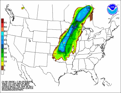
The Weather Prediction Center seems to believe that the likelihood of a couple inches of snow or more sets up across the southeastern Twin Cities metro into southwest Minnesota, including Rochester.

prb_24hsnow_ge02_2013043012f072

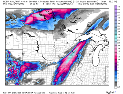
The two major American weather models tend to support this notion from the overnight runs on snow placement.  The NAM model overdoes amounts, but it represents where the heaviest snow will fall.  The GFS is a bit more in line realistically with amounts, and depicts snow amounts in the same general area.

NAM:

BJEhaLpCEAEGaCl

GFS:

Maysnow_GFS

The European model, which as of late tends to be the most accurate because of it’s ability to resolve data, shows the snow band from Duluth to the northwestern Twin Cities suburbs, to Sioux Falls, South Dakota.  At this point, I tend to believe the European is the outlier.

Maysnow_Euro

I think the Twin Cities will see a mixture of rain and snow Wednesday into early Thursday.  The question on accumulation is if we see a changeover to one precipitation type (p-type) during the event.  Still too early to pinpoint precise snow totals, but hopefully tonight will shed a bit more light.  Southeast Minnesota will definitely see snow accumulations.

RS

Monday, April 15, 2013

Minnesota Severe Weather Awareness Week 2013

This week is Severe Weather Awareness Week in Minnesota.  While we have been plagued by snow and cold lately, now is a good time to prepare for severe thunderstorms as we head towards the summer months.  On Thursday, there will be a statewide afternoon and evening tornado drill at 1:45 and 6:55 p.m., respectively.

An understanding of basic terminology is fundamental for severe weather safety.  Here are some terms you will see in the media, from the National Weather Service, and on this blog:

The Storm Prediction Center issues an outlook leading up to when dangerous weather is likely.  These outlooks may be issued as far out as eight days prior to the event.  For a better understanding of these outlooks, this post does an excellent job explaining the Storm Prediction Center products in-depth.

When conditions become favorable for organized severe thunderstorms and/or tornadoes to develop, a watch is issued by the Storm Prediction Center.  It means weather conditions are favorable for dangerous weather to occur. In other words, a "watch" means watch out for what the weather could do, and be ready to act accordingly. You may wish to alter or have a back-up plan for any outdoor activities or travel.  A typical watch duration is six to seven hours, but it may be cancelled, replaced, or re-issued as required.

A warning is issued by the local National Weather Service office when the weather event is imminent or occurring somewhere in the defined warning area, and that people need to take shelter as soon as possible.  These warnings can last as long as 45 minutes to an hour.  New to 2013 is the use of “impact based warnings” by the National Weather Service to emphasize threat and impacts to improve public response.  More information can be found in the video below:

Do you have enough “safety nets” in place for receiving these weather alerts?  Every person should have multiple means other than the outdoor warning sirens for being aware of approaching severe weather.  As I have stated many times before, sirens are only meant to be heard OUTDOORS as a means to get inside a sturdy structure when sirens are sounded.  In addition to the outdoor siren, conventional NOAA Weather Radio should be in every home, much like smoke detectors.  These radios can be set to alert you in standby mode to all or certain hazards within a county or counties, especially during hours of sleep.  It also provides general weather information 24 hours a day, seven days a week.

Many cell phones now feature the ability to receive Wireless Emergency Alerts (WEA), which allow push notifications when the user is within range of an affected hazard area. There are still compatibility issues with this system, mainly with AT&T’s new high-speed LTE network, so I can not recommend this system at this time until it works with all of the phones on the market.  For those who are unable to benefit from WEA, here are a couple apps which work nicely:

I personally prefer iMap Weather Radio as it allows selectable alerts from virtually every weather hazard possible.  Another benefit is that it uses GPS tracking to only alert when the phone is within the watch, warning, or advisory boundaries, unlike NOAA Weather Radio, which is currently limited to entire counties.  This app also features basic radar and Storm Prediction Center outlooks.  For $9.99, it is a bargain in my opinion considering the cost of weather radios run $30 or more.

Some tornado statistics.  From 1950 to 2010, Minnesota averaged 27 tornadoes a year.  Over 75% of the tornadoes during that period occurred in the months of May, June, and July.  The majority of tornadoes happen between 4 and 6 p.m.  When it comes to tornado intensity, Minnesota tornadoes tend to be on the low-end, with more than half being F/EF-0 and F/EF-1 strength.  The last F/EF-5 tornado in the state was in June 1992, affecting the southwestern town of Chandler.  An Enhanced Fujita scale table is found here.

If you have any severe weather or safety questions, please post them below!

RS
Sunday, April 14, 2013

Is Spring around the corner?

Winter has extended it’s stay into April with 6.6 inches of snow having fallen already this month officially in the Twin Cities, with much more across western and northern Minnesota.  Another 2.7 inches needs to fall in the Twin Cities to crack the top 10 snowiest month of April. If there is any silver lining, April snow typically does not stick around long as the sun angle and radiation for this time of the year is able to erode at the snow pack.  Where recent snows have been the heaviest, a foot or more still exists north of the Highway 23 corridor.

snowdepth_0414213

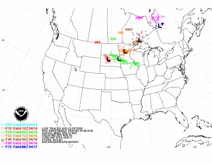
Another episode of never-ending wintery weather is on tap as a low pressure system will move out from the Rockies and into Minnesota today into early Monday. 

lowtrack_ensembles_04142013

North of the low is where heavy snow will occur. Across the Red River Valley is where 6 to 10 inches of snow is possible.  This is an area that does not additional precipitation as major flooding is forecasted for the area.

South of the low is where rain will be found as somewhat warmer air is trying to make it’s way into the southern portions of the state.  The models have been consistent at indicating a chance for freezing rain as temperatures hovering around the freezing point.  The Weather Prediction Center shows high probabilities of this occurring across central and south central Minnesota.  This could make morning roads a bit slick for travel, before we see a change-over to rain for the afternoon.

prb_24hicez_ge_01_2013041412f024

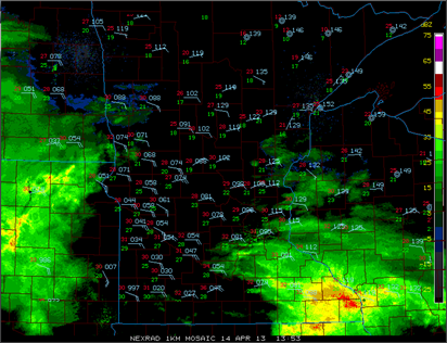
Radar showing the rain marching northward across southern Minnesota.  Rain being reported across south central Minnesota with some mixed precipitation in the Rochester area.  Snow is falling across the southern Twin Cities metro.

radar_04142013_1353

Turning the page?  Recent model trends have indicated a chance of 60 degree weather across southern Minnesota to close out the month.

757862502

We just need a little patience as these temps are still a couple weeks out. We will have to see if this holds up. Models this far out have a tendency to fluctuate a bit. At some point we have to warm up!

RS

Saturday, March 30, 2013

Play Ball!

The Minnesota Twins take the field to open the 2013 MLB season on Monday, April 1st, against reigning American League Champion Detroit Tigers.  This season will mark the earliest outdoor home opener for the team since their arrival to Minnesota in 1961.

After this season, Major League Baseball may have to reconsider scheduling teams in the northern states to open the season at home.  It is going to be downright chilly!  No other way to put it.   While the game is scheduled for April Fool’s, this is no joke.  I consulted with the trusted European model from the overnight run, and it keep temperatures in the 30s around 4 PM Monday.

Euro_TwinsOpener

Some of the mid-morning North American model runs are suggesting that temps will not even make it into the 30s.  However, the models have a tendency to not perform well during seasonal transition periods, so it is possible this data is inaccurate (garbage in = garbage out).  I think low 30s for highs seems likely at this point, about 32 degrees.  Since the Twins have been playing outdoors, the coldest high temperature for opening day was 34 degrees on April 14, 1962.  In fact, that is the only other time the temperature was in the 30s for an outdoor home opener.  If you are attending the game Monday, the moral of the story is keep your winter attire out for at least one more day.  One of these days, you will be able to store it in the closet until next winter.

RS

Wednesday, March 20, 2013

Welcome to Spring…kinda

March Madness

Believe it or not, spring begins at 6:02 AM Central Standard Time!  It certainly will not feel like it, as temperatures start off in the single digits in the morning with wind chill a factor.  Spring has not started this cold since 1965, when the temperature reached a high of 15 degrees in the Twin Cities on March 20 of that year.  Contrast this to the very mild March we had in 2012, where it felt like summer at times with temperatures into the 80s.  With the warm air mass last year came severe weather, as an early tornado occurred on March 19, south of the Twin Cities metro.  Nonetheless, the drastic swing between the two years has made the natives restless, and a particular weather-predicting rodent very unpopular.

45176_10151478860023286_1991886633_n

881962_526067740765603_110529875_o

March started unseasonably chilly as high temperatures are running 20 degrees below normal. Yes, 20, that is not a typo!  We have only reached at or above average for a maximum daily temperature four times this month.

MarTemps_MSP_03202013

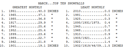
In addition to the cold, it has also been a snowy month as we have reached 13.8 inches of snow for the month – a March surplus of 6.4 inches.  The previous weather system dropped 3.1 inches of snow officially at Minneapolis/St. Paul International Airport.

MarSnows

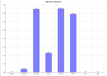
For the season, we have received 49.3 inches of snow. That is around normal for the season - just two tenths above.  Between December, February, and March it has been a pretty even distribution of snow.  February reigns supreme when it comes to most snow with 15.1 inches, but December was right behind, checking in at 15.0 inches.

MSP snow total

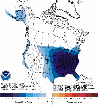
Unfortunately, the rest of March is looking ugly as I alluded to in my video blog.  Below normal temperatures will continue right through the end of the month.  Snow chances return to Minnesota early next week, and the potential is there for at least another couple inches.  I don’t think we will have to worry about any early severe thunderstorm outbreaks this year.

610temp_new

The extended cold snap will also make it difficult to melt away at the snow pack.  North and west of the Twin Cities lies well over a foot of snow.  Roughly two-thirds of the state has this much on the ground right now.  I am concerned about rapid snow melt and the potential for flooding affecting some parts of the state this spring.

snoedepth_032013

When will spring finally arrive?  Only time will tell, but my hunch is that it will be sometime in April.  We can not stay in this pattern forever.

RS

Sunday, March 17, 2013

Weather briefing of upcoming Winter storm

Here is a video blog I created discussing the upcoming winter storm to impact the state.  More of a practice run to get a feel for video blogging.  Let me know if this is medium for presenting information.

RS