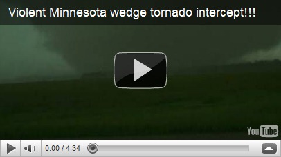
Welcome to 2011. 2010 is now in the books and was a crazy year for weather that Minnesotans experienced. From the snowless March, spring and fall flooding, record number of tornadoes, biggest outbreak of tornadoes in one day, record low pressure readings that brought destructive winds, the greatest winter storm to hit the Twin Cities and surrounding areas since the Halloween Blizzard of 1991, to the snowiest December on record. In reflection on 2010, here are my top 5 weather events for 2010. The top events as voted on by weather enthusiasts are here.
#5 Heavy rainfall on September 22-23, 2010
Waves of heavy rain moved across the southern portion of Minnesota over a two day period on September 22 and 23, triggering instant flash flooding. The highest total rainfall total received in the area was 11.06 inches from an observer in Faribault County, with many areas picking up 8+ inches. Paul Huttner said, “Some central Minnesota [towns] got a summer’s worth of rainfall in one day.” This rain ran off into the Minnesota River, which then flowed upstream into the Mississippi River. Many areas experienced near or record high water levels with this unusually fall flooding event.

Here is video I captured of the Minnesota River flooding as it happened in Shakopee on October 2, 2010.
Locally, this was the seventh highest river crest in Shakopee, reaching 716.5 feet, causing the highway 101 river crossing in Shakopee and highway 41 in Chaska to be closed for a couple weeks until the river receded back into it’s banks.
#4 Record Low Pressure on October 26-27, 2010
On Monday, October 26th, an intense area of low pressure moved from the plains through Minnesota. The low developed in response to powerful jet stream winds from the west, and a major contrast in temperatures – warm, moist air to the south and cold air to the south . At 5:13 pm on Tuesday, October 27, 955.2 millibars (28.21 inches of mercury) was observed at Bigfork, Minnesota, located in the north central part of the state. Powerful winds occurred Tuesday as the low tracked in a south to north direction. Sustained winds of 30 to 45 mph with gusts of 50 to 65 mph were common. Tree branches were knocked down resulting in sporadic power outages. This put those without power in a dangerous situation as artic air moved in with no heat available. Fortunately, utility crews were able to restore power within a day.

Graphic courtesy National Weather Service - Chanhassen
#3 The Great Blizzard of 2010 on December 10-11, 2010
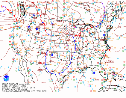
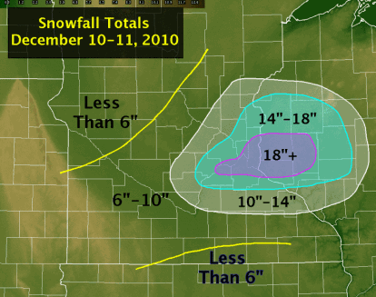
The largest snowfall in almost 20 years for the Twin Cities fell over the days of December 10 and 11. When the snow ended, it would be the largest snowstorm to affect the Twin Cities in December, and the fifth largest snowfall from any one storm on record. Strong winds associated with this storm created blizzard-like conditions across southern Minnesota and the southern parts of the Twin Cities metro, which reduced visibilities to one-quarter mile or less. This resulted in MSP airport being shut down for four hours. 17.1 inches of snow fell at the airport over the two days, and locally, I measured 21.5 inches of snow on the front sidewalk. To the east in Eau Claire, Wisconsin, the city picked up 22 inches of snow in one day, setting a new record.
The weight of all the snow collapsed the roof of the Metrodome in Minneapolis, MN. This was the fifth time the roof has been deflated since it was built in 1981, and fourth time due to heavy snow. Significant damage was done to the roof panels, and it is reported it will take until at least March to make the stadium operable again. Fox Network had cameras in place inside of the Dome and captured the remarkable roof collapse shown below.
#2 104 Tornadoes for 2010
Minnesota saw the greatest number of tornadoes in one year during 2010 with 104 counted by the weather service offices - 71 of these occurring in the month of June. The red dots in the map below are locations where initial tornado reports were made during June. There are two distinct “tornado alleys”, the first over southern third of Minnesota and a second area over northwest Minnesota, north of the the Fargo, ND/Moorhead, MN area.
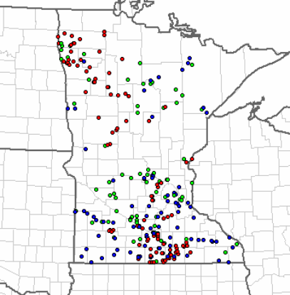
The state shattered the previous annual record of 74, set in 2001. From 1950 to 2010, Minnesota averages 27 tornadoes a year, so the state saw 4 times as many tornadoes in a typical year.
#1 48 Tornadoes on June 17, 2010
The top event on my list is the 48 tornadoes that touched down in Minnesota on June 17, 2010.
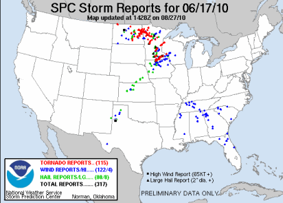
This would go down as the largest single day tornado outbreak in Minnesota history. Previously, 27 tornadoes occurred in the state on June 16, 1992. Most people many know that day for the F-5 tornado that struck Chandler, MN. The Storm Prediction Center noted that it could be a potentially dangerous day by highlighting most of Minnesota for a moderate risk of severe weather.
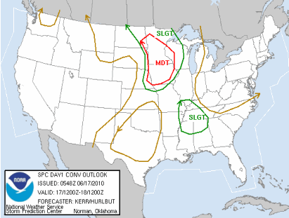
Forecasters warned that there could be significant tornadoes and that people stay tuned for the latest information.
PUBLIC SEVERE WEATHER OUTLOOK
NWS STORM PREDICTION CENTER NORMAN OK
1131 AM CDT THU JUN 17 2010
...SIGNIFICANT SEVERE THUNDERSTORMS EXPECTED OVER THE UPPER MISSISSIPPI VALLEY INTO PARTS OF THE MID MISSOURI VALLEY TODAY AND TONIGHT...
THE NWS STORM PREDICTION CENTER IN NORMAN OK IS FORECASTING THE DEVELOPMENT OF LARGE HAIL...DAMAGING WINDS AND A FEW TORNADOES OVER THE UPPER MISSISSIPPI VALLEY INTO PARTS OF THE MID MISSOURI VALLEY TODAY AND TONIGHT.
THE AREAS MOST LIKELY TO EXPERIENCE THIS ACTIVITY INCLUDE
MUCH OF IOWA
MUCH OF CENTRAL AND SOUTHERN MINNESOTA
FAR EASTERN NEBRASKA
FAR EASTERN SOUTH DAKOTA
FAR WEST-CENTRAL WISCONSIN
ELSEWHERE...SEVERE STORMS ARE ALSO POSSIBLE ACROSS THE NORTHERN PLAINS AND UPPER GREAT LAKES.
A POWERFUL UPPER-LEVEL STORM SYSTEM WILL MOVE EASTWARD TODAY ACROSS THE NORTHERN PLAINS...WHILE AN ASSOCIATED SURFACE LOW PRESSURE CENTER AND TRAILING COLD FRONT SHIFT EWD ACROSS THE DAKOTAS AND NEBRASKA INTO MINNESOTA AND IOWA. A WARM AND HUMID AIR MASS PRESENT AHEAD OF THIS STORM SYSTEM WILL FUEL SEVERE THUNDERSTORM DEVELOPMENT THIS AFTERNOON ALONG THE COLD FRONT INITIALLY OVER THE EASTERN DAKOTAS AND EASTERN NEBRASKA...WITH STORMS SUBSEQUENTLY DEVELOPING EAST INTO MINNESOTA...IOWA AND WISCONSIN THROUGH TONIGHT.
THE WARM/HUMID CONDITIONS IN CONJUNCTION WITH STRONG JET STREAM WINDS WILL FAVOR THE DEVELOPMENT OF INTENSE...SEVERE STORMS INCLUDING SUPERCELLS WITH THE THREAT FOR LARGE HAIL...A FEW TORNADOES --POSSIBLY STRONG-- AND DAMAGING WINDS. WITH TIME...STORMS MAY ORGANIZE INTO A LARGE COMPLEX WITH THE POTENTIAL FOR MORE WIDESPREAD DAMAGING WINDS SPREADING EAST ACROSS PARTS OF MINNESOTA AND IOWA INTO WESTERN WISCONSIN TONIGHT.
STATE AND LOCAL EMERGENCY MANAGERS ARE MONITORING THIS DEVELOPING SITUATION. THOSE IN THE THREATENED AREA ARE URGED TO REVIEW SEVERE WEATHER SAFETY RULES AND TO LISTEN TO RADIO...TELEVISION...AND NOAA WEATHER RADIO FOR POSSIBLE WATCHES...WARNINGS...AND STATEMENTS LATER TODAY.
Three EF-4 tornadoes touched down that day. Two in Otter Tail County, and one on Freeborn County. Three persons died, and there were 45 injuries reported.

One of the most devastated areas from these strong tornadoes was the town of Wadena, MN. Many homes were destroyed as well as the high school and stadium. Storm chaser video by Reed Timmer of the Wadena tornado, shot below.
2010 was a very active and memorable year as far as weather goes in Minnesota. How will 2011 turn out? We will eventually find out, but the record amounts of snow in December has me concerned about major spring time flooding. Forecasters are already concerned along the Red River for the potential of significant spring flooding. This blog will have you covered in 2011 for all things weather! I would also like to take this time to thank all my loyal readers who stopped by in 2010. It’s nice to know there is an audience for this kind of information and that it serves a helpful, useful purpose. If you know someone who might be interested in reading what I have to say, please pass on this blog’s link to them. All are welcome! Here’s to 2011. Cheers!
RS