Showing posts with label flooding. Show all posts

Friday, June 22, 2012

Aftermath of historic Duluth flooding

Rain continued into the day on June 20th, and finally ended when a strong cold front moved through Wednesday afternoon.

600307_10150886732552544_798346428_n

Officially, another 3.10 inches of rainfall was added Wednesday, bringing the total to 7.24 inches over the two days. However, many locations around Duluth saw as much as 10 inches of rain.

Precip_map

preciptableDLH

The Duluth radar shows where the heaviest rain occurred during the historic flood event.  The North Shore to Aitkin County has been declared a disaster area.  Duluth Mayor Don Ness believes that damage from the flooding will be $100 million region-wide.

DP_STA

The mayor claims that “Duluth and the region is open for business … Duluth is safe”, but visitors must be very careful traveling on roadways.  Many of them are compromised with unstable foundations from the flooding.  Sinkholes and washouts are still possible on city roads, even after the rain.  Canal Park is said to be safe to visit, but areas on Duluth’s hillside are still experiencing flooding.  If you are planning to travel to Duluth soon, stay safe!

RS

Wednesday, June 20, 2012

Major flooding in Duluth

A record daily rainfall of 4.14 inches in Duluth on Tuesday triggered flash flooding in the city.  It is believed to be one of the worst flooding events to affect the city 40 years.  Pictures and video from The Weather Channel can be seen here.

A SIGNIFICANT LIFE THREATENING FLOOD EVENT WILL CONTINUE ACROSS THE TWIN PORTS...NORTH SHORE OF LAKE SUPERIOR...AND PARTS OF NORTHWEST WISCONSIN. TRAVEL IS NOT RECOMMENDED IN THE TWIN PORTS EARLY THIS MORNING. THUNDERSTORMS WILL FOCUS ACROSS MOST OF THE NORTHLAND TODAY. DUE TO UNUSUALLY HIGH AMOUNTS OF MOISTURE IN THE ATMOSPHERE...RAINFALL RATES AT TIMES WILL APPROACH 1 TO 2 INCHES PER HOUR. FLOODING WILL CONTINUE TO BE EXACERBATED BY ADDITIONAL RAINFALL. PLEASE REFER TO THE LATEST FLOOD WATCHES AND WARNINGS ISSUED BY THE NATIONAL WEATHER SERVICE IN DULUTH.

Some locations near Duluth saw almost eight inches of rain in one day!

  • Duluth [St. Louis Co, MN] nws employee reports FLOOD at 12:24 AM CDT -- water over the road at highway 53 and maple grove road.
  • Duluth [St. Louis Co, MN] broadcast media reports FLOOD at 02:26 AM CDT -- numerous roads are washed out or flooded within duluth. this includes several sinholes and collapsed roads. reports of high water rescues and evacuations in progress across the city.
  • Duluth [St. Louis Co, MN] broadcast media reports HEAVY RAIN of M6.38 INCH at 02:27 AM CDT -- lester park

Additional reports in the graphic below:

duluthflooding

From the Duluth Police Department:

I-35 IS SHUT DOWN IN BOTH DIRECTIONS AT 40TH AVE W AND IN THE DOWNTOWN TUNNELS AS THE ROAD IS IMPASSABLE DUE TO FLOODING. HIGHWAY 23 IS SHUT DOWN IN FOND DU LAC DUE TO FLOODING. HIGHWAY 61 IS IMPASSABLE ALONG THE NORTH SHORE DUE TO FLOODING. THE FOND DU LAC NEIGHBORHOOD IS BEING EVACUATED AS FLOODING IS EXPECTED DUE TO INCREASED WATER RELEASE FROM THE FOND DU LAC DAM. OFFICIALS REPORTED NUMEROUS SINKHOLES...ROADS WASHED OUT AND MUDSLIDES ACROSS THE CITY OF DULUTH. ONLY EMERGENCY TRAFFIC IS ADVISED.

Definitely an ugly situation up on the North Shore.  Travel to the area is not advised.  I was just up there last weekend for Grandma’s Marathon.  It is amazing what a  difference a couple days makes.  Fortunately, most of the visitors for the race have already left town, minimizing the impact to life.

122

RS

Tuesday, August 16, 2011

A few flooding reports coming in tonight

Some flooding is being reported tonight across the north and northwest of the Twin Cities.  Over two inches of rain has fallen in some parts of the metro in just over a couple hours.

raintotals
  • Spring Lake Park [Anoka Co, MN] law enforcement reports FLASH FLOOD at 07:52 PM CDT -- road impassable due to high water at 81st and hwy 65.

  • Fridley [Anoka Co, MN] law enforcement reports FLASH FLOOD at 07:56 PM CDT -- university ave impassable due to high water between 73rd and osborne. local sewers are backing up due to excessive run off.

  • 8 Nw Princeton [Mille Lacs Co, MN] law enforcement reports FLASH FLOOD at 06:02 PM CDT -- water washed over county road 6 near the intersection of county road 6 and 55th street. nearby culvert washed out.

  • Osseo [Hennepin Co, MN] law enforcement reports FLASH FLOOD at 07:12 PM CDT -- resedential street flooding in osseo. some roads impassable due to high water.

RS

Saturday, June 25, 2011

Minnesota River levels continue to fall

Over the next week, river levels at locations on the Minnesota River in the Twin Cities metro area are expected to drop as the heaviest of the rains stay south across Iowa through Thursday morning:

p120i12

Along the Minnesota River:

  • Shakopee:  FORECAST...THE RIVER IS FORECAST TO HAVE A MAXIMUM VALUE OF 709.0 FEET THIS AFTERNOON.
  • Savage:  AT 7:00 AM SATURDAY THE STAGE WAS 702.8 FEET.  FORECAST...THE RIVER WILL CONTINUE RISING TO NEAR 703.2 FEET BY MONDAY MORNING THEN BEGIN FALLING.
  • Jordan:  AT 7:15 AM SATURDAY THE STAGE WAS 25.9 FEET.  FORECAST...THE RIVER WILL CONTINUE TO FALL TO BELOW FLOOD STAGE BY THURSDAY EARLY AFTERNOON.
  • Montevideo:  AT 7:00 AM SATURDAY THE STAGE WAS 14.6 FEET. FORECAST...THE RIVER WILL CONTINUE RISING TO NEAR 15.2 FEET BY THIS EVENING THEN BEGIN FALLING.
  • New Ulm:  AT 7:00 AM SATURDAY THE STAGE WAS 797.98 FEET.  FORECAST...THE RIVER IS FORECAST TO HAVE A MAXIMUM VALUE OF 799.1 FEET WEDNESDAY EVENING.

Thankfully, we will not see any road closures out of this.  Between the flooding this spring and last fall, we have seen our fair share of traffic inconveniences due to the flooding!

RS

Tuesday, March 22, 2011

Update on Wednesday snows

The latest NAM forecast guidance is in and it appears the trend for a southerly storm track continues from run to run.  This will bring heavy snow to the Twin Cities metro.

Here is a depiction of the low pressure track through the southern half of Iowa:

lowtrack_circles

The low pressure center will bring cold air in behind it across much of Minnesota to set the stage for significant snow:

wrfGL_850_temp_12

Just how much snow?  The NAM is bringing the heaviest snow totals across the northern half of the metro, but the entire metro may see enough snow to plow.  Based on the trend throughout Tuesday for higher snow totals, I’m now projecting the Twin CIties to see anywhere from 6 to 12 inches of snow.  There will be a wide range of snow amounts with this system as the dividing line for heaviest snow bands will setup over or near the Twin Cities.

Capture

Update on warnings for the area.  The National Weather Service expanded the Winter Storm Warnings southward to now include Hennepin and Ramsey Counties through Wednesday.  Flood watches still remain over the southern half of the state where river flooding is expected to occur very soon.  Many areas along rivers will be at or near flood stage right now.  Yesterday and today’s rain accelerated water rises.

warnings

More to come!

RS

Monday, March 21, 2011

Minnesota River pictures and road closures

Here are some pictures along various parts of the Minnesota River in Shakopee and Bloomington that I shot on Saturday.

River running high:

004

Geese enjoying themselves in the snow melt at Huber Park in Shakopee:

024

Ice chunks floating down the river at the Bloomington Ferry Unit of the Minnesota Valley National Wildlife Refuge:

053

066

Video of floating ice chunks:

Road closures

For the latest on Carver County road closures, click on this link.  Scott County can be found here.  I anticipate the County Road 101 and 41 river crossings to be closed as early as Tuesday in preparation of water crossing the roadways based on river forecasts.  It appears that both roads could be under water by Wednesday.

Keep it tuned to this blog for the latest flood coverage!

RS

Saturday, March 19, 2011

Precipitation update for local flooding situation

Well, I hope you have been able to get outside and enjoy the sun and 50-degree temperatures as of late.  It has definitely brought a smile to my face as winter didn’t want to loosen it’s grip this season.  Get out while it lasts, because our weather appears to be transitioning to a wetter pattern over the next week.  Sunday through Wednesday, we will be dealing with rain, then a storm system moves in from Nebraska, drawing enough cold air for more of the s-word, snow.  Yes, Mother Nature isn’t quite done with winter yet, despite astronomical spring beginning Sunday evening.

Forecast map showing where the precip bands lie Wednesday morning.  The heaviest of the snows, we’re not talking much to begin with, stay north of the I-94 corridor:

gfsGL_0_prec_108

So just how much?  The rain that falls before Wednesday will generally be on the light side with amounts less than a half inch.  As the rain transitions to snow on Wednesday, there may be a brief period of freezing rain.  The GFS is hinting at the snow to arrive before noon on Wednesday, in which we could expect a couple inches.  The forecast models become a little more unreliable with the seasonal transitions, so I don’t have a a lot of confidence in the totals or the start and stop times.

Capture

This will have an impact on the flooding situation, and unfortunately the bulk of the precipitation may fall in the Red River basin, which doesn’t need any more rain or snow.  The next few weeks will be a challenge attempting to keep flood waters out as sandbagging efforts start and road closures become more numerous.  I’m attempting to keep this in perspective with what the people of Japan are going through.  This is more of a minor inconvenience for what we have to deal with.

Stay tuned for more updates.

RS

Friday, March 18, 2011

Flood warning summary

Flood warnings were posted Friday for the following locations until further notice...

COTTONWOOD RIVER AT NEW ULM AFFECTING BLUE EARTH...BROWN AND NICOLLET COUNTIES

MINNESOTA RIVER AT MONTEVIDEO AFFECTING CHIPPEWA...LAC QUI PARLE...RENVILLE AND YELLOW MEDICINE COUNTIES

MINNESOTA RIVER AT NEW ULM AFFECTING BLUE EARTH...BROWN AND NICOLLET COUNTIES

MINNESOTA RIVER AT HENDERSON AFFECTING LE SUEUR...SCOTT AND SIBLEY COUNTIES

MINNESOTA RIVER NEAR JORDAN AFFECTING CARVER AND SCOTT COUNTIES

MINNESOTA RIVER AT SHAKOPEE AFFECTING CARVER...HENNEPIN AND SCOTT COUNTIES

REDWOOD RIVER NEAR REDWOOD FALLS AFFECTING REDWOOD COUNTY

MINNESOTA RIVER AT GRANITE FALLS AFFECTING CHIPPEWA...RENVILLE AND YELLOW MEDICINE COUNTIES

MINNESOTA RIVER AT MANKATO AFFECTING BLUE EARTH AND NICOLLET COUNTIES

MINNESOTA RIVER AT SAVAGE AFFECTING DAKOTA...HENNEPIN AND SCOTT COUNTIES

SOUTH FORK CROW RIVER BELOW MAYER AFFECTING CARVER COUNTY

SOUTH FORK CROW RIVER AT DELANO AFFECTING WRIGHT COUNTY

CROW RIVER AT ROCKFORD AFFECTING HENNEPIN AND WRIGHT COUNTIES

MISSISSIPPI RIVER AT ST PAUL AFFECTING DAKOTA...RAMSEY AND WASHINGTON COUNTIES

Stay tuned for further updates.

RS

Wednesday, March 16, 2011

Flood watches now posted

Flood watches are now posted for a few local rivers: Redwood, Cottonwood, and Crow.

FLOOD WATCH
NATIONAL WEATHER SERVICE TWIN CITIES/CHANHASSEN MN
1215 PM CDT WED MAR 16 2011

...THE NATIONAL WEATHER SERVICE IN CHANHASSEN HAS ISSUED A FLOOD
WATCH FOR THE FOLLOWING RIVERS IN MINNESOTA...

REDWOOD RIVER NEAR REDWOOD FALLS AFFECTING REDWOOD COUNTY
COTTONWOOD RIVER AT NEW ULM AFFECTING BLUE EARTH...BROWN AND
NICOLLET COUNTIES
SOUTH FORK CROW RIVER BELOW MAYER AFFECTING CARVER COUNTY
SOUTH FORK CROW RIVER AT DELANO AFFECTING WRIGHT COUNTY


* FLOOD WATCH FOR
THE COTTONWOOD RIVER AT NEW ULM
* FROM LATE FRIDAY NIGHT UNTIL FURTHER NOTICE.
* AT 11:00 AM WEDNESDAY THE STAGE WAS 6.1 FEET.
* MAJOR FLOODING IS POSSIBLE.
* FLOOD STAGE IS 11.0 FEET.
* FORECAST...FLOOD STAGE MAY BE REACHED BY SATURDAY MORNING.

* FLOOD WATCH FOR
THE SOUTH FORK CROW RIVER BELOW MAYER
* FROM SATURDAY EVENING UNTIL FURTHER NOTICE.
* AT 11:30 AM WEDNESDAY THE STAGE WAS 5.2 FEET.
* MINOR FLOODING IS POSSIBLE.
* FLOOD STAGE IS 11.0 FEET.
* FORECAST...FLOOD STAGE MAY BE REACHED BY SATURDAY EVENING.

* FLOOD WATCH FOR
THE SOUTH FORK CROW RIVER AT DELANO
* FROM LATE MONDAY NIGHT UNTIL FURTHER NOTICE.
* AT 11:30 AM WEDNESDAY THE STAGE WAS 9.1 FEET.
* MODERATE FLOODING IS POSSIBLE.
* FLOOD STAGE IS 16.5 FEET.
* FORECAST...FLOOD STAGE MAY BE REACHED BY EARLY TUESDAY MORNING.

* FLOOD WATCH FOR
THE REDWOOD RIVER NEAR REDWOOD FALLS
* FROM SATURDAY MORNING UNTIL FURTHER NOTICE.
* AT 11:30 AM WEDNESDAY THE STAGE WAS 3.9 FEET.
* MINOR FLOODING IS POSSIBLE.
* FLOOD STAGE IS 6.0 FEET.
* FORECAST...FLOOD STAGE MAY BE REACHED BY SATURDAY MORNING.


Stay tuned for further updates as river forecasts are updated, and additional watches are expected.

RS

Sunday, March 13, 2011

Flooding update from National Weather Service

The National Weather Service in Chanhassen issued it’s latest Hydrologic Outlook for the rivers of Minnesota.  It expects flood watches and warnings to be issued by mid-week with snow melt and forecasted precipitation over the next couple weeks.  This is a sign that flood season is upon us, and for over the next month or so, will be a major story across the Upper Midwest.

HYDROLOGIC OUTLOOK NATIONAL WEATHER SERVICE TWIN CITIES/CHANHASSEN MN 549 PM CDT SUN MAR 13 2011

...WARM TEMPERATURES THIS WEEK ARE EXPECTED TO INCREASE MELTING AND POTENTIALLY LEAD TO RIVER FLOODING AS EARLY AS NEXT WEEKEND...

A CHANGE IN THE WEATHER PATTERN WILL BRING WARMER TEMPERATURES TO CENTRAL AND SOUTHERN MINNESOTA AS WELL AS WEST CENTRAL WISCONSIN TUESDAY AND ESPECIALLY INTO WEDNESDAY AND THURSDAY. TEMPERATURES WILL BE IN THE LOWER AND MID 40S ON TUESDAY AND IN THE UPPER 40S AND LOWER 50S ON WEDNESDAY AND THURSDAY. HIGHS ON FRIDAY WILL BE COOLER...BUT STILL IN THE MID 30S IN WEST CENTRAL MINNESOTA TO THE LOWER AND MID 40S IN SOUTH CENTRAL MINNESOTA AND INTO WEST CENTRAL WISCONSIN.

LOWS WEDNESDAY MORNING ARE EXPECTED TO BE IN THE MID TO UPPER 20S WHICH WILL HELP SLOW THE MELTING PROCESS FROM TUESDAY. BUT FOR OVERNIGHT WEDNESDAY NIGHT AND INTO THURSDAY MORNING...TEMPERATURES ARE NOT EXPECTED TO DROP BELOW FREEZING ACROSS SOUTH CENTRAL AND EAST CENTRAL MINNESOTA. PARTS OF WEST CENTRAL WISCONSIN WILL ONLY DROP TO AROUND 40 DEGREES. LOWS FRIDAY MORNING WILL RANGE FROM THE MID 20S IN CENTRAL MINNESOTA TO THE LOWER 30S IN SOUTH CENTRAL MINNESOTA. LOWS IN WEST CENTRAL WISCONSIN WILL DROP INTO THE UPPER 20S. HENCE THE MELTING PROCESS WILL CONTINUE FROM WEDNESDAY THROUGH THURSDAY NIGHT. SO A GOOD 36 HOURS OF STRAIGHT MELTING IS LIKELY.

WE ARE ALSO LOOKING AT A COUPLE OF CHANCES OF LIGHT RAIN IN THE NEXT 7 TO 10 DAYS. THE FIRST CHANCE WILL BE ON TUESDAY. AT THIS TIME THE SYSTEM DOES NOT TAP INTO THE GULF OF MEXICO FOR A MOISTURE SOURCE...SO PRECIPITATION AMOUNTS WILL BE LIGHT AND AROUND A TENTH OF AN INCH OR LESS. ANOTHER SYSTEM WILL MOVE ACROSS THE AREA ON THURSDAY. AS WITH THE TUESDAY SYSTEM PRECIPITATION AMOUNTS ALSO LOOK LIGHT. WE ARE WATCHING ANOTHER STRONGER STORM SYSTEM FOR LATE NEXT WEEKEND AND INTO PART OF NEXT WEEK. THIS ONE MAY BE ABLE TO TAP INTO THE GULF OF MEXICO. THIS SYSTEM IS STILL AT LEAST 7 DAYS OUT IN THE FORECAST SO PATTERNS MAY CHANGE BUT IT IS WORTH WATCHING FOR A RAIN EVENT.

THE WARMING TEMPERATURES FOR THE MIDDLE PART OF THE WEEK ARE EXPECTED TO BEGIN MELTING THE SNOW. AT THIS POINT...WE ARE EXPECTING RISES IN THE MAIN STEM RIVERS BEGINNING...INTO THE LATER PART OF THE WEEK. HOW WARM WE ACTUALLY GET DURING THE DAY...AND HOW WARM WE REMAIN OVERNIGHT AS WELL AS OUR MOISTURE LEVELS AND WINDS...WILL BE THE MAIN DRIVERS FOR THE MELT.

AT THIS POINT WE COULD SEE SIGNIFICANT RISES ESPECIALLY FOR THE COTTONWOOD...REDWOOD...MINNESOTA...CROW AND MISSISSIPPI FOR ST PAUL AND DOWNSTREAM...AND THE ST CROIX RIVER BASINS OVER THE NEXT FIVE TO TEN DAYS. FOR THESE RIVER BASINS...WE COULD POSSIBLY SEE FLOOD STAGE LEVELS AS EARLY AS NEXT WEEKEND.

FOR THE LONG PRAIRE...SAUK...THE MISSISSIPPI RIVER FOR MINNEAPOLIS AND UPSTREAM...EAU CLAIRE AND CHIPPEWA RIVER IN WISCONSIN BASINS...WE ARE LOOKING FOR RISES BUT AT THIS POINT INDICATIONS ARE THAT THEY WILL REMAIN BELOW FLOOD STAGE FOR THE NEXT WEEK.

AS CONFIDENCE INCREASES ON THE MELT AND IMPACTS ON THE RIVERS...RIVER FLOOD WATCHES AND...OR WARNINGS WILL LIKELY BE ISSUED BY WEDNESDAY.

PLEASE REFERENCE THE NWS TWIN CITIES RIVER WEBSITE AT WWW.WATER.WEATHER.GOV/AHPS2/INDEX.PHP?WFO=MPX

Remainder of March: Warm and wet

The rest of March is looking to be mild according to the GFS forecast models, with below freezing high temperatures largely behind us.  We may even see a shot at 50-degree temperatures by mid-week, which will feel very nice for all us after this winter we have been through.  As the temperatures warm up, I’m concerned with the severity of the flooding situation as we may see a couple “waves” of precipitation during the latter half of the month.  Each wave may bring around three quarters to an inch of rain, with perhaps some snow mixed in.  The first weather system may arrive Sunday, March 20th, and last through Tuesday, March 22th.  The second system is advertised as arriving Thursday, March 24th, and lasting through Sunday, March 27th.  There may be some change over to snow as the second system moves out of the area as temps drop below freezing.

GFS showing .86 inches of precipitation (in green) between March 20 and March 22:

imageimage

GFS showing .99 inches of precipitation between March 20 and March 22:

image

For people in flood prone areas, this is a situation that needs to be monitored closely.  Forecasts can and do change this far out, but with record or near-record flood levels being projected across much of the region, this is nothing to take lightly.

RS

Saturday, March 5, 2011

First March snowstorm and local flooding impacts

I haven’t blogged much lately - trying to avoid thinking winter as much as I can, but with all the attention that this upcoming snowstorm is receiving, along with the flooding potential this spring, I felt it was necessary to post an entry.

First March 2011 snowstorm: About five days ago, a strong storm system was being advertised on the GFS forecast models for the March 8th-9th timeframe.  I know what you’re thinking, “That’s so far out, how can we believe it?”  Well, one of the things I picked up on was the very high preliminary snow totals, indicating the strength of the system.  At the start, the GFS was indicating over a foot of snow.  You don’t see that very often at the onset.  Yes, the totals fluctuate and tend to work DOWNWARD rather than trend upward.  The question then becomes of the storm track.  If the low pressure center tracks in a northern direction, it brings warm air with it and increases the rain/snow mix chances.  If it says south, but not too far south and miss completely, we get the cold air that wraps back around the low to produce snow.  For the last 5 days, it appeared MSP would take a direct hit from this weather system, but the latest trend is that the storm track will pass just north of St. Louis to around the Chicago area – just brushing southern Minnesota.

Here is the surface map around midnight Wednesday:

lowtrack030911

Snow totals have been reduced dramatically and now indications are that 2 – 4 inches of snow may fall:

untitled

Spring flooding: The new spring flooding outlooks have been released by that National Weather Service, and the forecast for major flooding has increased from the last forecast issued at many locations along the Minnesota and Mississippi Rivers.  Generally, many locations have a 90% chance or better at reaching major flood stage, including the Red River Valley of the Fargo-Moorhead area.  The year 1965 is being thrown out there as a comparison to the severity of the 2011 flooding will bring.  Closer to home, here are my comments that I posted on a spring weather discussion at the Shakopee Valley News website regarding the flooding situation for Shakopee (along with my old snow forecast for early next week!):

My current thinking is that there is a 50/50 chance of flooding reaching 1965 levels. I believe the NWS has the number at 40% as of 3/3/11. We may see an additional six inches of snow or more Tuesday into Wednesday. I also think we will see a sharp transition from winter to spring conditions towards the later half of March resulting in a rapid snow melt. The ground is also very saturated from last fall's precipitation with snow cover preventing deep frost penetration into the soil. Once the ground thaws, this moisture will runoff into rivers and streams.

I completely expect flooding to be of historic/epic proportions. If you have no flood insurance, you need it ASAP. This will be nothing to sneeze at.

La Nina winters have a tendency to bring more snow during early March than normal, which will not help with flooding.  I also believe we will see a quick changeover to spring-like weather towards the end of March into April as the cold air is not willing to let go coming into March. Water-snow content is a large reason why flooding is receiving the attention it is.  There is still well over a foot of snow in many parts of southwest Minnesota, and in some cases 20 inches!  This equates to roughly 10 to 20 inches of water in the snow in close proximity to the Minnesota River basin:

nsm_swe_2011030505_Upper_Midwest

When melting begins this will run off into the river and flow upstream towards the Twin Cities.  Any weather impacts over southern MN will have a role in the flooding situation in and around the Twin Cities metro.  This is a situation that needs to be monitored closely.  I can’t recommend enough to purchase flood insurance, if you live near one of these rivers.  Even larger creeks such as Minnehaha and Nine Mile may see water flow above the banks, which residents need to watch.  It’s shaping up to be a historic flood event.  Stay tuned!

One plug: Follow my Facebook blog page for weather updates as they are warranted, and receive notifications on new posts.

RS

Thursday, January 27, 2011

Shakopee spring flooding potential

Shakopee Valley Newspaper blog originally posted 1/27/11

The National Weather Service recently released it's outlook on the potential for spring flooding across the Upper Midwest.  As expected with the snow pack, flooding will be a concern.  For the Minnesota River at Shakopee, the numbers look like this:

There is a greater than 98 percent chance, an almost certainty, of waters reaching 711.4 feet, which would result in water reaching the lowest part of Highway 101.

An 89 percent chance exists for water to reach a flood stage of 714 feet, which would put such a crest in the top ten all-time.

Coming in next is an 81 percent chance of a crest reaching an additional foot at 715 feet. This would put it close to the 715.1 crest from March 2010.

Lastly, there is a 78 percent chance of waters reaching a stage of 716 feet, which would put it at number eight all-time.

To put in perspective, flood stage is 708 feet, moderate flooding is 713 feet, and major flood stage is 720 feet. As you can see, there is a strong chance Shakopee will see moderate flooding conditions, which will impact commuters using the 101 crossing, as it will likely be closed if the forecast holds true.  Stay tuned!

RS

Sunday, January 2, 2011

Top 5 Minnesota weather events of 2010

Welcome to 2011. 2010 is now in the books and was a crazy year for weather that Minnesotans experienced. From the snowless March, spring and fall flooding, record number of tornadoes, biggest outbreak of tornadoes in one day, record low pressure readings that brought destructive winds, the greatest winter storm to hit the Twin Cities and surrounding areas since the Halloween Blizzard of 1991, to the snowiest December on record. In reflection on 2010, here are my top 5 weather events for 2010. The top events as voted on by weather enthusiasts are here.

#5 Heavy rainfall on September 22-23, 2010

Waves of heavy rain moved across the southern portion of Minnesota over a two day period on September 22 and 23, triggering instant flash flooding. The highest total rainfall total received in the area was 11.06 inches from an observer in Faribault County, with many areas picking up 8+ inches. Paul Huttner said, “Some central Minnesota [towns] got a summer’s worth of rainfall in one day.” This rain ran off into the Minnesota River, which then flowed upstream into the Mississippi River. Many areas experienced near or record high water levels with this unusually fall flooding event.

ff100922-23

Here is video I captured of the Minnesota River flooding as it happened in Shakopee on October 2, 2010.

Locally, this was the seventh highest river crest in Shakopee, reaching 716.5 feet, causing the highway 101 river crossing in Shakopee and highway 41 in Chaska to be closed for a couple weeks until the river receded back into it’s banks.

#4 Record Low Pressure on October 26-27, 2010

On Monday, October 26th, an intense area of low pressure moved from the plains through Minnesota. The low developed in response to powerful jet stream winds from the west, and a major contrast in temperatures – warm, moist air to the south and cold air to the south . At 5:13 pm on Tuesday, October 27, 955.2 millibars (28.21 inches of mercury) was observed at Bigfork, Minnesota, located in the north central part of the state. Powerful winds occurred Tuesday as the low tracked in a south to north direction. Sustained winds of 30 to 45 mph with gusts of 50 to 65 mph were common. Tree branches were knocked down resulting in sporadic power outages. This put those without power in a dangerous situation as artic air moved in with no heat available. Fortunately, utility crews were able to restore power within a day.

sfclowanimation_gif
Graphic courtesy National Weather Service - Chanhassen

#3 The Great Blizzard of 2010 on December 10-11, 2010
10Dec11_18Zsfcmap

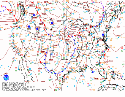
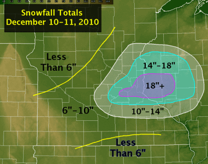
The largest snowfall in almost 20 years for the Twin Cities fell over the days of December 10 and 11. When the snow ended, it would be the largest snowstorm to affect the Twin Cities in December, and the fifth largest snowfall from any one storm on record. Strong winds associated with this storm created blizzard-like conditions across southern Minnesota and the southern parts of the Twin Cities metro, which reduced visibilities to one-quarter mile or less. This resulted in MSP airport being shut down for four hours. 17.1 inches of snow fell at the airport over the two days, and locally, I measured 21.5 inches of snow on the front sidewalk. To the east in Eau Claire, Wisconsin, the city picked up 22 inches of snow in one day, setting a new record.
Dec11_SnowMap4

The weight of all the snow collapsed the roof of the Metrodome in Minneapolis, MN. This was the fifth time the roof has been deflated since it was built in 1981, and fourth time due to heavy snow. Significant damage was done to the roof panels, and it is reported it will take until at least March to make the stadium operable again. Fox Network had cameras in place inside of the Dome and captured the remarkable roof collapse shown below.

#2 104 Tornadoes for 2010

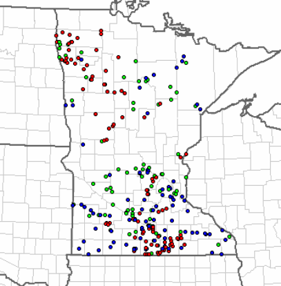
Minnesota saw the greatest number of tornadoes in one year during 2010 with 104 counted by the weather service offices - 71 of these occurring in the month of June. The red dots in the map below are locations where initial tornado reports were made during June. There are two distinct “tornado alleys”, the first over southern third of Minnesota and a second area over northwest Minnesota, north of the the Fargo, ND/Moorhead, MN area.
MN_statemapjune

The state shattered the previous annual record of 74, set in 2001. From 1950 to 2010, Minnesota averages 27 tornadoes a year, so the state saw 4 times as many tornadoes in a typical year.

#1 48 Tornadoes on June 17, 2010

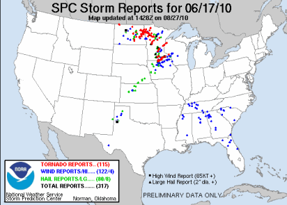
The top event on my list is the 48 tornadoes that touched down in Minnesota on June 17, 2010.
100617_rpts

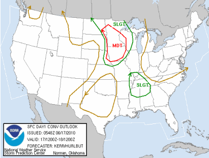
This would go down as the largest single day tornado outbreak in Minnesota history. Previously, 27 tornadoes occurred in the state on June 16, 1992. Most people many know that day for the F-5 tornado that struck Chandler, MN. The Storm Prediction Center noted that it could be a potentially dangerous day by highlighting most of Minnesota for a moderate risk of severe weather.
day1otlk_20100617_1200_prt

Forecasters warned that there could be significant tornadoes and that people stay tuned for the latest information.

PUBLIC SEVERE WEATHER OUTLOOK
NWS STORM PREDICTION CENTER NORMAN OK
1131 AM CDT THU JUN 17 2010

...SIGNIFICANT SEVERE THUNDERSTORMS EXPECTED OVER THE UPPER MISSISSIPPI VALLEY INTO PARTS OF THE MID MISSOURI VALLEY TODAY AND TONIGHT...

THE NWS STORM PREDICTION CENTER IN NORMAN OK IS FORECASTING THE DEVELOPMENT OF LARGE HAIL...DAMAGING WINDS AND A FEW TORNADOES OVER THE UPPER MISSISSIPPI VALLEY INTO PARTS OF THE MID MISSOURI VALLEY TODAY AND TONIGHT.

THE AREAS MOST LIKELY TO EXPERIENCE THIS ACTIVITY INCLUDE

MUCH OF IOWA
MUCH OF CENTRAL AND SOUTHERN MINNESOTA
FAR EASTERN NEBRASKA
FAR EASTERN SOUTH DAKOTA
FAR WEST-CENTRAL WISCONSIN

ELSEWHERE...SEVERE STORMS ARE ALSO POSSIBLE ACROSS THE NORTHERN PLAINS AND UPPER GREAT LAKES.

A POWERFUL UPPER-LEVEL STORM SYSTEM WILL MOVE EASTWARD TODAY ACROSS THE NORTHERN PLAINS...WHILE AN ASSOCIATED SURFACE LOW PRESSURE CENTER AND TRAILING COLD FRONT SHIFT EWD ACROSS THE DAKOTAS AND NEBRASKA INTO MINNESOTA AND IOWA. A WARM AND HUMID AIR MASS PRESENT AHEAD OF THIS STORM SYSTEM WILL FUEL SEVERE THUNDERSTORM DEVELOPMENT THIS AFTERNOON ALONG THE COLD FRONT INITIALLY OVER THE EASTERN DAKOTAS AND EASTERN NEBRASKA...WITH STORMS SUBSEQUENTLY DEVELOPING EAST INTO MINNESOTA...IOWA AND WISCONSIN THROUGH TONIGHT.

THE WARM/HUMID CONDITIONS IN CONJUNCTION WITH STRONG JET STREAM WINDS WILL FAVOR THE DEVELOPMENT OF INTENSE...SEVERE STORMS INCLUDING SUPERCELLS WITH THE THREAT FOR LARGE HAIL...A FEW TORNADOES --POSSIBLY STRONG-- AND DAMAGING WINDS. WITH TIME...STORMS MAY ORGANIZE INTO A LARGE COMPLEX WITH THE POTENTIAL FOR MORE WIDESPREAD DAMAGING WINDS SPREADING EAST ACROSS PARTS OF MINNESOTA AND IOWA INTO WESTERN WISCONSIN TONIGHT.

STATE AND LOCAL EMERGENCY MANAGERS ARE MONITORING THIS DEVELOPING SITUATION. THOSE IN THE THREATENED AREA ARE URGED TO REVIEW SEVERE WEATHER SAFETY RULES AND TO LISTEN TO RADIO...TELEVISION...AND NOAA WEATHER RADIO FOR POSSIBLE WATCHES...WARNINGS...AND STATEMENTS LATER TODAY.

Three EF-4 tornadoes touched down that day. Two in Otter Tail County, and one on Freeborn County. Three persons died, and there were 45 injuries reported.

image

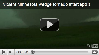
One of the most devastated areas from these strong tornadoes was the town of Wadena, MN. Many homes were destroyed as well as the high school and stadium. Storm chaser video by Reed Timmer of the Wadena tornado, shot below.

2010 was a very active and memorable year as far as weather goes in Minnesota. How will 2011 turn out? We will eventually find out, but the record amounts of snow in December has me concerned about major spring time flooding. Forecasters are already concerned along the Red River for the potential of significant spring flooding. This blog will have you covered in 2011 for all things weather! I would also like to take this time to thank all my loyal readers who stopped by in 2010. It’s nice to know there is an audience for this kind of information and that it serves a helpful, useful purpose. If you know someone who might be interested in reading what I have to say, please pass on this blog’s link to them. All are welcome! Here’s to 2011. Cheers!

RS

Monday, March 22, 2010

From floods to drought?

As we come to the end of March, it's been potentially another record breaking month. Amazingly, the Twin Cities has not seen any snow this month. If this trend continues for MSP, it will be the first time in recorded history that no snow has fallen in March. Certainly this has helped with flooding, but now do farmers, and homeowners that appreciate green lawns, need to be concerned with the lack of water in the ground?


It's dry! The northern metro is already experiencing moderate drought conditions. As the spring green-up occurs and dead undergrowth becomes exposed to dry conditions, it could set the stage for wild brush fires. It is possible that somewhere in Minnesota a Red Flag Warning could be issued during a period in April. This warning is issued when there is a sustained wind average of 15 MPH or greater, a relative humidity less than or equal to 25 percent, and a temperature of greater than 75°F. Last spring, a brush fire started by a resident quickly got out of control in Shakopee that burned 100 acres in a four hour period on tax day, April 15th, 2009. The relative humidity was in the 10-15 percent range during the time of the fire. That's a value that exceeds deserts! Be careful with any burning this year. Better advice: Don't do it!


If you like thunderstorms, you may not like this news. With the lack of precip of any kind this month, this hasn't helped with moisture content at the surface to fuel thunderstorms. Moisture is one key component, along with instability, and differential heating to create a lift for the air. Checking the GFS long-range models, no major storm systems are in sight. The Climate Prediction Center is indicating in it's 30-day outlook that most of Minnesota has equal chances of above, below, or normal temperatures and precipitation. Southern Minnesota could be a little bit on the cooler side around Marshall and Worthington. These factors have given me a gut feeling that April will for the most part be dry. Perhaps May will be different. Each month is like it's own chapter in a climatology book.

This week's outlook. The newest late-night GFS forecast runs are hot off the presses, and it appears that the work week will be dry with a healthy dose of sunshine with above average temps in the high 40s and low 50s. On Saturday, a low-pressure system may trigger some snow flurries, or a slushy mix. It will be a close call as the rain/snow line hovers near.

Enjoy the week!

RS

Saturday, March 20, 2010

Flood video of Minnesota River near Jordan, MN


Moving water from the Minnesota River over Carver County Road 11, 2 miles NNW of Jordan, MN.

Friday, March 19, 2010

2010 Flood pictures

Pictures taken Friday, March 19th of flooding conditions along the Minnesota River in Shakopee and Jordan.

West of County Road 101 and south of the Minnesota River in Shakopee. The river is well out of it's banks. Highway crews were shutting down the 101 river crossing as I was taking these pictures.


Pictures taken 2 miles NNW of Jordan near the Minnesota Valley State Recreation Area (map of general area below):